
Grand Harbour
| Grand Harbour | |
|---|---|
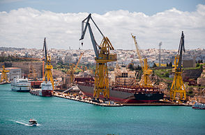
 The Grand Harbour from above | |
 Click on the map for a fullscreen view | |
| Location | |
| Country | Malta |
| Location | Southern Harbour Area |
| Details | |
| Type ofharbour | coastal natural |
| Size of harbour | 2,035,000 square metres (503 acres) |
| Maximum Length | 3.63 kilometres (2.26 mi) |
| Maximum Width | 1.33 kilometres (0.83 mi) |
| Average Depth | 7.7 metres (25 ft) |
This article includes a list of generalreferences,butit lacks sufficient correspondinginline citations.(June 2021) |
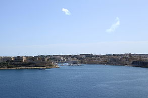
TheGrand Harbour(Maltese:il-Port il-Kbir;Italian:Porto Grande), also known as thePort of Valletta,[1]is anatural harbouron the island ofMalta.It has been substantially modified over the years with extensivedocks(Malta Dockyard),wharves,andfortifications.[2]
Description
[edit]

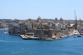
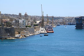
The harbour mouth faces north east and is bounded to the north by Saint Elmo Point and further sheltered by an isolatedbreakwaterand is bounded to the south by Ricasoli Point. Its north west shore is formed by theSciberras peninsula,which is largely covered by the city ofVallettaand itssuburbFloriana.This peninsula also divides Grand Harbour from a second parallel natural harbour,Marsamxett Harbour.The main waterway of Grand Harbour continues inland almost toMarsa.The southeastern shore of the harbour is formed by a number of inlets and headlands, principally Rinella Creek, Kalkara Creek, Dockyard Creek, and French Creek, which are covered byKalkaraand theThree Cities:Cospicua,Vittoriosa,andSenglea.The harbour has been described as Malta's greatest geographic asset.[3]
With its partner harbour of Marsamxett, Grand Harbour lies at the centre of gently rising ground. Development has grown up all around the twin harbours and up the slopes so that the whole bowl is effectively one largeconurbation.Much of Malta's population lives within a three kilometer radius of Floriana. This is now one of the most densely populated areas in Europe. The harbours and the surrounding areas make up Malta'sNorthernandSouthern Harbour Districts.Together, these districts contain 27 of 68local councils.They have a population of 213,722 which make up over 47% of the total population of the Maltese islands.[4]
History
[edit]
The Maltese islands havea long history,mainly due to their strategic location and natural harbours, mainly the Grand Harbour as well as Marsamxett. The Grand Harbour has been used since prehistoric times.
Megalithic remains have been found on the shores of the Grand Harbour. TheKordin Temples,the earliest of which date back to around 3700 BC, overlooked the harbour from Corradino Heights.[5]Another megalithic structure possibly existed underwater off Fort Saint Angelo, but this can no longer be seen.[6]Punic and Roman remains were also found on the shores of the harbour,[5]with the mainCarthaginianport atCospicuapossibly having been the original namesake of the island inGreekandLatin.
By the 12th and 13th centuries, theCastrum Marishad been built in what is nowBirgu.It might have been built instead of ancient buildings, possibly Phoenician or Roman temples, or an Arab fortress.[7]
In 1283, theBattle of Maltawas fought at the entrance of the Grand Harbour.Aragoneseforces defeated a largerAngevinforce and captured 10 galleys.[8]
The Grand Harbour was the base for theOrder of Saint Johnfor 268 years, from 1530 to 1798. They settled in the city ofBirguand improved its fortifications, including rebuilding theCastrum MarisasFort Saint Angelo.In July 1551, Barbary corsairs andOttomanforcesraided Malta.They landed at Marsamxett and marched upon the Grand Harbour, but did not attack as they found the town of Birgu too well fortified to attack. Although this attempt was unsuccessful, the Ottoman force later managed tosack Gozoandconquer Tripoliwithin the same campaign. After the attack,Fort Saint ElmoandFort Saint Michaelwere built to better protect the harbour in any future attacks. The city ofSengleawas also founded soon afterwards.
Later on in the 1550s, atornadostruck the Grand Harbour, killing 600 people and destroying a shipping armada.
The area was the scene of much of the fighting in theGreat Siege of Maltaof 1565 when the Ottomans attempted to eject the Order of St John but were ultimately defeated. After the siege, the capital city ofVallettawas built on the Sciberras peninsula on the north west shore of the harbour. Over the years, more fortifications and settlements were founded within the Grand Harbour, includingFort Ricasoliand the towns ofFlorianaandCospicua.


During theFrench occupation of Malta,the harbour area was blockaded by Maltese rebels on land and theRoyal Navyat sea. The French eventually capitulated in September 1800 and Malta became aBritish protectorate,later acolony.During the British colonial rule, the harbour became a strategic base for the Royal Navy and the base of theMediterranean Fleet.

The whole area was savagely bombed during theSecond Siege of MaltaduringWorld War II,as the docks and military installations around theportbecame targets forAxisbombers.Howevercollateral damagewrecked much of Valletta and The Three Cities, and caused large numbers ofcivilian casualties.AnItalian naval raidon the harbour was repelled on the early of 26 July 1941.

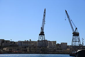
Malta Dockyardis still active but with the departure of theBritish Militarythe harbour lost much of its military significance. A considerable part of Malta'scommercialshippingis now handled by the newfree portatKalafrana,so the harbour is much quieter than it was in the first half of the 20th century.[9]
In September 2007, theMaltese Governmentunveiled 20 proposed regeneration projects that would revamp the area while respecting its historic value.[10]
As of May 2021 the harbour is undergoing renovation works initiated byInfrastructure Maltaand sponsored by theEuropean Unionwith the goals of electrifying the harbour to produce a 90% decrease in harmful emissions from ships.Shorepowerunits are to be installed to eliminate the need forfossil fuel-powered engines to run while ships are docked.[11]
Around the Grand Harbour from Fort Ricasoli to Fort St. Elmo
[edit]

- Fort Ricasoli
- Rinella Bay
- Bighi
- KalkaraCreek
- Fort St. Angelo
- Dockyard CreekorCottonera Marina
- St. Angelo Strand, Birgu
- Xatt il-Forn, Birgu
- Xatt ir-Risq, Birgu
- Xatt San Lawrenz, Birgu
- Dock No. 1,Bormla
- XattJuan B. Azzopardi,Senglea
- Fort Saint Michael
- French Creek
- Dock No. 2
- Ghajn Dwieli Road
- Corradino
- Dock No. 6
- Ras Ħanżir Point
- New Port
- Shipwrights Wharf,Paola
- Dock No. 7
- Xatt il-Mollijiet,Albert Town
- Church Wharf,Marsa
- Il-Menqa
- Bridge Wharf, Marsa
- Flagstone Wharf / Moll iċ-Ċangatura, Marsa
- Lighters Wharf / il-Moll tal-Braken, Marsa
- Timber Wharf / il-Moll tal-Ħatab, Marsa
- Xatt l-Għassara tal-Għeneb, Marsa
- Valletta Waterfrontor Pinto Wharf,Floriana
- Lascaris Wharf,[12]Valletta
- Xatt il-Barriera, Valletta
- Taħt iż-Żiemel
- Fort St. Elmo
Gallery
[edit]
-
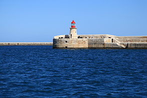 Ricasoli Breakwater
Kalkara -
 Fort Ricasoli
Kalkara -
 Bighi
Bighi
Kalkara -
 Kalkara Creek
Kalkara and Birgu -
 Fort Saint Angelo
Birgu -
 The Spur
Senglea -
 French Creek
Senglea, Cospicua and Paola -
 Dock No. 4
Cospicua -
 Dock No. 6 (China Dock)
Cospicua -
 Shipwrights Wharf
Paola and Marsa -
 Bridge Wharf and Marsa Power Station
Marsa -
 Braken Wharf
Marsa -
 Xatt Lascaris
Valletta -
 Fort Saint Elmo
Valletta -
 St. Elmo Bridge
Valletta -
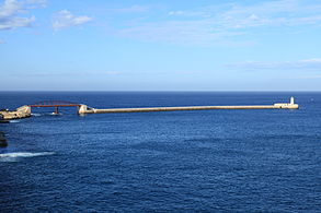 Valletta Breakwater
Valletta


See also
[edit]References
[edit]- ^"Port of Valletta".Transport Malta. Archived fromthe originalon 31 May 2016.Retrieved5 November2014.
- ^Pullicino, Mark (2013).The Obama Tribe Explorer, James Martin's Biography.MPI Publishing. pp. 30–31.ISBN978-99957-0-584-8.OCLC870266285.
- ^Agius, Raymond."The Grand Harbour in Malta".agius.Archived fromthe originalon 11 July 2020.Retrieved5 November2014.
- ^"Estimated Population by Locality 31st March, 2013"(PDF).Malta Government Gazette 19,094. Archived fromthe original(PDF)on 14 July 2014.Retrieved31 October2014.
- ^abVella, Nicholas C. (2004).The Prehistoric Temples at Kordin III.Santa Venera:Heritage Books.ISBN9993239879.
- ^Coppens, Philip."Malta: the small island of the giants".philipcoppens.Retrieved2 May2015.
- ^"Fort St Angelo".Lonely Planet.Retrieved5 November2014.
- ^Said, Frans (30 June 2013)."The Battle of Malta 730 years ago".Times of Malta.Retrieved5 November2014.
- ^Bugeja, Lino (11 August 2013)."The historical importance of Malta's Grand Harbour".Times of Malta.Retrieved31 October2014.
- ^"Government's Vision for Grand Harbour will generate jobs and investment – MEA".The Malta Independent.8 September 2007.Retrieved5 November2014.
- ^"Cavotec Wins Cleantech Contract to Cut Ship Emissions".Manufacturing and Engineering Magazine.18 May 2021. Archived fromthe originalon 19 May 2021.Retrieved19 May2021.
- ^Caruana Dingli, Petra (2018).The Waterside of Valletta: Grand Masters, Travellers and Military Men.Encounters with Valletta: A Baroque City Through the Ages: University of Malta. p. 213–227.