
Gray, Maine
Gray, Maine | |
|---|---|
 A clear view of Loon Island on a calm day on Forest Lake | |
| Motto: "At the Heart of It All" | |
 Location inCumberland Countyand the state ofMaine. | |
| Coordinates:43°52′56″N70°21′19″W/ 43.88222°N 70.35528°W | |
| Country | United States |
| State | Maine |
| County | Cumberland |
| Incorporated | 1778 |
| Villages | Gray Dry Mills East Gray North Gray South Gray West Gray |
| Area | |
| • Total | 45.99 sq mi (119.11 km2) |
| • Land | 43.27 sq mi (112.07 km2) |
| • Water | 2.72 sq mi (7.04 km2) |
| Elevation | 272 ft (83 m) |
| Population (2020) | |
| • Total | 8,269 |
| • Density | 191/sq mi (73.8/km2) |
| Time zone | UTC-5(Eastern (EST)) |
| • Summer (DST) | UTC-4(EDT) |
| ZIP code | 04039 |
| Area code | 207 |
| FIPS code | 23-28870 |
| GNISfeature ID | 0582497 |
| Website | www |
Grayis atowninCumberland County,Maine,United States. The population was 8,269 at the2020 census.[2]It is part of thePortland–South Portland–Biddeford,Mainemetropolitan statistical area.and included in theLewiston-Auburn,Maine metropolitan New England city and town area. Gray is located at the intersection of state Routes 4, 26, 100, 115, 202 and the Maine Turnpike exit 63 midway between the state's two largest cities, Portland and Lewiston. The town includes frontage on Little Sebago Lake, Crystal Lake, and Forest Lake.
Gray is home to regional headquarters for the Maine Department of Inland Fisheries and Wildlife, which maintains afish hatcheryand wildlife park. It is also home to theGray/Portland Weather Forecast Officeof theNOAA's National Weather Service,[3]which issues forecasts and weather warnings forNew Hampshireand western Maine.
History[edit]
The area was granted on March 27, 1736, by theMassachusetts General Courtto a group fromBoston.In 1737, the township was laid out and roads cleared, with the first settlers arriving in the spring of 1738. But during the ongoingFrench and Indian Wars,the settlement was attacked in the spring of 1745 byIndians,who killedcattleand burned the meetinghouse and all dwellings. Inhabitants fled to other towns. In 1751, the village was resettled, but wiped out again in May 1755.[4]
Consequently, Fort Gray was built in 1755. It featured ablockhousemeasuring 50 feet (15 m) long by 25 feet (7.6 m) wide, set within a garrisonpalisade100 feet (30 m) long by 75 feet (23 m) wide. The town had been without a name until about 1756, when it began to be called, Boston, then New Boston and eventually, New Town. On June 19, 1778, New Boston Plantation would be incorporated as Gray after Thomas Gray, a proprietor.[4]
Gray had many farms and some quarries. Other industries included agristmill,12sawmills,atannery,graniteandmarbleworks,carriageandsleighmanufacturer, andshuttlemaker.[5]Along Collyer Brook, Samuel Mayall established in 1791 the first successfulwater-poweredwoolenmillinNorth America.Britishwoolenguildshad prohibited the production of goods in the colonies and tried to prevent British technology from being put to use in competition against them. Mayall smuggled out of England plans for machinery hidden inbalesof cloth meant for trade with theIndians.When the guilds learned of his deception, they tried at least twice to kill him. They sent him a hat in which were hidden pins laced with poison, and then a box with loaded pistols rigged to fire when opened. Suspicious of the packages, Mayall avoided an untimely death. His daughters Mary and Phanela took over the mills when he died in 1831, and built the Lower Mill in 1834. The Mayalls retained ownership until about 1879. The business closed in 1902. The ruins of the mill and associated structures are still visible to this day and are open to the public.[6]
In the 1970s, Gray was chosen as the site of one of tenDecision Information Distribution Systemradio stations, designed to alert the public of an enemy attack. The system was never implemented and the station was not built.
"The Stranger"[edit]

During theCivil War,aConfederatesoldier's body was accidentally sent to Gray. Instead of sending the body away, the "Ladies of Gray" gave the rebel soldier a proper burial and funded a gravestone marked simply, "Stranger". A statue dedicated to the "Unknown Soldier" was later erected in Gray Village Center, and everyMemorial Day,the Unknown Soldier is respected with aConfederate flagmarking the grave. (The Civil War was especially painful for the small town, as they had proportionately sent more men to conflict than any other town in Maine.) Today, there are more than 178Unionsoldiers—and one Confederate—buried in the Gray Village Cemetery.[7]
Geography[edit]
According to theUnited States Census Bureau,the town has a total area of 45.99 square miles (119.11 km2), of which 43.27 square miles (112.07 km2) is land and 2.72 square miles (7.04 km2) is water.[1]Gray, which includes most of Little Sebago Lake and Crystal Lake, is drained by Collyer Brook. Little Sebago Lake has been experiencing problems withmilfoilfor years.
Gray has five towns surrounding it:Windhamto the southwest,Cumberlandto the southeast,North Yarmouthto the northeast,New Gloucesterto the north-northeast andRaymondto the northwest and west. On a north-up map, Gray is the shape of a crooked square.
Gray has long been interconnected with its neighbor to the north, New Gloucester, both sharing similar demographics, culture and economy. They are two of the last rural towns in Southern Maine, with thePortlandarea to the south andLewiston–Auburnto the north. Both towns share the same school district,Maine School Administrative District 15.Being in the vicinity these towns are in, there has been ever-increasing suburban development since the early nineties. Subdivisions and commercial developments have been built at an ever-increasing frequency, leading to the possibility of Gray being swallowed up into the surrounding urban and sub-urban areas in the future.[8]These developments have drawn much protest from residents, many of whom live on the same property as their ancestors many generations ago.
Climate[edit]
| Climate data for Gray, Maine, 1991–2020 normals, extremes 1995–present | |||||||||||||
|---|---|---|---|---|---|---|---|---|---|---|---|---|---|
| Month | Jan | Feb | Mar | Apr | May | Jun | Jul | Aug | Sep | Oct | Nov | Dec | Year |
| Record high °F (°C) | 66 (19) |
63 (17) |
86 (30) |
91 (33) |
95 (35) |
95 (35) |
99 (37) |
96 (36) |
96 (36) |
84 (29) |
76 (24) |
69 (21) |
99 (37) |
| Mean maximum °F (°C) | 52.7 (11.5) |
50.3 (10.2) |
61.6 (16.4) |
75.5 (24.2) |
87.7 (30.9) |
88.3 (31.3) |
90.9 (32.7) |
89.3 (31.8) |
86.6 (30.3) |
75.1 (23.9) |
65.3 (18.5) |
54.5 (12.5) |
92.8 (33.8) |
| Mean daily maximum °F (°C) | 29.8 (−1.2) |
33.1 (0.6) |
41.3 (5.2) |
52.9 (11.6) |
64.3 (17.9) |
73.4 (23.0) |
79.0 (26.1) |
78.2 (25.7) |
70.4 (21.3) |
57.7 (14.3) |
46.1 (7.8) |
35.2 (1.8) |
55.1 (12.8) |
| Daily mean °F (°C) | 22.0 (−5.6) |
24.7 (−4.1) |
32.9 (0.5) |
43.5 (6.4) |
54.2 (12.3) |
63.6 (17.6) |
69.5 (20.8) |
68.6 (20.3) |
60.9 (16.1) |
49.2 (9.6) |
38.8 (3.8) |
28.2 (−2.1) |
46.3 (8.0) |
| Mean daily minimum °F (°C) | 14.2 (−9.9) |
16.4 (−8.7) |
24.6 (−4.1) |
34.0 (1.1) |
44.0 (6.7) |
53.8 (12.1) |
60.1 (15.6) |
58.9 (14.9) |
51.5 (10.8) |
40.8 (4.9) |
31.4 (−0.3) |
21.1 (−6.1) |
37.6 (3.1) |
| Mean minimum °F (°C) | −4.9 (−20.5) |
−1.3 (−18.5) |
6.3 (−14.3) |
24.9 (−3.9) |
35.1 (1.7) |
44.6 (7.0) |
53.9 (12.2) |
50.9 (10.5) |
39.5 (4.2) |
29.5 (−1.4) |
16.4 (−8.7) |
4.2 (−15.4) |
−7.0 (−21.7) |
| Record low °F (°C) | −15 (−26) |
−17 (−27) |
−4 (−20) |
15 (−9) |
31 (−1) |
37 (3) |
47 (8) |
46 (8) |
31 (−1) |
24 (−4) |
3 (−16) |
−10 (−23) |
−17 (−27) |
| Averageprecipitationinches (mm) | 3.55 (90) |
3.34 (85) |
4.01 (102) |
4.40 (112) |
3.56 (90) |
4.73 (120) |
3.73 (95) |
3.84 (98) |
4.32 (110) |
5.42 (138) |
4.65 (118) |
4.59 (117) |
50.14 (1,275) |
| Average snowfall inches (cm) | 20.6 (52) |
20.4 (52) |
16.2 (41) |
4.7 (12) |
0.0 (0.0) |
0.0 (0.0) |
0.0 (0.0) |
0.0 (0.0) |
0.0 (0.0) |
0.6 (1.5) |
3.8 (9.7) |
17.7 (45) |
84.0 (213) |
| Average precipitation days(≥ 0.01 in) | 10.9 | 10.1 | 11.4 | 11.7 | 13.6 | 13.1 | 12.3 | 11.1 | 9.8 | 11.8 | 11.3 | 12.7 | 139.8 |
| Average snowy days(≥ 0.1 in) | 8.7 | 7.9 | 6.3 | 2.2 | 0.0 | 0.0 | 0.0 | 0.0 | 0.0 | 0.2 | 2.3 | 7.4 | 35.0 |
| Source 1: NOAA[9] | |||||||||||||
| Source 2: National Weather Service (mean maxima/minima 2006–2020)[10] | |||||||||||||
Demographics[edit]
| Census | Pop. | Note | %± |
|---|---|---|---|
| 1790 | 577 | — | |
| 1800 | 987 | 71.1% | |
| 1810 | 1,310 | 32.7% | |
| 1820 | 1,479 | 12.9% | |
| 1830 | 1,575 | 6.5% | |
| 1840 | 1,740 | 10.5% | |
| 1850 | 1,788 | 2.8% | |
| 1860 | 1,767 | −1.2% | |
| 1870 | 1,738 | −1.6% | |
| 1880 | 1,798 | 3.5% | |
| 1890 | 1,517 | −15.6% | |
| 1900 | 1,388 | −8.5% | |
| 1910 | 1,270 | −8.5% | |
| 1920 | 1,139 | −10.3% | |
| 1930 | 1,189 | 4.4% | |
| 1940 | 1,378 | 15.9% | |
| 1950 | 1,631 | 18.4% | |
| 1960 | 2,184 | 33.9% | |
| 1970 | 2,939 | 34.6% | |
| 1980 | 4,344 | 47.8% | |
| 1990 | 5,904 | 35.9% | |
| 2000 | 6,820 | 15.5% | |
| 2010 | 7,761 | 13.8% | |
| 2020 | 8,269 | 6.5% | |
| sources:[11] | |||
2010 census[edit]
As of thecensus[12]of 2010, there were 7,761 people, 3,156 households, and 2,187 families residing in the town. Thepopulation densitywas 179.4 inhabitants per square mile (69.3/km2). There were 3,841 housing units at an average density of 88.8 per square mile (34.3/km2). The racial makeup of the town was 97.2%White,0.7%African American,0.2%Native American,0.5%Asian,0.1%Pacific Islander,0.1% fromother races,and 1.2% from two or more races.HispanicorLatinoof any race were 0.9% of the population.
There were 3,156 households, of which 30.5% had children under the age of 18 living with them, 56.0% weremarried couplesliving together, 9.3% had a female householder with no husband present, 4.0% had a male householder with no wife present, and 30.7% were non-families. 20.9% of all households were made up of individuals, and 6.5% had someone living alone who was 65 years of age or older. The average household size was 2.46 and the average family size was 2.85.
The median age in the town was 40.6 years. 21.3% of residents were under the age of 18; 7.5% were between the ages of 18 and 24; 28.2% were from 25 to 44; 32.2% were from 45 to 64; and 10.8% were 65 years of age or older. The gender makeup of the town was 49.7% male and 50.3% female.
2000 census[edit]
As of thecensus[13]of 2000, there were 6,820 people, 2,637 households, and 1,890 families residing in the town. The population density was 157.7 inhabitants per square mile (60.9/km2). There were 3,202 housing units at an average density of 74.0 per square mile (28.6/km2). The racial makeup of the town was 97.89%White,0.43%African American,0.15%Native American,0.38%Asian,0.07%Pacific Islander,0.22% fromother races,and 0.87% from two or more races.HispanicorLatinoof any race were 0.59% of the population.
There were 2,637 households, out of which 33.5% had children under the age of 18 living with them, 60.9% weremarried couplesliving together, 8.0% had a female householder with no husband present, and 28.3% were non-families. 19.7% of all households were made up of individuals, and 7.1% had someone living alone who was 65 years of age or older. The average household size was 2.57 and the average family size was 2.98.
In the town, the population was spread out, with 24.6% under the age of 18, 6.3% from 18 to 24, 34.6% from 25 to 44, 24.6% from 45 to 64, and 9.9% who were 65 years of age or older. The median age was 37 years. For every 100 females, there were 103.2 males. For every 100 females age 18 and over, there were 99.6 males.
The median income for a household in the town was $50,107, and the median income for a family was $55,806. Males had a median income of $36,342 versus $26,433 for females. Theper capita incomefor the town was $22,050. About 1.3% of families and 2.6% of the population were below thepoverty line,including 2.3% of those under age 18 and none of those age 65 or over.
Education[edit]
Photo gallery[edit]
-
 Henry Pennell Municipal Complex
 -
 Centrally located Monument Square in the heart of Gray Village.
 -
 Newly renovated Gray Public Library provides a media hub with books, movies, music, and more.
 -
 Town of Gray Maine Historical Society & Museum
 -
 A clear view of tiny Loon Island on a perfectly calm day on Forest Lake in Gray
 -
 Wilkies Beach Gray Maine
 -
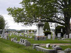 Gray Village Cemetery: Final resting place of approximately 5,500 Gray residents.
 -
 A view of Dry Mills one-room schoolhouse with a meadow filled with spring flowers.
 -
 Stimson Memorial Hall
 -
 Mayall Millc. 1908
 -
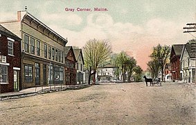 Gray Corner in 1908
 -
 The Elm Housec. 1910
 -
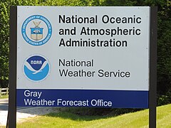 National Weather Service Office in Gray
 -
 National Weather Service Office in Gray


Notable people[edit]
- Wendell Abraham Anderson,politician
- Susan Austin,politician
- Cuke Barrows,professional baseball outfielder
- Todd Chretien,activist
- Walter B. Gibson,author & magician
- Simon Greenleaf,jurist
- Samuel Mayall,U.S. congressman
- Reuben Ruby,entrepreneur and abolitionist
- Warren H. Vinton,state legislator
Sites of interest[edit]
- Town of Gray official website
- Gray Historical Society
- Gray Public Library
- Mayall Mills State Historic Site
References[edit]
- ^ab"US Gazetteer files 2010".United States Census Bureau.RetrievedDecember 16,2012.
- ^"Census - Geography Profile: Gray town, Cumberland County, Maine".United States Census Bureau.RetrievedJanuary 11,2022.
- ^"NWS Gray".National Weather Service.
- ^abCoolidge, Austin J.; John B. Mansfield (1859).A History and Description of New England.Boston, Massachusetts: A.J. Coolidge. pp.143–144.
coolidge mansfield history description new england 1859.
- ^George J. Varney, "History of Gray, Maine" (1886)
- ^History of Mayall Mills
- ^The Stranger
- ^Gray, Maine Zoning MapArchivedJuly 22, 2011, at theWayback Machine
- ^ "U.S. Climate Normals Quick Access – Station: Gray, ME".National Oceanic and Atmospheric Administration.RetrievedMarch 6,2023.
- ^ "NOAA Online Weather Data – NWS Gray/Portland".National Weather Service.RetrievedMarch 6,2023.
- ^"Fogler Library - Maine Census Population Totals - Database Search Results for Minor Civil Divisions".Archived fromthe originalon July 26, 2011.RetrievedMarch 14,2010.,accessed March 2010.
- ^"U.S. Census website".United States Census Bureau.RetrievedDecember 16,2012.
- ^"U.S. Census website".United States Census Bureau.RetrievedJanuary 31,2008.
Municipalities and communities ofCumberland County, Maine,United States | ||
|---|---|---|
| Cities |  | |
| Towns | ||
| CDPs | ||
| Other villages | ||