
Great Mitton
| Great Mitton | |
|---|---|
 The Three Fishes | |
 Great Mitton Shown within Ribble Valley  Great Mitton Location withinLancashire | |
| Population | 266(2011 Census) |
| OS grid reference | SD715385 |
| Civil parish |
|
| District | |
| Shire county | |
| Region | |
| Country | England |
| Sovereign state | United Kingdom |
| Post town | CLITHEROE |
| Postcode district | BB7 |
| Dialling code | 01254/01200 |
| Police | Lancashire |
| Fire | Lancashire |
| Ambulance | North West |
| UK Parliament | |
Great Mittonis a village and a civil parish in theRibble Valley,Lancashire,England.[1]It is separated from the civil parish ofLittle Mittonby theRiver Ribble,both lie about three miles from the town ofClitheroe.The combined population of both civil parishes at the2011 censuswas 266.[2]In total, Great and Little Mitton cover less than 2000 acres of theForest of Bowland,making it the smallest township in the Forest. Historically, the village is part of theWest Riding of Yorkshire,but was transferred to Lancashire for administrative purposes on 1 April 1974, under the provisions of theLocal Government Act 1972.
Great Mitton has an ancient church,All Hallows,an ancient manor house and a pub,The Three Fishes,where in former times manorial courts were held. A second pub,The Aspinall Arms,sits across the Ribble in Little Mitton.
The ancient parish of Mitton took its name from the Old English, being a settlement at themythe,the confluence of theHodderand Ribble Rivers.
History
[edit]TheDomesdaymanor of Mitton encompassed both Great and Little Mitton, straddling lands on both sides of the Ribble. From the late eleventh century, it fell under theLordship of Bowland,the Lords of Bowland beinglords paramountof aRoyal Forestand aLibertyof ten manors spanning eight townships and four parishes and which covered an area of almost 300 square miles (780 km2) on the historic borders of Lancashire andYorkshire.[3]The manors within the Liberty wereSlaidburn(Newton-in-Bowland,West Bradford,Grindleton),Knowlmere,Waddington,Easington,Bashall Eaves,Mitton, Withgill (Crook),Leagram,HammertonandDunnow (Battersby).[4]
Mitton was amesnemanor from the early twelfth century. Its first lord, Radulphus le Rus, may have been a scion of thede Lacyfamily. Descendants of Radulphus assumed the surnamede Mitton.In the late thirteenth century, the family adopted the surnamede Sotheron,laterSherburne,by marriage, thereby laying the foundation for the dynasty of Shireburne ofStonyhurst.The manor passed out of Shireburne ownership in the fourteenth century but was re-acquired in 1665. With the extinction of the Shireburne male line in 1717, the manor passed to the Hawksworth and finally, Aspinall families.[5]
TheMitton Hoardof eleven medieval silver coins (or bits of coins) was found to the west of the village near the River Hodder. The coins are now inClitheroe Castle Museum.[6]
The manor of Withgill (Crook) lay within the boundaries of the township of Mitton but was small (around 40 acres in 1258). It was held by thede Buryfamily until the late fourteenth century. The Singletons held the manor from 1379-1503 after which it passed to the family of Sir William Leyland and finally, the Tyldesleys. The Tyldesleys, leading Jacobites, forfeited the manor for their role in the 1715Preston Rebellion.[5]
The historical Parish of Great Mitton comprised thetownshipsofOld Laund Booth,andAighton, Bailey and ChaigleyinBlackburnshire,and thechapelriesofGrindletonandWaddington,and townships ofBashall Eaves,West BradfordinStaincliffeand Mitton itself which straddled the two.[7]
Sir William Addison(1905–1992), historian and author, was born at Milton.[8][9]
Governance
[edit]The civil parish of Great Mitton was created from the ancient township with the same name in 1866.[10]
Great Mitton was part of theWest Riding of Yorkshireuntil it ceased to exist as an administrative entity in 1974. The parish currently shares aparish councilwith the neighbouring civil parishes ofBashall EavesandLittle Mitton.
Church
[edit]All Hallows Church (previously known as the Church of St Michael) was built in the 13th century, with 15th and 16th century additions. It contains Shireburne ofStonyhurstfamily tombs. Since 1954, it has been designated a Grade Ilisted buildingbyEnglish Heritage.[11]
Gallery
[edit]-
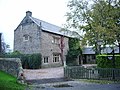 Great Mitton Hall
 -
 Confluence of the Hodder and Ribble
 -
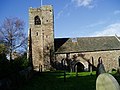 All Hallows Church
 -
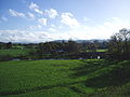 View across the Ribble


See also
[edit]References
[edit]- ^Great Mittonhttp:// genuki.org.uk/big/eng/YKS/WRY/Greatmitton
- ^UK Census(2011)."Local Area Report – Great Mitton Parish (1170215110)".Nomis.Office for National Statistics.Retrieved24 February2018.
- ^"Lord of the Fells, Guardian of History"(PDF).Rural Life.November 2014.
- ^Forest of Bowland official website
- ^abFrederick George Ackerley,A History of the Parish of Mitton in the West Riding of Yorkshire(Aberdeen University Press 1947)
- ^Coin hoard BM-193206,Finds.org.uk, Retrieved 16 September 2015
- ^"GENUKI: Great Mitton".Extracts from Lewis's Topographical Dictionary of England 1835.Retrieved30 April2011.
- ^Kneale, Kenneth (1992);Essex Heritage,Leopards Head Press, pp. 3–14.ISBN0904920232
- ^Morris, Richard; "Sir William Addison (1905-1992) – a retrospective" inLoughton and District Historical Society: Newsletter 165,March/April 2005, pp. 3–5
- ^"History of GREAT MITTON".visionofbritain.org.uk.Retrieved25 April2011.
- ^Historic England."Church of All Hallows (1163432)".National Heritage List for England.Retrieved30 April2011.