
Gualcince
This articleneeds additional citations forverification.(January 2023) |
Gualcince | |
|---|---|
Municipality | |
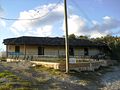
 Panoramic View of Gualcince | |
 Gualcince Location in Honduras | |
| Coordinates:14°07′N88°33′W/ 14.117°N 88.550°W | |
| Country | Honduras |
| Department | Lempira |
| Municipality since | 1840 |
| Area | |
| • Total | 163 km2(63 sq mi) |
| Population (2015) | |
| • Total | 11,564 |
| • Density | 71/km2(180/sq mi) |
Gualcince(Spanish pronunciation:[ɡwalˈsinse]) is amunicipalityin theHondurandepartmentofLempira.
It is one of the several municipalities of theLempira department.It is located 78 km fromGraciascity. It is necessary to pass by San Juan,Intibucaand through the municipalities ofSanta CruzandSan Andrés.It has 2 accesses, which separate from the main road that leads to southern municipalities. The road is constantly being repaired. There are several sections of this roads that are narrow, so careful driving is advised, especially for buses and trucks.
History
[edit]It was first called "Gualán". There is no accurate date for its foundation, but in some old books of real state, it is registered that the Catholic Church was built back in 1,576. In the census of 1,791 it was the capital of the "Cerquin" curato. In the national division of 1889 was one of the municipalities ofCandelariadistrict. It became a municipality in 1840.[citation needed]
Geography
[edit]It has huge mountains covered with pine forests. One of them is "Congolon" mountain. These mountain are favorable for coffee plantations and also for water springs.[citation needed]
Boundaries
[edit]Its boundaries are:
- North:San AndrésandErandiquemunicipalities.
- South:MapulacaandCandelariamunicipalities.
- East:Piraeramunicipality.
- West:La Virtudmunicipality.
- Surface Extents:163 km²
Resources
[edit]The Coffee plantations are the main economical activity, and the geography has a lot to do with it. Corn and beans can not be excluded since they are part of the national diet. The cattle raising is only for local consumption. The vegetables are scarce there for they are brought from other municipalities and even from other departments, such asIntibuca.[citation needed]
Population
[edit]The cross-breed of Spanish settlers and native Indian represents half of the population. The 2nd half consists of native Indians descendants.
- Population:this municipality had approximately 9,537 people. The INE used this figure to elaborate estimates, and the number of people in 2008 could be 10,681.
- Villages:12
- Settlements:103
Demographics
[edit]At the time of the 2013 Honduras census, Gualcince municipality had a population of 11,295. Of these, 73.69% wereIndigenous,20.64%Mestizo,0.89%Black or Afro-Honduran,0.19%Whiteand 4.59% others.[1]
Tourism
[edit]Gualcince displays incredible landscapes of high, steep pine forest mountains, and very old buildings such as the Catholic Church and some houses that are still occupied. It does not have any hostels, butCandelariais 40 minutes away. Grocery stores make it easier to spend some time there. One popular dish there, are the "Pupusas de Flor de Oroco".
- Local Holidays:December 8; "Inmaculapa Concepcion" day.
Gallery
[edit]-
 Old Colonial Church of Gualcince
 -
 Mayor's Office of Gualcince
 -
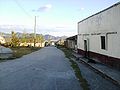 Streets of Gualcince
 -
 A Street in Gualcince
 -
 A Street in Gualcince


References
[edit]Capital:Gracias | ||
| Municipalities |  | |
14°07′N88°33′W/ 14.117°N 88.550°W
ThisHonduraslocation article is astub.You can help Wikipedia byexpanding it. |