Guapituba (CPTM)
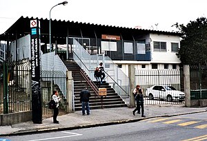
 View of the entrance of Guapituba station in 2014. | ||||||||||||||||||||||||||||||||||||||||||||||||||||||||||||||||||||||
| General information | ||||||||||||||||||||||||||||||||||||||||||||||||||||||||||||||||||||||
| Location | Av. Capitão João, s/n Jardim Guapituba Brazil | |||||||||||||||||||||||||||||||||||||||||||||||||||||||||||||||||||||
| Coordinates | 23°41′32″S46°26′55″W/ 23.692172°S 46.448532°W | |||||||||||||||||||||||||||||||||||||||||||||||||||||||||||||||||||||
| Owned by | ||||||||||||||||||||||||||||||||||||||||||||||||||||||||||||||||||||||
| Operated by | ||||||||||||||||||||||||||||||||||||||||||||||||||||||||||||||||||||||
| Platforms | Side platforms | |||||||||||||||||||||||||||||||||||||||||||||||||||||||||||||||||||||
| Construction | ||||||||||||||||||||||||||||||||||||||||||||||||||||||||||||||||||||||
| Structure type | At-grade | |||||||||||||||||||||||||||||||||||||||||||||||||||||||||||||||||||||
| Other information | ||||||||||||||||||||||||||||||||||||||||||||||||||||||||||||||||||||||
| Station code | GPT | |||||||||||||||||||||||||||||||||||||||||||||||||||||||||||||||||||||
| History | ||||||||||||||||||||||||||||||||||||||||||||||||||||||||||||||||||||||
| Opened | 1 May 1907 | |||||||||||||||||||||||||||||||||||||||||||||||||||||||||||||||||||||
| Rebuilt | 4 June 1983 | |||||||||||||||||||||||||||||||||||||||||||||||||||||||||||||||||||||
| Previous names | Km 50 | |||||||||||||||||||||||||||||||||||||||||||||||||||||||||||||||||||||
| Services | ||||||||||||||||||||||||||||||||||||||||||||||||||||||||||||||||||||||
| ||||||||||||||||||||||||||||||||||||||||||||||||||||||||||||||||||||||
| ||||||||||||||||||||||||||||||||||||||||||||||||||||||||||||||||||||||
Guapitubais atrain stationonCPTMLine 10-Turquoise,located in the city of Mauá.[1]
History
[edit]In 1907, São Paulo Railway opened in the location the telegraph post Quilômetro 50. The passengers movement grew slowly, so that Quilômetro 50 post was a sporadic boarding point until the 1970s, not appearing in maps from 1954 to 1970.[2][3]
The region around the station grew a lot during the 1960s and 1970s, specially with the arrival of lots o migrants to Parque das Américas, Jardim Santa Rosa, Parque Aliança and Vila Gomes. Also there was great movement in favor of the construction of Parque das Américas station, specially by Saint Philip the Apostle Parish represented by its first vicar, Father José João Rogério Maria Mahon.
According to local residents and the Parish history, practically all the manifestations were organized by the church, until they won and station construction began in 1982. Named Guapituba for being located in the homonymous Mauá neighbourhood, the station was opened on 4 June 1983.
In 1994, started being operated by CPTM as part of Line D-Beige (Luz ↔ Paranapiacaba).
References
[edit]- ^Mennucci Giesbrecht, Ralph."Guapituba"(in Portuguese). Estações Ferroviárias do Brasil. Archived fromthe originalon 22 June 2019.Retrieved14 July2019.
- ^"Mapa e informações da Estrada de Ferro Jundiaí em 1950"(in Portuguese). Centro-Oeste Brasil.Retrieved14 July2019.
- ^"Rede Ferroviária Fewderal Sistema Regional Centro-Sul 9a Divisão: Santos a Jundiaí"(in Portuguese). Centro-Oeste Brasil.Retrieved14 July2019.
