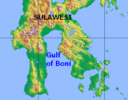
Gulf of Boni
Appearance
| Gulf of Boni/Bone | |
|---|---|
 Map of the Gulf of Boni | |
| Location | Sulawesi |
| Coordinates | 4°0′S120°45′E/ 4.000°S 120.750°E |
| Basincountries | Indonesia |
TheGulf of Boni[1](Indonesian:Teluk Bone), also known as theGulf of Bone,Bay of Boni,andBone Bay,is thegulfwhich divides theSouthandSoutheast Peninsulasof the island ofSulawesi(Celebes) inIndonesia.It opens on the south into theBanda Sea.[2]
Extent
[edit]TheInternational Hydrographic Organization(IHO) defines the Gulf of Boni (or Bone) as being one of the divisions of theEast Indian Archipelago.[3]It is defined as the waters north of the "line from Tanjung Lassa,Celebes,to the North point ofKabaenaIsland (5°05′S121°52′E/ 5.083°S 121.867°E) and thence up this meridian to the coast of Celebes ".[1]
See also
[edit]References
[edit]Citations
[edit]- ^abIHO (1953),§48 (k).
- ^IHO (1953),§48 (g).
- ^IHO (1953),§48.
Bibliography
[edit]- Limits of Oceans and Seas,3rd ed.(PDF),International Hydrographic Organization,1953, archived fromthe original(PDF)on 2018-10-05,retrieved29 December2020.

