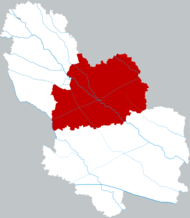
Guoyang County
Appearance
Guoyang
Oa dương huyện Kwoyang | |
|---|---|
 Location of Guoyang in Bozhou | |
| Country | People's Republic of China |
| Province | Anhui |
| Prefecture-level city | Bozhou |
| Area | |
| • Total | 2,107 km2(814 sq mi) |
| Population (2019) | |
| • Total | 1,319,000 |
| Time zone | UTC+8(China Standard) |
| Postal code | 233600 |
Guoyang County(simplified Chinese:Oa dương huyện;traditional Chinese:Oa dương huyện;pinyin:Guōyáng Xiàn) is a county in the northwest ofAnhui Province,China, borderingHenanprovince to the north. It falls under the administration ofBozhoucity.
Administrative divisions
[edit]In the present, Guoyang County has 4 subdistricts and 20 towns.[1]
- 4 subdistricts
- 20 towns
Climate
[edit]| Climate data for Guoyang (1991–2020 normals, extremes 1981–2010) | |||||||||||||
|---|---|---|---|---|---|---|---|---|---|---|---|---|---|
| Month | Jan | Feb | Mar | Apr | May | Jun | Jul | Aug | Sep | Oct | Nov | Dec | Year |
| Record high °C (°F) | 19.3 (66.7) |
26.4 (79.5) |
28.6 (83.5) |
33.2 (91.8) |
37.6 (99.7) |
40.0 (104.0) |
40.3 (104.5) |
38.2 (100.8) |
39.1 (102.4) |
35.5 (95.9) |
28.0 (82.4) |
21.7 (71.1) |
40.3 (104.5) |
| Mean daily maximum °C (°F) | 6.4 (43.5) |
9.9 (49.8) |
15.1 (59.2) |
21.6 (70.9) |
27.0 (80.6) |
31.6 (88.9) |
32.4 (90.3) |
31.0 (87.8) |
27.7 (81.9) |
22.6 (72.7) |
15.2 (59.4) |
8.6 (47.5) |
20.8 (69.4) |
| Daily mean °C (°F) | 1.5 (34.7) |
4.5 (40.1) |
9.5 (49.1) |
15.8 (60.4) |
21.3 (70.3) |
26.0 (78.8) |
27.9 (82.2) |
26.8 (80.2) |
22.6 (72.7) |
17.0 (62.6) |
9.9 (49.8) |
3.6 (38.5) |
15.5 (60.0) |
| Mean daily minimum °C (°F) | −2.2 (28.0) |
0.5 (32.9) |
4.9 (40.8) |
10.7 (51.3) |
16.1 (61.0) |
21.1 (70.0) |
24.3 (75.7) |
23.5 (74.3) |
18.6 (65.5) |
12.6 (54.7) |
5.8 (42.4) |
−0.2 (31.6) |
11.3 (52.4) |
| Record low °C (°F) | −13.9 (7.0) |
−13.7 (7.3) |
−7.6 (18.3) |
−1.4 (29.5) |
4.6 (40.3) |
11.8 (53.2) |
17.4 (63.3) |
14.7 (58.5) |
9.8 (49.6) |
−1.3 (29.7) |
−7.9 (17.8) |
−17.2 (1.0) |
−17.2 (1.0) |
| Averageprecipitationmm (inches) | 20.8 (0.82) |
24.7 (0.97) |
38.4 (1.51) |
46.4 (1.83) |
69.7 (2.74) |
127.4 (5.02) |
208.5 (8.21) |
143.1 (5.63) |
68.8 (2.71) |
55.3 (2.18) |
38.8 (1.53) |
18.6 (0.73) |
860.5 (33.88) |
| Average precipitation days(≥ 0.1 mm) | 5.1 | 6.3 | 6.7 | 7.0 | 8.1 | 8.1 | 11.9 | 11.7 | 8.4 | 6.6 | 6.6 | 4.7 | 91.2 |
| Average snowy days | 4.0 | 2.9 | 1.1 | 0 | 0 | 0 | 0 | 0 | 0 | 0 | 0.7 | 1.7 | 10.4 |
| Averagerelative humidity(%) | 67 | 66 | 66 | 68 | 69 | 67 | 78 | 81 | 75 | 68 | 68 | 67 | 70 |
| Mean monthlysunshine hours | 122.0 | 131.4 | 166.7 | 196.1 | 204.5 | 186.6 | 186.6 | 177.2 | 160.9 | 163.7 | 141.9 | 131.8 | 1,969.4 |
| Percentpossible sunshine | 39 | 42 | 45 | 50 | 47 | 44 | 43 | 43 | 44 | 47 | 46 | 43 | 44 |
| Source:China Meteorological Administration[2][3] | |||||||||||||
References
[edit]- ^Bạc Châu thị - khu hành chính hoa vương(in Chinese). XZQH.Retrieved2012-05-24.
- ^Trung Quốc khí tượng số liệu võng – WeatherBk Data(in Simplified Chinese).China Meteorological Administration.Retrieved27 June2023.
- ^ Trung Quốc khí tượng số liệu võng(in Simplified Chinese).China Meteorological Administration.Retrieved27 June2023.
33°30′31″N116°16′13″E/ 33.50861°N 116.27028°E
