
Haliacmon
| Haliacmon | |
|---|---|
 | |
| Native name | Αλιάκμονας(Greek) |
| Location | |
| Country | Greece |
| Physical characteristics | |
| Source | |
| • location | Pindusmountains |
| Mouth | |
• location | Aegean Sea |
• coordinates | 40°28′4″N22°39′15″E/ 40.46778°N 22.65417°E |
| Length | 297 km (185 mi) |
| Basin size | 8,813 km2(3,403 sq mi) |
TheHaliacmon(Greek:Αλιάκμονας,Aliákmonas;formerly:Ἁλιάκμων,AliákmonorHaliákmōn) is the longest river flowing entirely inGreece,with a total length of 297 km (185 mi).[1]In Greece there are three rivers longer than Haliakmon,Maritsa(Greek:Έβρος),Struma(Strymónas), both coming fromBulgaria,andVardar(Greek:Αξιός) coming fromNorth Macedonia,but the length of each one of them in Greek territory is less than that of Haliakmon, which flows entirely in Greece.Haliacmonis the traditional English name for the river, but many sources cite the formerly officialKatharevousaversion of the name,Aliákmon.Today, the onlyofficialvariant is thedemoticAliákmonas.It flows through the GreekregionsofWest Macedonia(Kastoria,GrevenaandKozaniregional units) andCentral Macedonia(ImathiaandPieriaregional units). Itsdrainage basinis 8,813 km2(3,403 sq mi).[2]
Name[edit]
The name (in Greek)Αλιάκμοναςis composite and derives fromάλας(salt, sea) andάκμων(anvil). InGreek mythologyHaliakmon was one of thePotamoi,who were sons ofOceanusandTethys,according to the allegorical obsessive-anthropomorphic concept familiar to theAncient Greeks,on geological upheaval afterDeucalion's deluge.
An ancient tradition says that sheep that drank water from Haliakmon would turn their colour to white. This tradition is confirmed by the following record of the Roman authorPliny the Elder(23-79 AD):Similarly in Macedonia, those who want their sheep to be white go to Haliakmon, while those (who want them to be) black (go) to Axios (Vardar).
Ottoman Turks called the river Ince-Karasu (narrow-black water), a name still used inTurkey.TheEastern South Slavicname is Бистрица,Bistritsa[3]which is still in use in Bulgaria and North Macedonia.[4][5][6]
Course and tributaries[edit]
Before the construction of its diversion dam near the village of Aghia Varvara in the mid-1950s, Haliakmon had no permanent river bed in its lowland course. It often flooded and formed extensivemarshes.Its devastating fury in December 1935 remains fresh in memory of the elder inhabitants of the region (VeriaandAlexandreia).
The Haliacmon rises in theGramosmountains in northern Greece, near the border withAlbania.In its upper course it flows generally towards the east, and turns southeast nearKastoria.It describes a wide curve around theVourinosmountains, and turns northeast near the villagePaliouria.It feeds the large artificiallake Polyfyto,that was created after the construction of the namesake hydroelectric dam and consists almost its entire course through the Kozani prefecture. Over the bridge runs theLake Polyfytos Bridge,part of theAthens-Kozani national road.Southeast ofVeria,the Haliacmon enters the central Macedonian plains, an area of great importance to agriculture. It flows into theThermaic Gulfwest of the delta of theAxios(Vardar), northeast of the coastal townMethoni.
Haliakmon's tributaries include Gramos, Ladopotamos, Pramoritsa, Grevenitikos, Venetikos and Tripotamos.


The Haliacmon flows along the towns (in downstream order)Nestorio,Argos Orestiko,Neapoli,Paliouria,VelventosandAlexandreia.
Wetland[edit]

Haliakmon contains 33 kinds of fish. These includebrown trout,gilt-head bream,sardine,carp,pike,eel,european anchovy,nursehound,bogue,garfish,red porgy,saddled seabream,angler,bream,mediterranean sand smelt,sand steenbras,mullus barbatus,freshwater bass,tuna,salmon,Mediterranean moray,weever,longfin gurnard,dogfish,dusky grouper,school sharkandturbot.About 30 of them are indigenous, while the rest were introduced by human intervention. Many of them are considered scarce and one,mavrotsironi,lives nowhere else in the world, i.e. it isendemic.Μost of these kinds of fish have no commercial value but only biological, since they support thefood web.Fish found in Haliakmon, likecarpandrainbow trout,indicate that its water is still pure. Some eels are found in its estuaries, that cannot migrate, hindered by the dams.
For amateur fishermen the river has been enriched with introduced rainbow trout, that is not easy to reproduce, so there is no danger of disturbance of the river'secosystem.
In the place where the river flows into the sea, there has been formed over the years an extendedDeltaof 4.000 hectares, because of the large dam that was constructed and retains much of the brought matters. As a result, silting has been greatly reduced and during the summer, when there is not much water, the sea enters and largely overwhelms the river bed.Flathead mulletsandEuropean seabassesare found in Haliakmon's Delta. In the shallow marine areas formed there, the fry of manyAegean Sea's fish finds a place to reproduce, while about 90% of Greece'smusselsare produced in the Haliakmon-Axios (Vardar) Delta. Aliki Kitrous is an area of 254 hectares, where 15–20.000 tons ofsaltare produced per year.
Many kinds of birds have been observed in Haliakmon's region. They use it for accommodation and overwintering, like theducks,or to rest on their long migratory journey. There have been observed 215 kinds of birds and about ⅓ of them nest in the region. Over 10% of the birds are endangered. They includeDalmatian pelicanandcurlew,that are considered to be among the rarest birds in the world. 27 kinds of rare and protected kinds of birds nest in the region, likepurple heron.
History[edit]
In antiquity,Claudius Ptolemycalled the chain of mountains in which the river rises (northernPindus) theCanalovii.According toJulius Caesar,the Haliacmon formed the line of demarcation betweenMacedonandThessaly.In the upper part of its course it took a southeast direction throughElimiotis,which it watered; and then, continuing to the northeast, formed the boundary betweenPieria,Eordaea,andImathia.In the time ofHerodotusthe Haliacmon was apparently joined by theLoudias7, 127,the discharge of the lake ofPella;but a change has taken place in the course of the Loudias, which no longer joins the Haliacmon, but flows directly into theAegean Sea.The image below shows awind gapbetween the Haliacmon and Loudiaswatershedsthat is the probable ancient course of the Haliacmon.
It was the domain of the eponymous river godHaliacmon.
Gallery[edit]
-
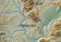 GIS map of Aliacmon
 -
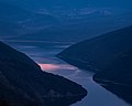
 View from above
 -
 The river near Sfikia


References[edit]
- ^Greece in Figures January - March 2018,p. 12
- ^"Preliminary Flood Risk Assessment"(in Greek). Ministry of Environment, Energy and Climate Change. p. 70. Archived fromthe originalon 15 February 2020.
- ^Мария Тодорова, Чужди пътеписи за Балканите. Том 7: Английски пътеписи за Балканите. Краят на XVI в. до 30-те години на XIX в. Сборник, Наука и изкуство, 1987, стр. 503-504. (Bulgarian).Maria Todorova,Foreign Travels for the Balkans. Volume 7: English travelogues for the Balkans. The End of the 16th Century to the 30s of the 19th Century; Collection, Science and Art, 1987, pp. 503-504.
- ^Encyclopedia of the Languages of Europe, Glanville Price, Blackwell Publishing, 2000,ISBN0-631-22039-9,p. 316.
- ^Die Jungtürken und die mazedonische Frage(1890-1918), Mehmet Hacısalihoğlu, Oldenbourg Wissenschaftsverlag, 2003,ISBN3-486-56745-4,s. 42.
- ^A History of the Crusades, Volume IV The Art and Architecture of the Crusader States, Kenneth M. Setton, Harry W. Hazard, Edition: University of Wisconsin Press, 1977,ISBN0-299-06824-2,p.368.
External links[edit]
![]() Media related toHaliacmonat Wikimedia Commons
Media related toHaliacmonat Wikimedia Commons
| National | |
|---|---|
| Geographic | |