Hazorasp
Hazara | |
|---|---|
Town | |
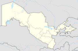
| Coordinates:41°19′N61°04′E/ 41.317°N 61.067°E | |
| Country | |
| Region | Xorazm Region |
| District | Hazorasp District |
| Population (2016) | |
| • Total | 18,800 |
| Time zone | UTC+5(UZT) |
Hazorasp(Uzbek:Hazorasp,Ҳазорасп), also known asKhazarasp(Russian:Хазарасп), or by its more ancient nameHazarasp(Persian:هزار اسپ,meaning"thousand horses"), is anurban-type settlementinUzbekistan,administrative centre of theHazorasp District.[1]Its population is 18,800 (2016).[2]It lies at the head of theAmu Daryadelta south of theAral Sea.
It was an important trading center during the medieval period. During its history, the town has been subject to various battles; between theGhaznavidSultanMahmud of Ghazniand theMa'munidrulerAbu'l-Harith Muhammadin 1017; between theSeljuqSultanAhmad Sanjarand theKhwarazmianrulerAtsizin 1147; and between the Khwarazmian rulerMuhammad IIand theGhuridrulerMu'izz al-Din Muhammad.The town was finally destroyed during theMongol invasions.
The town was later rebuilt, and only retained some of its importance. It was later a stronghold under theMongolArabshahids,and was also used as a residence by the Arabshahid princes. It was captured by the Russians during theKhivan campaign of 1873.The city has survived to present day, and is today a part of Uzbekistan. It was added to theUNESCOWorld HeritageTentative List in January 2008, in the Cultural category.[3]
References[edit]
- ^"Classification system of territorial units of the Republic of Uzbekistan"(in Uzbek and Russian). The State Committee of the Republic of Uzbekistan on statistics. July 2020.
- ^Soliyev, A.S.Shaharlar geografiyasi[Geography of cities](PDF)(in Uzbek). p. 174.
- ^"Khazarasp - UNESCO World Heritage Centre".UNESCO World Heritage Centre.Retrieved25 November2013.
Sources[edit]
- Luzac, & Co(1986). "The Encyclopedia of Islam".The Encyclopaedia of Islam, Vol. III.London: E.J. Brill. pp. 1–1304.
41°19′N61°04′E/ 41.317°N 61.067°E


