
Historic counties of Wales
| This article is part ofa serieswithin the Politics of the United Kingdomon the |
| Politics of Wales |
|---|
| Part ofa serieson the |
| Culture of Wales |
|---|
 |
| People |
| Art |
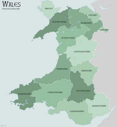
Thehistoric counties of Wales(Welsh:siroedd hynafol) were the thirteensub-divisionsused inWalesfrom either 1282 and 1535, up to their abolishment in 1974, being replaced byeight counties.They were used for various functions for several hundred years,[1]but for administrative purposes have been superseded by contemporarysub-national divisions,[2]some of which bear some limited similarity to the historic entities in name and extent. They are alternatively known asancient counties.[3]
The counties[edit]
-
County Welsh name Population (most recent)  Monmouthshire
Sir Fynwy34 503,917  Glamorganshire
Sir ForgannwgorMorgannwg1 1,288,309 Carmarthenshire Sir GaerfyrddinorSir Gâr2 187,568  Pembrokeshire
Sir Benfro1 125,055  Cardiganshire
Sir AberteifiorCeredigion2 72,992  Brecknockshire
Sir Frycheiniog3 43,376 Radnorshire Sir Faesyfed3 25,821 Montgomeryshire Sir Drefaldwyn3 63,779 Denbighshire Sir Ddinbych3 174,151  Flintshire
Sir y Fflint2 60,012  Merionethshire
Sir FeirionnyddorMeirionnydd2 38,310  Caernarfonshire
Sir Gaernarfon2 121,767  Anglesey
Sir Fôn2 69,961 -

- 1The earldom of Pembroke and lordship of Glamorgan pre-date theEdwardian conquest.
- 2These counties originate in 1282, following KingEdward I's conquest.
- 3These counties originate in 1535, with theLaws in Wales Act, 1535,converting the remainingMarcherLordships into counties.
- 4Despite being created at the same Act as the other counties, Monmouthshire was included with English counties for legal purposes until 1974. Between 1536 and 1974 the formulation "Wales and Monmouthshire" was frequently used.[4]
The 1535 Laws in Wales Act had the effect of abolishing themarcher lordshipswithin and on the borders of Wales. In the border areas, several were incorporated in whole or in part into English counties. The lordships ofLudlow,Clun,Causand part ofMontgomerywere incorporated into Shropshire; andWigmore,Huntington,Cliffordand most ofEwyaswere included in Herefordshire.[5]
The historic counties established by 1535 were used as the geographical basis for theadministrative counties,governed bycounty councils,which existed from 1889 to 1974. The historian William Rees said, in his "Historical Atlas of Wales": (published 1959) "... the boundaries of the modern shires have largely been determined by the ancient divisions of the country. The survival of these ancient local divisions within the pattern of historical change constitutes a vital element in the framework of the national life and helps to preserve its continuity."
Four circuits of Wales[edit]
In the 1536 acts of the Union, aCourt of Great Sessions in Waleswas created in Wales for four separate circuits. The circuits each had 3 counties involved. Some of the original territorialMarcher lordshipswere split into regional circuits and others were created from regions of the formerPrincipality of Wales:[6]
- Anglesey, Caernarfon & Merioneth
- Flint, Denbigh & Montgomery
- Cardigan, Carmarthen & Pembroke
- Radnor, Brecon & Glamorgan
Exclaves[edit]
TheCounties (Detached Parts) Act 1844abolished severalenclaves.One of these,Welsh Bicknor(Llangystennin) was an exclave ofMonmouthshirebetweenGloucestershireandHerefordshireand was transferred toHerefordshire.Two townships of the ancient parish ofCwmyoywere also exclaves of Herefordshire. Bwlch Trewyn was transferred to Monmouthshire, whereas the other, Ffwddog (identified using the English variant Fothock on older maps), was not.
The Herefordshire township of Litton and Cascob (in the parishes of Cascob and Presteigne), was transferred to Radnorshire.
The Denbighshire township ofCarreghofa(in the parish ofLlanymynech) was transferred to Montgomeryshire.
The exclaves ofFlintshire,calledEnglish MaelorandMarford and Hoseleywere left untouched.
Monmouthshire[edit]
The territory which became Monmouthshire was part of the Welsh kingdoms ofGwentandGlywysingand later, after the Norman conquest of southern Wales, of theWelsh Marches.Although the originalLaws in Wales Act 1535specifically stated the lands making up Monmouthshire were from the 'Country or Dominion of Wales', theLaws in Wales Act 1542added Monmouthshire to the Oxford circuit of the Englishassizesrather than falling under theCourt of Great Sessions in Wales.According to historianJohn Davies,this arrangement was the cause of the erroneous belief that the county had been annexed by England rather than remaining part of Wales.[7]In later centuries, some English historians, map-makers, landowners and politicians took the view that Monmouthshire was an English rather than a Welsh county, and references were often made in legislation to "Wales and Monmouthshire".The position was finally resolved by the Local Government Act 1972, which confirmed Monmouthshire's place within Wales.
Local government[edit]
1889[edit]
TheLocal Government Act 1888created a parallel system ofadministrative countiesbased on the historic counties in 1889. Additionally, certain boroughs were deemed to becounty boroughs,outside the administrative counties (CardiffandSwanseain 1889,Newportin 1891 andMerthyr Tydfilin 1908). As a result of 85 years of local government boundary changes, the boundaries of the administrative counties became increasingly different from the historic counties, until they were abandoned altogether for a different system of local government in 1974.
1974[edit]
TheLocal Government Act 1972replaced the administrative counties created in 1889 witheight new administrative countiesin 1974. The existingLieutenancyareas were also redefined to use the newly created local government areas, defined by the act as "counties." Furthermore, use of the historic counties aspostal countieswas stopped by theRoyal Mailin 1975 and those historic counties were no longer shown on maps. However, in spite of widespread misunderstanding, the Local Government Act 1972 never abolished the historic counties. Indeed, the Department of the Environment made this very clear in a statement it issued on 1 April 1974:
"The new county boundaries are solely for the purpose of defining areas of...local government. They are administrative areas, and will not alter the traditional areas of Counties (the historic counties), nor is it intended that the loyalties of people living in them will change."
The eight new administrative counties were themselves replaced in 1996 by the currentprincipal areas of Wales,but modified versions were retained for Lieutenancy as thepreserved counties.
Vice counties[edit]
Thevice counties,used for biological recording throughout Great Britain and Ireland since 1852, are largely based on historic county boundaries. They ignore all exclaves and are modified by subdividing large counties and merging smaller areas into neighbouring counties. The static boundaries makelongitudinal studyof biodiversity easier.
Index of Place Names[edit]
The historic counties of Wales are included in theIndex of Place Names(IPN) published by theOffice for National Statistics.Each "place" included in the IPN is related to the historic county it lies within, as well as to a set of administrative areas. The Historic Counties Trust has published demographic statistics for the historic counties of the UK from the2011 United Kingdom censusincluding a comparison of population and population density in the historic counties of England and Wales between the1901 United Kingdom censusand the2011 United Kingdom censusand a comparison of the number of Welsh speakers in the historic counties of Wales between the1911 United Kingdom censusand the2011 United Kingdom census.[8]
References[edit]
- ^Bryne, T.,Local Government in Britain,(1994)
- ^Her Majesty's Stationery Office,Aspects of Britain: Local Government,(1996)
- ^Vision of Britain– Type details for ancient county. Retrieved 19 October 2006.
- ^Statute Law database: "Wales and Monmouthshire" search results
- ^John Davies,A History of Wales,Penguin, 1993,ISBN0-14-028475-3
- ^Williams, Philip Nanney (2016).Nannau - A Rich Tapestry of Welsh History.Llwyn Estates Publications. p. 64.ISBN978-0-9955337-0-7.
- ^John Davies,A History of Wales,1993,ISBN0-14-028475-3
- ^Historic Counties TrustThe Demography of the Historic CountiesRetrieved 15 June 2020
External links[edit]
- The Historic Counties Trust
- Campaign for Historic Counties
- Interactive map of the historic counties
- Family history links to historic counties of Wales
 | ||
| Physical | |||||||
|---|---|---|---|---|---|---|---|
| Environment | |||||||
| Land use | |||||||
| Administrative |
| ||||||
| Social | |||||||
| Other | |||||||