
Hron
| Hron | |
|---|---|
 The Hron nearStarý Tekov | |
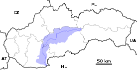  Current and watershed of the Hron River in Slovakia | |
| Location | |
| Country | Slovakia |
| Region | Banská Bystrica,Nitra |
| Physical characteristics | |
| Source | Hron |
| • location | Kráľova hoľanearTelgárt |
| • elevation | 980 m (3,220 ft) |
| Mouth | Danube |
• location | Kamenica nad Hronom,Nitra Region |
• elevation | 112 m (367 ft) |
| Length | 271 km (168 mi) |
| Basin size | 5,465 km2(2,110 sq mi) |
| Discharge | |
| • average | 53.7 m3/s (1,900 cu ft/s) |
| • minimum | 7.6 m3/s (270 cu ft/s) |
| • maximum | 1,050 m3/s (37,000 cu ft/s) |
| Basin features | |
| Progression | Danube→Black Sea |
| Tributaries | |
| • left | Slatina |
| • right | Zákruty |
TheHron(Slovak:Hron;German:Gran;Hungarian:Garam;Latin:Granus) is a 271-kilometre (168 mi) long left tributary of theDanube[1]and the second-longest river inSlovakia.It flows from its source in theLow TatraMountains (belowKráľova hoľa) through central and southern Slovakia, emptying into the Danube nearŠtúrovoandEsztergom.Major cities and towns on the Hron areBrezno,Banská Bystrica,Sliač,Zvolen,Žiar nad Hronom,Žarnovica,Nová Baňa,Tlmače,Levice,Želiezovce,and Štúrovo.
The river's basin covers 5,465 km2(2,110 sq mi),[1]which is approximately 11 percent of Slovakia's territory.
Hron is a popular destination ofwater tourism.
Etymology
[edit]The name is probably of Germanic origin;*Granahua:gran– spruce,ahua– water.[2]
History
[edit]The name of the river was mentioned for the first time in 170, whenRoman EmperorMarcus Aureliuswrote hisMeditationsat the Hron (Latin:Granus) river.[3]The first recorded medieval name was Gron (1075).[3]From the 17th century until the 1930s, the river was used for wood transport.
References
[edit]- ^abPlán manažmentu povodňového rizikavčiastkovom povodí Hrona,p. 38
- ^Krško, Jaromír (2008).Hydronymia povodia Hrona(in Slovak). Banská Bystrica: Univerzita Mateja Bela. p. 81.ISBN978-80-8083-611-5.
- ^abKrško, Jaromír (June 2003). "Názvy potokov v Banskej Bystrici a okolí".Bystrický Permon.1(2): 8.
| Countries |  | |
|---|---|---|
| Cities | ||
| Tributaries | ||
| Canals | ||
| See also | ||
Hydrography ofSlovakia | ||||||||||||
|---|---|---|---|---|---|---|---|---|---|---|---|---|
| Rivers |
|  | ||||||||||
| Lakes |
| |||||||||||
| Reservoirs |
| |||||||||||
| River islands | ||||||||||||
| International | |
|---|---|
| National | |
47°49′N18°45′E/ 47.817°N 18.750°E