Humen
| Humen | |||||||||||||
|---|---|---|---|---|---|---|---|---|---|---|---|---|---|
 View of theHumen Bridgeover the strait | |||||||||||||
| Traditional Chinese | Hổ môn | ||||||||||||
| Simplified Chinese | Hổ môn | ||||||||||||
| Postal | Hu-mun | ||||||||||||
| Literal meaning | The Tiger Gate | ||||||||||||
| |||||||||||||
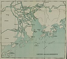
TheHumen,also known as theBocca Tigrisor theBogue,is a narrowstraitin thePearl River Deltathat separatesShiziyangin the north andLingdingyangin the south. It is located nearHumen Townin China'sGuangdongProvince. It is the site of thePearl River's discharge into theSouth China Sea.It contains thePort of Humenat Humen Town. The strait is formed by the islands of Chuenpi (Xỏ mũi,pChuanbi) and Anunghoy (Mẹ giày,pAniangxie;also calledUy xa,pWeiyuan) on the eastern side, and Taikoktow ( đại đầu đảng,pDajiaotou) on the western side.[1]Since 1997, the strait has been traversed by theHumen Pearl River Bridge.Bocca Tigris was the entry to China's only trading city,Canton.
Name
[edit]TheLatinateBocca Tigrisis derived from thePortugueseBoca do Tigre,which is acalqueof theMandarin ChineseandCantonesenameHổ môn,literally meaning "The Tiger Gate".[2]The nameBogueis also a corruption of the PortugueseBoca.[2]
The name comes from the impression given by Tiger Island, situated about 3.2 km (2.0 mi) above the Hengdang Islands in the middle of the strait, of a tiger couchant[3]or at least of a tiger's head on its eastern side.[4][5][6]American CommodoreMatthew Perry,who later played a leading role in theopening of Japanto the West, noted that: "Although the resemblance is not at first very striking, it becomes quite obvious after examination".[4]
History
[edit]

Because of its strategic location as the naval gateway to the city ofGuangzhou(Canton), the strait was strongly fortified during theQing dynasty.It was defended by eight forts: Shakok (Shajiao), Taikok (Dajiao), Wangtung (Hengdang), Yung-an (Yong'an), Kung-ku (Gonggu), Chen-yuan (Zhenyuan), Ching-yuan (Jingyuan), andWei-yuan.[7]Between September 1809 and January 1810,Portuguese Navyships based inMacaudefeated a group of Chinese pirates in theBattle of the Tiger's Mouth.
The first major battle of theFirst Opium Warbetween the United Kingdom and China occurred at the entrance of the Humen in theFirst Battle of Chuenpion 3 November 1839. The British captured the Bogue forts in theSecond Battle of Chuenpion 7 January 1841 and theBattle of the Bogueon 23–26 February. The forts were recaptured on 2 April 1847 during the BritishExpedition to Canton.In theSecond Opium War,the British recaptured the forts in the1856 Battle of the Bogueon 12–13 November.
Geography
[edit]- Eastern shore:Humen TowninDongguanCity
- Western shore: theNansha Districtof Guangzhou City
- Upper and Lower Hengdang Islands (Hoành đương đảo), or North and South Wangtong Islands, in the middle of the strait
- Humen Pearl River Bridge
- Several Qing dynasty forts, including:
- Weiyuan Fort(Uy xa pháo đài), near Humen Town
- Shajiao Fort (Sa giác pháo đài), in Humen Town
- Nansha Pier (Tân Nam Sa vận chuyển hành khách cảng), in the Nansha District, 1.6 km (0.99 mi) south of the Humen Bridge
Port of Humen
[edit]The Port of Humen at Humen Town serves as the port of the industrial city of Dongguan and as one of the big logistic hubs of the Pearl River Delta. It extends on the east shore of the delta beyond the strait all the way to theDong gian g River.It is divided into five port areas:
- Shatian Port Area (Ruộng cát cảng khu): focuses on containers, chemicals, yard logistics, shoreline industry, and comprehensive trading services.
- Mayong Port Area (Ma dũng cảng khu): focuses on grain, vegetable oil, coal, construction materials, andbreak-bulkcargo.
- Shajiao Port Area (Sa giác cảng khu): focuses on passenger transport, leisure boating, and coastal transport and cabotage.
- Chang'an Port Area (Trường An cảng khu): focuses on large-scale deep-water berths and the waterfront industry.
- Neihe Port Area (Nội hà cảng khu): focuses on traditional waterborne transport services for the Dongguan industries.
The port has 72 km2(28 sq mi) of territorial waters and 32 km2(12 sq mi) of jurisdictional area. The main navigation channel is 13.5 m (44 ft) deep, enough for vessels of 100,000 DWT.[8]Originally called Taiping port, theState Councilapproved it as an open port in 1983. It was merged with the Shatian port in June 1997 and renamed Humen port.[9]
See also
[edit]- Treaty of the Bogue(1843)
Notes
[edit]- ^Bingham, J. Elliot (1843).Narrative of the Expedition to China from the Commencement of the War to Its Termination in 1842(2nd ed.). Volume 2. London: Henry Colburn. p. 3.
- ^abTaylor 1898, p. 70
- ^Wathen, James (1814).Journal of a Voyage, in 1811 and 1812, to Madras and China.London: J Nichols, Son and Bentley. p. 177.
- ^abHawks, Francis L.; Perry, Matthew (1857).Narrative of the Expedition of an American Squadron to the China Seas and Japan.New York: D. Appleton and Company. p. 161.
- ^Taylor 1898, p. 277
- ^Bernard, William Dallas; Hall, William Hutcheon (1846).The Nemesis in China(3rd ed.). London: Henry Colburn. p. 81.
- ^Waley, Arthur(1958).The Opium War Through Chinese Eyes.Woking, Surrey: George Allen and Unwin.ISBN0049510126.pp. 130, 139.
- ^"Cảng khu tình hình chung - Trung Quốc · hổ môn cảng".Archived fromthe originalon 2014-06-03.Retrieved2016-07-24.
- ^Yeung, Godfrey (2001).Foreign Investment and Socio-Economic Development: The Case of Dongguan.New York: Palgrave. p. 97.ISBN9780333978115.
References
[edit]- Taylor, Isaac (1898).Names and Their Histories: A Handbook of Historical Geography and Topographical Nomenclature(2nd ed.). London: Rivingtons.
External links
[edit]- Satellite view of Bocca Tigris on Google maps
 Tiger Island., painted byClarkson Frederick Stanfieldand engraved byEdward Goodallfor Fisher's Drawing Room Scrap Book, 1832, with a poetical illustration byLetitia Elizabeth Landon,The Pirate's Song off Tiger Island.
