
Ili River
| Ili River | |
|---|---|
 Ili River | |
 Map of theLake Balkhashdrainage basin showing the Ili River and its tributaries, the Kash mistranscribed as 'Kax' | |
| Location | |
| Country | KazakhstanandChina |
| Physical characteristics | |
| Source | |
| • location | Tekes andKünesrivers |
| • elevation | Tian Shan |
| Mouth | |
• location | Lake Balkhash |
| Length | 1,439 km (894 mi) |
| Basin size | 140,000 km2(54,000 sq mi) |
| Discharge | |
| • average | 480 m3/s (17,000 cu ft/s) |
| Official name | Ili River Delta and South Lake Balkhash |
| Designated | 1 January 2012 |
| Reference no. | 2020[1] |
TheIli River(Uyghur:ئىلى دەرياسى,Или Дәряси,Ili Dəryasi;Kazakh:Ile;Russian:Или;Chinese:Y lê hà,Yīlí Hé;Dungan:Йили хә,اِلِ حْ;Mongolian:Или мөрөн,Ili Mörön) is ariverinNorthwest Chinaand SoutheasternKazakhstan.It flows from theIli Kazakh Autonomous Prefectureof theXin gian g Uighur Autonomous Regionto theAlmaty Regionin Kazakhstan.
It is 1,439 kilometres (894 mi) long (including its source river the Tekes),[2]815 kilometres (506 mi) of which is in Kazakhstan. The river originates from the Tekes andKünesrivers in EasternTian Shan.The Ili drains the basin between the Tian Shan and theBorohoro Mountains.Flowing intoLake Balkhash,the Ili forms a largedeltawith vast wetland regions of lakes, marshes and vegetation.[3][4]
Name[edit]
The river's name is usually taken to derive fromMongolianil(ил,"open, clear, obvious" ) in reference to its wide central valley.[5]It is also variously derived fromPersianorIranianterms[which?]meaning "big river" or "murky" in reference to the water's condition at the confluence of the Kunges and Tekes.[5]SomeUyghurscholars derive it from Uyghuril( "hook" )[citation needed]after the supposed similarity in the river's shape.[6]Tourist websites sometimes claim the name descends from a Mongolian word meaning "shimmering".[7]
Mentions ofIliriver can be traced back to theMahmud al-Kashgari's dictionary of Turkic languages, theDīwānu l-Luġat al-Turk(written in 1072–74). In the book, the author defines it in the following way: "Ili, the name of a river. Turkic tribes ofYaghma,TokhsiandChigliglive on its banks. Turkish countries regard the river as their Jayhoun (Amu Darya). "[8]
Chinese region[edit]

The upper Ili Valley is separated from theDzungarian Basinin the north by the Borohoro Mountains, and from theTarim Basinin the south by theTian Shan.This region was the stronghold of theQingadministration in Xin gian g in the late 18th and 19th centuries. It was occupied by Russia from 1871 to 1881 (from theYaqub Begrebellion until theTreaty of Saint Petersburg (1881)).
Presently, the region forms part of Xin gian g'sIli Kazakh Autonomous Prefecture.The main city of the region,Yining(Kulja), is located on the northern side of the river (about 100 kilometres (62 mi) upstream from the international border). Until the early 1900s, the city was commonly known under the same name as the river,Y lê(Pinyin:Yīlí;Wade-Giles:Ili).Qapqal Xibe Autonomous Countyin located on the southern side, which is home to many of China'sXibe people(who resettled there in the 18th century as part of the Manchu Garrison).
There are at least two dams on the Ili's tributary, the Kash River (Khách Thập hà), inNilka County,at43°51′40″N82°50′52″E/ 43.86111°N 82.84778°Eand 43°51′14″N82°48′08″E/ 43.85389°N 82.80222°E.At least two dams have been constructed on the Ili's left tributary, the Tekes River, and the Qiapuqihai Hydropower Station (Đúng lúc phủ này nước biển trạm phát điện) inTokkuztara County(43°18′14″N82°29′05″E/ 43.30389°N 82.48472°E). There is also another smaller dam at43°23′41″N82°29′20″E/ 43.39472°N 82.48889°E,on the border of Tokkuztara andKünesCounties.
Kazakh region[edit]

The Ili is the main watercourse of theBalkhash-Alakol Basin.The region of Kazakhstan partially drained by the Ili and its tributaries is known in Kazakh asZhetysu('Seven Rivers'). In Russian it is known asSemirechye(meaning the same).
TheKapshagay Hydroelectric Power Plantwas constructed between 1965 and 1970 nearKapchagayin the middle reaches of the Ili River.[9]This currently comprises theKapchagay Reservoir,an artificial 110 kilometres (70 mi) long lake north ofAlmaty.
The Tamgaly-Tas, a protected site that comprisesrock drawings,is located 20 kilometres (12 mi) downstream along the Ili River. The nameTamgalyinKazakhmeans "painted" or "marked place", andTasmeans "stone".
Ili Delta[edit]

The Ili River flows into the southeastern edge ofLake Balkhash,where it forms a large delta of about 8,000 square kilometres (3,100 sq mi). The delta is situated between theSaryesik-Atyrau Desertand the Taukum Desert. An area of 9,766 km2(3,771 sq mi) within the delta has been designated as aRamsar Site.This site has 427 species of plants and 345 species of animals, including important populations of rare species (Dalmatian pelican,goitered gazelle,marbled polecat,white-headed duck,red-breasted goose,ship sturgeon,and others).[1]The delta has also become popular amongst anglers for itswels catfish,which can grow up to over 300 lb (140 kg). The Ili river ranks third inKazakhstanafter theIrtysh riverand the Ural river in terms of water content.
The Government of Kazakhstan plans[as of?]to join the three sanctuaries Balkash, Karoy and Kukan (situated in the delta) into one National Park.[10]Until 1948, the delta was a refuge of the extinctCaspian tiger.Anintroductionof theSiberian tigerto the delta has been proposed on account that it is a genetically close relative of the Caspian tiger. A large population ofwild boar,the main prey base of the Caspian tiger, can be still[when?]found in the delta. There is also a small population of roe deer. In the drier steppes to the south of the delta livesaiga antelopesandgoitered gazelles.
Reintroduction of theBactrian deer,another prey of the Caspian tiger, is currently[when?]under consideration. Another potential prey species considered to be reintroduced is theAsiatic wild ass.[11]
Historical connections[edit]
The Ili River treaty of 638 AD formalized the division of theWestern Turkic Kaganate(552–638 AD) into theNushibiand theDulu.It also established the Ili River as the border between the two states.[12]In the 21st century, increasing need for water in both China and Kazakhstan makes the management of the cross-border Ili River a topic of concern for environmentalists and politicians in Kazakhstan (who feel that their country may not get enough water flowing in from China any more).[13]
The amount of precipitation in summer reaches 150–250 cubic metres (5,300–8,800 cu ft).[citation needed]
Fishing[edit]
On the river, the most popular type of fishing is fishing of catfish, one of the largest aquatic predators, which may reach 5 meters (16 ft) in length and weigh up to 300 kilograms (660 lb). Smaller specimens are usually within 50–100 kilograms (110–220 lb).
Gallery[edit]
-
 Ili River
 -
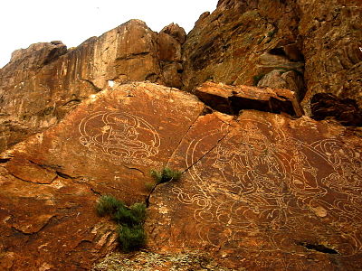 Buddhist rock drawings at Ili River
 -
 Ili River
 -
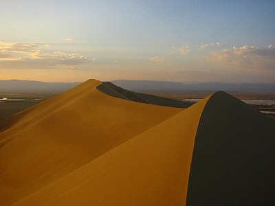 The "singing dune" atAltyn-Emel National Park


Tributaries[edit]
The main tributaries of the Ili are, from source to mouth:[2]
References[edit]
Citations[edit]
- ^ab"Ili River Delta and South Lake Balkhash".RamsarSites Information Service.Retrieved25 April2018.
- ^abИли,Great Soviet Encyclopedia
- ^Ili River
- ^Ili river Kazakhstan
- ^abBorlykova & Menyaev (2022),pp. 111–112.
- ^Arup, Adil (2007), "Ili Atalghusi Heqqide" [Etymology of 'Ili'],Journal of Ili Darya(in Uyghur).
- ^"Ili River",Altyn-Emel,Basshi:Arba Travel, 2024.
- ^Kashgari, Mahmud (1072–1074).Dīwānu l-Luġat al-Turk[Compendium of the languages of the Turks]. Vol. I. p. 124.
- ^Kezer, K.; Matsuyama, H. (2006). "Decrease of river runoff in the Lake Balkhash basin in Central Asia".Hydrological Processes.20(6): 1407–1423.Bibcode:2006HyPr...20.1407K.doi:10.1002/hyp.6097.S2CID128565175.
- ^"Kazakhstan names large inland delta]".WWF Russia(Press release). 2 February 2012. Archived fromthe originalon 1 April 2017.
- ^Jungius, Hartmut (2010).Feasibility Study on the Possible Restoration of the Caspian Tiger in Central Asia(Report). WWF Russia. Archived fromthe originalon 17 November 2011.
- ^Zuev, Yu. L. (2004).The strongest tribe.Almaty. pp. 55–56.
{{cite book}}:CS1 maint: location missing publisher (link) - ^Stone, Richard (27 July 2012). "For China and Kazakhstan, No Meeting of the Minds on Water".Science.337(6093): 405–407.Bibcode:2012Sci...337..405S.doi:10.1126/science.337.6093.405.PMID22837504.
Bibliography[edit]
- Borlykova, Boskha Kh.; Menyaev, Badma V. (2022)."Towards the Study of Oirat Hydronyms of the Ili River".Voprosy OnomastikiВопросы Ономастики[Problems in Onomastics] (in Russian).19(2). Ekaterinburg: Ural Federal University: 104–126.doi:10.15826/vopr_onom.2022.19.2.019.
- Или, река Семиречинской области(The Ili River), inBrockhaus and Efron Encyclopedic Dictionary
| Yangtzesystem | |
|---|---|
| Yellowsystem | |
| Pearlsystem | |
| Heilong gian gsystem | |
| Huaisystem | |
| Haisystem | |
| Liaosystem | |
| Other major rivers |
|
| Major canals | |
| International | |
|---|---|
| National | |