Indijk, Súdwest-Fryslân
Appearance
Indijk
Yndyk | |
|---|---|
Village | |
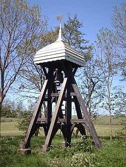
 Indijk bellfray | |
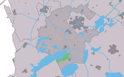
 Location in the former Wymbritseradiel municipality | |
| Coordinates:52°56′49″N5°36′7″E/ 52.94694°N 5.60194°E | |
| Country | |
| Province | |
| Municipality | |
| Area | |
• Total | 7.91 km2(3.05 sq mi) |
| Elevation | 0.1 m (0.3 ft) |
| Population (2021)[1] | |
• Total | 115 |
| • Density | 15/km2(38/sq mi) |
| Postal code | 8553[1] |
| Dialing code | 0514 |
Indijk(West Frisian:Yndyk) is a village in the northernNetherlands.It is located inSúdwest-Fryslânmunicipality,Frieslandand had a population of around 105 in January 2017.[3]
History
[edit]The village was first mentioned in 1449 as Indyck, and means "interiordike.[4]Indijk developed in the late middle ages along the Ee river.[5]
In 1497, the church was burned down by soldiers. In 1520, the village was destroyed bySchieringers.A new church was built, but had turned into a ruin by 1720, and was later demolished. A belfry was placed on the cemetery instead. In 1949, it was destroyed by a sorm and rebuilt in 1956.[5]
Indijk was home to 65 people in 1840.[6]Before 2011, the village was part of theWymbritseradielmunicipality.[6]
References
[edit]- ^abc"Kerncijfers wijken en buurten 2021".Central Bureau of Statistics.Retrieved6 April2022.
- ^"Postcodetool for 8553MC".Actueel Hoogtebestand Nederland(in Dutch). Het Waterschapshuis.Retrieved6 April2022.
- ^Kerncijfers wijken en buurten 2017- CBS Statline
- ^"Indijk".Etymologiebank(in Dutch).Retrieved6 April2022.
- ^ab"Indijk".Friesland wonderland(in Dutch).Retrieved6 April2022.
- ^ab"Indijk (Woudsend)".Plaatsengids(in Dutch).Retrieved6 April2022.
Wikimedia Commons has media related toIndijk, Súdwest-Fryslân.


