
Istočna Ilidža
Istočna Ilidža
Источна Илиџа East Ilidža | |
|---|---|
 Istočna Ilidža | |
 Coat of arms | |
 Location of Istočna Ilidža within Bosnia and Herzegovina | |
 | |
| Coordinates:44°15′N18°41′E/ 44.250°N 18.683°E | |
| Country | |
| Entity | |
| City | |
| Government | |
| • Municipal mayor | Marinko Božović (SDS) |
| • Municipality | 27.9 km2(10.8 sq mi) |
| Population (2013 census) | |
| • Town | 14,241 |
| • Municipality | 14,763 |
| • Municipality density | 530/km2(1,400/sq mi) |
| Time zone | UTC+1(CET) |
| • Summer (DST) | UTC+2(CEST) |
| Area code | 57 |
Istočna Ilidža(Serbian Cyrillic:Источна Илиџа,lit."East Ilidža" ) is a municipality in the city ofIstočno Sarajevo,Republika Srpska,Bosnia and Herzegovina.As of 2013, it has a population of 14,763 inhabitants.
It was also known asSrpska Ilidža(Српска Илиџа, "Serbian Ilidža" ), as well asKasindo,and was created from part of the pre-war municipality ofIlidža(the other part of the pre-war municipality is now in theFederation of Bosnia and Herzegovina). There have been some proposals for the municipality to be merged with that ofIstočno Novo Sarajevo.[1]
Demographics
[edit]Population
[edit]| Population of settlements – Istočna Ilidža municipality | |||
|---|---|---|---|
| Settlement | 1991. | 2013. | |
| Total | 16,754 | 14,763 | |
| 1 | Kasindo / Врдољ | 911 | 539 |
| 2 | Krupac / Лепуван | 232 | |
Ethnic composition
[edit]| Ethnic composition – Istočna Ilidža municipality | |||||||
|---|---|---|---|---|---|---|---|
| 2013. | |||||||
| Total | 14.763 (100,0%) | ||||||
| Serbs | 13.755 (93,17%) | ||||||
| Bosniaks | 648 (4,389%) | ||||||
| Others | 204 (1,382%) | ||||||
| Croats | 156 (1,057%) | ||||||
Sport
[edit]The localfootball clubisFK Famos,which competes in the First League of theRepublika Srpska.
Gallery
[edit]-
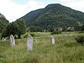 Stećciin Krupac necropolis
 -
 Parts of the modern-day city during theBosnian war
 -
 Remains of prehistoric fort, late antiquity fort wall pieces and church foundations from the same time period
 -
 New buildings
 -
 Serbian Orthodox church


References
[edit]- ^"Glas Srpske".Archived fromthe originalon 2007-09-27.Retrieved2006-10-29.
External links
[edit]
 | |||||||||||||||
This article about a location in themunicipalityofIstočna Ilidža,Republika Srpskais astub.You can help Wikipedia byexpanding it. |