
Istočni Stari Grad
Istočni Stari Grad
Источни Стари Град East Old Town | |
|---|---|
 Coat of arms | |
 Location of Istočni Stari Grad within Bosnia and Herzegovina | |
 | |
| Coordinates:43°51′22″N18°29′00″E/ 43.85611°N 18.48333°E | |
| Country | |
| Entity | |
| City | |
| Government | |
| • Municipal mayor | Bojo Gašanović (SDS) |
| Area | |
| • Total | 69.84 km2(26.97 sq mi) |
| Population (2013 census) | |
| • Total | 1,131 |
| • Density | 16/km2(42/sq mi) |
| Time zone | UTC+1(CET) |
| • Summer (DST) | UTC+2(CEST) |
| Area code | 57 |
| Website | www |

Istočni Stari Grad(Serbian Cyrillic:Источни Стари Град,lit."East Old Town" ) is a municipality of the city ofIstočno Sarajevolocated inRepublika Srpska,Bosnia and Herzegovina.As of 2013, it has a population of 1,131 inhabitants.
It was also known asSrpski Stari Grad(Српски Стари Град, "Serbian Old Town" ) and was created from part of the pre-war municipality ofStari Grad(the other part of the pre-war municipality is now in theFederation of Bosnia and Herzegovina).[1]The seat of municipality isHreša.
Demographics
[edit]Population
[edit]| Population of settlements – Istočni Stari Grad municipality | |||
|---|---|---|---|
| Settlement | 1991. | 2013. | |
| Total | 1,131 | ||
| 1 | Bulozi | 278 | 258 |
| 2 | Vučja Luka | 256 | |
Ethnic composition
[edit]| Ethnic composition – Istočni Stari Grad municipality | |||||||
|---|---|---|---|---|---|---|---|
| 2013. | |||||||
| Total | 1,131 (100,0%) | ||||||
| Serbs | 1,071 (94,69%) | ||||||
| Bosniaks | 43 (3,802%) | ||||||
| Others | 10 (0,884%) | ||||||
| Croats | 7 (0,619%) | ||||||
Gallery
[edit]-
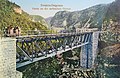 Bridge built during the Austro-Hungarian rule
 -
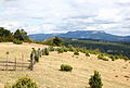 Romanija
 -
 Hreša
Hreša -
 Trebević
 -
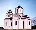 Serbian Orthodox church


References
[edit]- ^"Историја – Општина Источни Стари Град"(in Serbian).Retrieved2021-01-18.
External links
[edit]Wikimedia Commons has media related toIstočni Stari Grad.

 | |||||||||||||||