
Iwate Prefecture
Iwate Prefecture
Nham tay huyện | |
|---|---|
| Japanese transcription(s) | |
| •Japanese | Nham tay huyện |
| •Rōmaji | Iwate-ken |
 Symbol | |
| Anthem:Iwate kenmin no uta | |
 | |
| Country | |
| Region | Tōhoku |
| Island | Honshu |
| Capital | Morioka |
| Subdivisions | Districts:10,Municipalities:33 |
| Government | |
| •Governor | Takuya Tasso |
| Area | |
| • Total | 15,275.01 km2(5,897.71 sq mi) |
| • Rank | 2nd |
| Population (July 1, 2023) | |
| • Total | 1,165,886 |
| • Rank | 32nd |
| • Density | 76/km2(200/sq mi) |
| • Dialects | Nanbu・Southern Iwate (Kesen) |
| GDP | |
| • Total | JP¥4,848 billion US$44.5 billion (2019) |
| ISO 3166 code | JP-03 |
| Website | www |
| Symbols of Japan | |
| Bird | Green pheasant(Phasianus colchicus) |
| Fish | Chum salmon(Oncorhynchus keta) |
| Flower | Paulowniatree (Paulownia tomentosa) |
| Tree | Nanbu red pine(Pinus densiflora) |


Iwate Prefecture(Nham tay huyện,Iwate-ken)is aprefecture of Japanlocated in theTōhoku regionofHonshu.[2]It is the second-largest Japanese prefecture at 15,275 square kilometres (5,898 sq mi), with a population of 1,165,886 (as of July 1, 2023). Iwate Prefecture bordersAomori Prefectureto the north,Akita Prefectureto the west, andMiyagi Prefectureto the south.
Moriokais the capital and largest city of Iwate Prefecture; other major cities includeIchinoseki,Ōshū,andHanamaki.[3]Located on Japan'sPacific Oceancoast, Iwate Prefecture features the easternmost point of Honshu atCape Todo,and shares the highest peaks of theŌu Mountains—the longestmountain rangein Japan—at the border with Akita Prefecture. Iwate Prefecture is home to famous attractions such asMorioka Castle,theBuddhisttemples ofHiraizumiincludingChūson-jiandMōtsū-ji,the Fujiwara no Satomovie lotandtheme parkin Ōshū, and the Tenshochi park inKitakamiknown for its huge, ancientcherry trees.Iwate has the lowestpopulation densityof any prefecture outsideHokkaido,5% of its total land area having been designated asNational Parks.
Name[edit]
There are several theories about the origin of the name "Iwate", but the most well known is the taleOnino tegata,which is associated with the Mitsuishi or "Three Rocks" Shrine in Morioka. These rocks are said to have been thrown down into Morioka by an eruption of Mt. Iwate. According to the legend, there was once a devil who often tormented and harassed the local people. When the people prayed to the spirits of Mitsuishi for protection, the devil was immediately shackled to these rocks and forced to make a promise never to trouble the people again.[4]As a seal of his oath, the devil made a handprint on one of the rocks, thus giving rise to the name Iwate, its direct translation being "rock hand". Even now after a rainfall, it is said that the devil's hand print can still be seen there.
Culture[edit]
There are many present-day cultural foods popularly eaten in Iwate Prefecture, some of which includewalnuts,wanko soba(meaning "bowl noodles" ) and hittsumi-jiru (meaning "pull and tear", in reference to the way the dough is pulled and torn into oval shapes before being turned into noodles).[5]Iwate's prefectural capitalMoriokais also popular for its apples, blooming in May and ready forharvestfrom September to November.[6]
Japanese poetMatsuo Bashōvisited Iwate and wrote about it in the journey described in his major workOku no Hosomichi.He was especially inspired by the town ofHiraizumi.
History[edit]
While the entire island of Honshū was claimed by the Japanese, or Yamato, government from earliest times as a sort of divine right or manifest destiny, the imperial forces were unable to occupy any part of what would become Iwate until 802 when two powerfulEmishileaders,Ateruiand More, surrendered at Fort Isawa.
The area now known as Iwate Prefecture was inhabited by theJōmonpeople who left their artifacts throughout the prefecture. For example, a large number of burial pits from the Middle Jōmon Period (2,800–1,900 BC) have been found in Nishida. Various sites from the Late Jōmon Period (1,900–1,300 BC) including Tateishi, Makumae and Hatten contain clay figurines, masks and ear and nose shaped clay artifacts. The Kunenbashi site in Kitakami City has yielded stone "swords", tablets and tools as well as clay figurines, earrings and potsherds from the Final Jōmon Period (1,300–300 BC).
The earliest mention of a Japanese presence dates to about 630 when the Hakusan Shrine was said to have been built on Mt. Kanzan in what is now Hiraizumi. At this time various Japanese traders, hunters, adventurers, priests and criminals made their way to Iwate. In 712 the province ofMutsu,containing all ofTōhoku,was divided intoDewa Province,the area west of theOu Mountainsand Mutsu Province. In 729 Kokuseki-ji Temple was founded in what is now Mizusawa Ward, Oshu City by the itinerant priestGyōki.
Little is known about relations between these Japanese frontiersmen and the nativeEmishibut in 776 they took a turn for the worse when large forces of the Yamato army invaded Iwate attacking the Isawa and Shiwa tribes in February and November of that year. More fighting occurred the next and following years but mostly in Dewa and the area south of present-day Iwate prefecture. This situation continued until March 787 when the Yamato army suffered a disastrous defeat in the Battle of Sufuse Village in what is now Mizusawa Ward, Oshu City. There the Emishi leaders andAteruileading a large cavalry force trapped the Yamato infantry and pushed them into the Kitakami River where their heavy armour proved deadly. Over 1,000 soldiers drowned that day. The Japanese general Ki no Asami Kosami was "rebuked" by theEmperor Kanmuwhen he returned to Kyoto.
Since the Japanese could not win on the battlefield they resorted to other means to conquer the Emishi. Trade for superior quality iron wares and sake made the Emishi dependent on the Japanese for these valuable goods. Bribes were offered to the Emishi leaders in the form of Japanese citizenship and rank if they would defect. Finally a campaign of burning crops and kidnapping the Emishi women and children and relocating them to Western Japan was adopted. Many a stout warrior gave up the fight to join his family again.
In 801,Sakanoue no Tamuramarobegan a new campaign against the Isawa Emishi having moderate success. Finally on 15 April 802 the Emishi leaders More and Aterui surrendered with some 500 warriors. The captives were taken to Kyoto for an audience with the emperor and beheaded at Moriyama in Kawachi Province against the wishes of General Sakanoue. This act of cruelty enraged the Emishi leading to another twenty or more years of fighting.
After the surrender numerous forts were built on the Chinese model along the Kitakami River. In 802, Fort Isawa was built in what is now Mizusawa Ward, Oshu City, in 803, Fort Shiwa was built in what is now Morioka City, and in 812 Fort Tokutan was built also in Morioka.
In the latter part of theHeian period,the town ofHiraizumiin what is now southern Iwate became the capital of theNorthern Fujiwara.The warriorMinamoto no Yoshitsunefled here after theGenpei War.[7]
Until theMeiji Restoration,the area of Iwate prefecture was part ofMutsu Province.[8]
Iwate Prefecture was created in 1876, in the aftermath of theBoshin Civil War,which heralded the beginning of the Meiji Restoration.
Geography[edit]

CityTownVillage
Iwate faces the Pacific Ocean to the east with sheer, rocky cliffs along most of the shoreline interrupted by a few sandy beaches. The border withAkita Prefectureon the west is generally formed by the highest points of theŌu Mountains.Aomori Prefectureis to the north andMiyagi Prefectureis to the south.
The Ōu mountains on the west still contain active volcanoes such as Mt. Iwate (at 2,038 metres (6,686 ft) the highest point in the prefecture) andMt. Kurikoma(1,627 metres (5,338 ft)). But the Kitakami Mountains running through the middle of the prefecture from north to south are much older and have not been active for thousands of years. Mt. Hayachine (1,917 metres (6,289 ft)) lies at the heart of the Kitakami range.
Besides these two mountain ranges and the rugged coastline, the prefecture is characterized by the Kitakami River which flows from north to south between the Ōu and Kitakami mountain ranges. It is the fourth longest river in Japan and the longest in Tōhoku. The basin of the Kitakami is large and fertile providing room for the prefecture's largest cities, industrial parks and farms.
In the past Iwate has been famous for its mineral wealth especially in the form of gold, iron, coal and sulfur but these are no longer produced. There is still an abundance of hot water for onsen, or hot springs, which is the basis of a thriving industry. The forests of the prefecture are another valuable resource. Before World War II the forests were mainly composed of beech but since then there has been a huge swing towards the production of faster growing Japanese cedar. Recently, though, there has been a push to restore the original beech forests in some areas.
As of 31 March 2019, 5% of the total land area of the prefecture was designated asNatural Parks,namelyTowada-HachimantaiandSanriku FukkōNational Parks;KurikomaandHayachineQuasi-National Parks; andGoyōzan,Hanamaki Onsenkyō,Kuji-Hiraniwa,Murone Kōgen,Oritsume Basenkyō,Sotoyama-Hayasaka Heights,andYuda OnsenkyōPrefectural Natural Parks.[9][10]
Cities[edit]
Fourteen cities are located in Iwate Prefecture:
| Name | Area (km2) | Population | Population density (per km2) | Map | |
|---|---|---|---|---|---|
| Rōmaji | Kanji | ||||
| Tám cờ bình thị | 862.3 | 25,076 | 29.08 | 
| |
| Hoa quyển thị | 908.39 | 94,691 | 104.24 | 
| |
| Một quan thị | 1,256.42 | 114,476 | 91.11 | 
| |
| Phủ thạch thị | 440.34 | 32,609 | 74.05 | 
| |
| Bắc đưa ra thị trường | 437.55 | 92,311 | 210.97 | 
| |
| Lâu từ thị | 623.5 | 34,418 | 55.20 | 
| |
| Cung cổ thị | 1,259.15 | 51,150 | 40.62 | 
| |
| Thịnh cương thị | 886.47 | 290,700 | 327.93 | 
| |
| Nhị hộ thị | 420.42 | 26,344 | 62.66 | 
| |
| Thuyền lớn độ thị | 322.51 | 35,452 | 109.93 | 
| |
| Áo châu thị | 993.3 | 114,620 | 115.39 | 
| |
| Lục trước cao điền thị | 231.94 | 19,062 | 82.19 | 
| |
| Lung trạch thị | 182.46 | 55,325 | 303.22 | 
| |
| Xa dã thị | 825.97 | 26,110 | 31.61 | 
| |
Towns and villages[edit]
These are the towns and villages in eachdistrict:
| Name | Area (km2) | Population | Population density (per km2) | District | Type | Map | |
|---|---|---|---|---|---|---|---|
| Rōmaji | Kanji | ||||||
| Phổ đại thôn | 69.66 | 2,607 | 37.42 | Shimohei District | Village | 
| |
| Bình tuyền đinh | 63.39 | 7,408 | 116.86 | Nishiiwai District | Town | 
| |
| Dương dã đinh | 302.92 | 15,398 | 50.83 | Kunohe District | Town | 
| |
| Một hộ đinh | 300.03 | 12,053 | 40.17 | Ninohe District | Town | 
| |
| Nham tuyền đinh | 992.36 | 8,987 | 9.06 | Shimohei District | Town | 
| |
| Nham tay đinh | 360.46 | 13,111 | 36.37 | Iwate District | Town | 
| |
| Kim ケ kỳ đinh | 179.76 | 15,580 | 86.67 | Isawa District | Town | 
| |
| Khinh mễ đinh | 245.82 | 8,895 | 36.19 | Kunohe District | Town | 
| |
| Chín hộ thôn | 134.02 | 5,650 | 42.16 | Kunohe District | Village | 
| |
| Cát quyển đinh | 434.99 | 5,632 | 12.95 | Iwate District | Town | 
| |
| Tây cùng hạ đinh | 590.74 | 5,468 | 9.26 | Waga District | Town | 
| |
| Dã điền thôn | 80.8 | 4,201 | 51.99 | Kunohe District | Village | 
| |
| Đại chùy đinh | 200.42 | 11,572 | 57.74 | Kamihei District | Town | 
| |
| Tím sóng đinh | 238.98 | 33,090 | 138.46 | Shiwa District | Town | 
| |
| 雫 thạch đinh | 608.82 | 16,263 | 26.71 | Iwate District | Town | 
| |
| Trụ điền đinh | 334.84 | 5,315 | 15.87 | Kesen District | Town | 
| |
| Đồng ruộng điền thôn | 156.19 | 3,244 | 20.77 | Shimohei District | Village | 
| |
| Thỉ khăn đinh | 67.32 | 27,227 | 404.44 | Shiwa District | Town | 
| |
| Sơn điền đinh | 262.81 | 15,195 | 57.82 | Shimohei District | Town | 
| |
Mergers[edit]
Climate[edit]
Temperature comparison[edit]
| City | Jan | Feb | Mar | Apr | May | Jun | Jul | Aug | Sep | Oct | Nov | Dec |
|---|---|---|---|---|---|---|---|---|---|---|---|---|
| Morioka | 2.0 / −5.2 (35.6 / 22.6) |
3.2 / −4.8 (37.8 / 23.4) |
7.5 / −1.8 (45.5 / 28.8) |
14.4 / 3.2 (57.9 / 37.8) |
20.3 / 9.1 (68.5 / 48.4) |
24.1 / 14.2 (75.4 / 57.6) |
27.1 / 18.8 (80.8 / 65.8) |
28.4 / 19.8 (83.1 / 67.6) |
24.3 / 15.2 (75.7 / 59.4) |
17.9 / 7.9 (64.2 / 46.2) |
10.9 / 1.8 (51.6 / 35.2) |
4.5 / −2.5 (40.1 / 27.5) |
| Miyako | 5.2 / −3.5 (41.4 / 25.7) |
5.6 / −3.5 (42.1 / 25.7) |
9.1 / −0.8 (48.4 / 30.6) |
14.6 / 3.9 (58.3 / 39.0) |
18.9 / 9.0 (66.0 / 48.2) |
21.0 / 13.1 (69.8 / 55.6) |
24.4 / 17.4 (75.9 / 63.3) |
26.3 / 19.2 (79.3 / 66.6) |
23.5 / 15.6 (74.3 / 60.1) |
18.8 / 9.2 (65.8 / 48.6) |
13.5 / 3.0 (56.3 / 37.4) |
7.7 / −1.4 (45.9 / 29.5) |
| Hachimantai | 0.8 / −7.9 (33.4 / 17.8) |
1.9 / −7.6 (35.4 / 18.3) |
6.2 / −3.7 (43.2 / 25.3) |
13.5 / 1.4 (56.3 / 34.5) |
19.8 / 7.8 (67.6 / 46.0) |
23.6 / 13.0 (74.5 / 55.4) |
26.6 / 17.5 (79.9 / 63.5) |
27.7 / 18.3 (81.9 / 64.9) |
23.4 / 13.3 (74.1 / 55.9) |
17.1 / 5.8 (62.8 / 42.4) |
10.0 / 0.1 (50.0 / 32.2) |
3.4 / −4.5 (38.1 / 23.9) |
| Ichinoseki | 3.8 / −3.6 (38.8 / 25.5) |
5.1 / −3.3 (41.2 / 26.1) |
9.5 / −0.8 (49.1 / 30.6) |
16.0 / 4.0 (60.8 / 39.2) |
21.5 / 10.1 (70.7 / 50.2) |
24.7 / 15.2 (76.5 / 59.4) |
27.9 / 19.4 (82.2 / 66.9) |
29.3 / 20.6 (84.7 / 69.1) |
25.3 / 16.5 (77.5 / 61.7) |
19.3 / 9.5 (66.7 / 49.1) |
12.7 / 3.0 (54.9 / 37.4) |
6.1 / −1.4 (43.0 / 29.5) |
| Kitakami | 2.4 / −4.2 (36.3 / 24.4) |
3.6 / −3.7 (38.5 / 25.3) |
8.1 / −0.8 (46.6 / 30.6) |
15.0 / 4.2 (59.0 / 39.6) |
20.8 / 10.3 (69.4 / 50.5) |
24.3 / 15.3 (75.7 / 59.5) |
27.4 / 19.4 (81.3 / 66.9) |
28.9 / 20.5 (84.0 / 68.9) |
24.8 / 16.2 (76.6 / 61.2) |
18.5 / 9.1 (65.3 / 48.4) |
11.6 / 2.9 (52.9 / 37.2) |
4.9 / −1.7 (40.8 / 28.9) |
| Kuji | 3.8 / −4.7 (38.8 / 23.5) |
4.4 / −4.9 (39.9 / 23.2) |
8.2 / −2.0 (46.8 / 28.4) |
13.8 / 2.4 (56.8 / 36.3) |
18.4 / 7.7 (65.1 / 45.9) |
20.5 / 12.3 (68.9 / 54.1) |
24.1 / 16.9 (75.4 / 62.4) |
26.1 / 18.5 (79.0 / 65.3) |
23.6 / 14.5 (74.5 / 58.1) |
18.5 / 7.4 (65.3 / 45.3) |
12.8 / 1.4 (55.0 / 34.5) |
6.4 / −2.7 (43.5 / 27.1) |
| Ninohe | 1.7 / −6.6 (35.1 / 20.1) |
2.7 / −6.4 (36.9 / 20.5) |
7.1 / −3.1 (44.8 / 26.4) |
14.2 / 1.8 (57.6 / 35.2) |
20.3 / 7.7 (68.5 / 45.9) |
23.6 / 12.6 (74.5 / 54.7) |
26.6 / 17.4 (79.9 / 63.3) |
27.7 / 18.3 (81.9 / 64.9) |
23.9 / 13.8 (75.0 / 56.8) |
17.8 / 6.4 (64.0 / 43.5) |
11.1 / 0.6 (52.0 / 33.1) |
4.3 / −3.8 (39.7 / 25.2) |
| Ōfunato | 4.7 / −2.4 (40.5 / 27.7) |
5.6 / −2.3 (42.1 / 27.9) |
9.1 / 0.1 (48.4 / 32.2) |
14.5 / 4.7 (58.1 / 40.5) |
19.1 / 9.9 (66.4 / 49.8) |
22.1 / 14.5 (71.8 / 58.1) |
25.6 / 18.7 (78.1 / 65.7) |
27.2 / 20.1 (81.0 / 68.2) |
24.2 / 16.5 (75.6 / 61.7) |
19.0 / 10.2 (66.2 / 50.4) |
13.3 / 4.1 (55.9 / 39.4) |
7.4 / −0.2 (45.3 / 31.6) |
| Ichinohe | −1.0 / −9.6 (30.2 / 14.7) |
0.1 / −9.2 (32.2 / 15.4) |
4.1 / −5.5 (39.4 / 22.1) |
11.8 / 0.3 (53.2 / 32.5) |
18.0 / 6.1 (64.4 / 43.0) |
21.5 / 11.3 (70.7 / 52.3) |
24.5 / 16.2 (76.1 / 61.2) |
25.6 / 17.1 (78.1 / 62.8) |
21.6 / 12.3 (70.9 / 54.1) |
15.4 / 4.9 (59.7 / 40.8) |
8.3 / −1.0 (46.9 / 30.2) |
1.6 / −6.1 (34.9 / 21.0) |
| Iwaizumi | 3.6 / −5.0 (38.5 / 23.0) |
4.5 / −5.0 (40.1 / 23.0) |
8.8 / −2.0 (47.8 / 28.4) |
15.6 / 2.7 (60.1 / 36.9) |
20.8 / 8.1 (69.4 / 46.6) |
23.3 / 12.5 (73.9 / 54.5) |
26.5 / 17.2 (79.7 / 63.0) |
27.7 / 18.2 (81.9 / 64.8) |
24.0 / 14.1 (75.2 / 57.4) |
18.6 / 7.1 (65.5 / 44.8) |
12.8 / 1.2 (55.0 / 34.2) |
6.2 / −2.8 (43.2 / 27.0) |
| Kuzumaki | 0.0 / −8.2 (32.0 / 17.2) |
1.0 / −8.0 (33.8 / 17.6) |
5.3 / −4.5 (41.5 / 23.9) |
12.7 / 0.8 (54.9 / 33.4) |
19.1 / 6.3 (66.4 / 43.3) |
22.6 / 11.3 (72.7 / 52.3) |
25.7 / 16.2 (78.3 / 61.2) |
26.7 / 17.0 (80.1 / 62.6) |
22.4 / 12.4 (72.3 / 54.3) |
16.2 / 5.2 (61.2 / 41.4) |
9.5 / −0.5 (49.1 / 31.1) |
2.8 / −5.2 (37.0 / 22.6) |
| Shizukuishi | 0.8 / −7.3 (33.4 / 18.9) |
1.7 / −6.9 (35.1 / 19.6) |
5.6 / −3.4 (42.1 / 25.9) |
13.5 / 1.9 (56.3 / 35.4) |
19.1 / 7.5 (66.4 / 45.5) |
23.0 / 13.2 (73.4 / 55.8) |
25.9 / 17.4 (78.6 / 63.3) |
27.7 / 18.5 (81.9 / 65.3) |
23.2 / 13.4 (73.8 / 56.1) |
17.1 / 5.9 (62.8 / 42.6) |
10.0 / 0.4 (50.0 / 32.7) |
3.7 / −3.6 (38.7 / 25.5) |
| Yuda | 0.4 / −5.9 (32.7 / 21.4) |
1.5 / −5.7 (34.7 / 21.7) |
5.2 / −3.2 (41.4 / 26.2) |
12.2 / 0.9 (54.0 / 33.6) |
18.9 / 7.3 (66.0 / 45.1) |
22.5 / 12.8 (72.5 / 55.0) |
25.7 / 17.6 (78.3 / 63.7) |
27.2 / 18.5 (81.0 / 65.3) |
23.1 / 14.1 (73.6 / 57.4) |
16.8 / 7.0 (62.2 / 44.6) |
9.7 / 0.9 (49.5 / 33.6) |
2.8 / −3.2 (37.0 / 26.2) |
| Kuzakai | −2.7 / −11.2 (27.1 / 11.8) |
−1.6 / −10.8 (29.1 / 12.6) |
2.3 / −7.1 (36.1 / 19.2) |
9.5 / −0.9 (49.1 / 30.4) |
16.1 / 4.7 (61.0 / 40.5) |
19.7 / 9.7 (67.5 / 49.5) |
23.1 / 15.3 (73.6 / 59.5) |
24.1 / 15.8 (75.4 / 60.4) |
19.9 / 11.1 (67.8 / 52.0) |
13.6 / 3.5 (56.5 / 38.3) |
6.9 / −2.1 (44.4 / 28.2) |
0.3 / −7.4 (32.5 / 18.7) |
Economy[edit]
Iwate's industry is concentrated around Morioka and specializes in semiconductor and communications manufacturing.
As of March 2011, the prefecture produced 3.9% of Japan's beef and 14.4% of broiler chickens.[11]In 2009, 866 tons of dolphins and whales were harvested off the coast of Iwate, accounting for more than half of Japan's total catch of 1,404 tons.[12]
Demographics[edit]

As of October 1, 2022, Iwate Prefecture had a population of 1,180,595. Consistent withpopulation trends across Japan,Iwate has experienced a slow, but steady decline in growth since the end of World War II with a major contributing factor being an aging population. As of October 2019, 33.1% of the population was over 65 with 15.4% aged between 65 and 74 and 17.7% over 75.[13]Moreover, the 1950 census saw the most births in the prefecture with 45,968 reported, but since then there has been a major decline to only 7,220 births from October 2018 to September 2019. This is in contrast to the 17,681 deaths recorded during the same period. Finally, Iwate has a net negative migration rate (-2.8) with 21,265 permanently leaving the prefecture and 16,795 entering.
| Year | Pop. | ±% |
|---|---|---|
| 1890 | 655,400 | — |
| 1920 | 846,000 | +29.1% |
| 1930 | 976,000 | +15.4% |
| 1940 | 1,096,000 | +12.3% |
| 1950 | 1,347,000 | +22.9% |
| 1960 | 1,449,000 | +7.6% |
| 1970 | 1,371,000 | −5.4% |
| 1980 | 1,422,000 | +3.7% |
| 1990 | 1,417,000 | −0.4% |
| 2000 | 1,416,180 | −0.1% |
| 2010 | 1,330,147 | −6.1% |
| 2020 | 1,210,534 | −9.0% |
Famous Iwate people[edit]
The web site of the Iwate prefecture provides the summarized biographies of 'Famous Iwate people' in Japanese and English.[14]
- Chineko Sugawara(1938–2016), Japanese actress and voice actress
- Gege Akutami(1992-),Manga artistand author ofJujutsu Kaisen
- Shohei Ohtani(1994-),Two-way playerfor theLos Angeles Dodgers
- Yusei Kikuchi(1991-), Pitcher for theToronto Blue Jays
Natural disasters[edit]
This sectionneeds additional citations forverification.(August 2012) |
On 13 July 869, amagnitude 8.6 earthquake and tsunamistruck the coast of Iwate.
On 14 November 1230, volcanic activity was reported.
On 2 December 1611, amagnitude 8.1 earthquakeand tsunami were reported to have killed over 3,000 horses and people.
In 1662 Morioka and its suburbs were hit by a large flood leaving 1,000 dead.
Volcanic activity was reported on Mt. Iwate on 23 March 1686 and 14 April 1687.
In 1700, a tsunami from the1700 Cascadia earthquakestruck Iwate Prefecture. No records from North America exist, but the event was reconstructed using Japanese records.
On 13 May 1717, The Hanamaki area was struck with a magnitude 7.6 earthquake opening cracks in the ground everywhere. There was also widespread destruction of houses and shops.
In Nanbu-han alone, 49,594 people starved to death in the famine of 1755.
Severe famines continue from 1783 to 1787 and again from 1832 to 1838.
Cholera outbreaks occurred in August 1879, in Miyako and Kuji.
In July 1882, a cholera outbreak in Kamaishi left 302 dead and warnings about drinking water were posted throughout the prefecture.
In April 1884, there was another outbreak of cholera in Kamaishi.
In September 1886, cholera outbreaks throughout Iwate left 312 dead.
On 15 June 1896, at 7:32 am, amagnitude 8.5 earthquakestruck offshore. The ensuing tsunami sent waves onto the coast of Iwate at Yoshihama, in what is now Sanriku town, reaching 24 metres (79 ft) in height. 18,158 people died in Iwate alone while some 10,000 homes were destroyed. Fishermen fishing the ocean about 20 miles (32 km) offshore felt nothing, then returning home the next morning found the shore littered with their homes and the bodies of their loved ones.
In September 1899, dysentery spread throughout the prefecture killing 2,070 people.
There was a widespread crop failure due to violent storms in September 1902. Only 32,900 tons of rice were produced in Iwate, just 30% of the previous year's harvest.
In 1905, there was again a massive crop failure due to heavy rain and cold leading to famine in 1906. People were reduced to eating straw, acorns and roots.
In 1919, a small eruption occurred at Nishi-Iwate.[15]
On 3 March 1933, amagnitude 8.1 earthquakestruck offshore killing 3,008 people and destroying 7,479 homes. This is the fifth worst earthquake in Japan since 1923.
Small explosions shook Mt. Iwate throughout 1934 and 1935.
In August 1957, there was volcanic activity on Mt. Kurikoma.
There was volcanic activity onMt. Akita-Komagatakefrom September to December 1970 with lava flows visible from Morioka.
In 2003, earthquakes struck on 26 May (M7.0 off the coast of Kesennuma, Miyagi Prefecture), 25 July (three jolts of M5.5, 6.2 and 5.3 in southern Iwate) and 26 September (M8.3 in Hokkaido but strongly felt in Iwate).
At 8:43 am on 14 June 2008, Iwate was struck by a7.2 magnitude earthquake.The epicenter was about 8 kilometres (5.0 mi) underground in Ichinoseki City. Thirteen deaths were reported and massive landshifts occurred in Northern Miyagi and Southern Iwate.
On Friday, 11 March 2011, amagnitude 9.0 earthquakehit this area, triggering a large tsunami and extensive damage. The highest run up of water was measured at over 38 metres (125 ft).[16]The disaster destroyed 9,672 of the prefecture's fishing vessels, damaged 108 of 111 ports, wiped out nearly all of the prefecture's fish processing centers, and caused ¥371.5 billion in damage to the prefecture's fishing industry.[17]
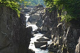
Tourism[edit]
-
 A panorama view of Jōdogahama in Miyako city.
 -
 A view of Tono Country Village.
 -
 TheTakuboku IshikawaMemorial Museum in Morioka.
 -

-
-

-
 Sansa Odori, one of famous for summer event in northern Honshu.


ThePokémonGeodudewas announced as the tourism ambassador to Iwate Prefecture.[18]The character was chosen for being a rock type Pokémon, since the word for rock, in Japanese, is Iwa ( nhamIwa).
Transportation[edit]
Rail[edit]
Iwate is served by theEast Japan Railway Company(JR East) which operates two high-speedshinkansenlines in the prefecture and seven local rail lines. TheTōhoku Shinkansenhas stations at Ichinoseki, Oshu, Kitakami, Hanamaki, Morioka, Iwate Town and Ninohe. TheAkita Shinkansenstarts at Morioka Station and connects to locations in Akita Prefecture.
JR East operates passenger and freight trains on theTōhoku Main Lineor Tōhoku-honsen in Iwate but sold the track north of Morioka to theIwate Galaxy Railway Linein 2002. The two lines share track with JR still running freight trains and some passenger trains over IGR track and IGR running occasional passenger trains as far south as Hanamaki. There is a large JR freight yard and maintenance facility in Yahaba.
Local lines include the Ofunato Line, the Kitakami Line, the Kamaishi Line, the Tazawako Line, the Yamada Line and the Hanawa Line.
Other lines include theSanriku Railwaywhich operates two lines along the coast, the North Rias Line and the South Rias Line.
Road[edit]

Expressways[edit]
 Tōhoku Expressway
 Hachinohe Expressway
 Akita Expressway
 Hachinohe-Kuji Expressway
- Sanriku Expressway
 Kamaishi Expressway
National highways[edit]
 National Route 4
 National Route 45
 National Route 46
 National Route 106
 National Route 107
 National Route 281
 National Route 282
 National Route 283
 National Route 284
 National Route 340
 National Route 342
 National Route 343
 National Route 346
 National Route 395
 National Route 396
 National Route 397
 National Route 455
 National Route 456
 National Route 457
Air[edit]
Sea[edit]
See also[edit]
Notes[edit]
- ^"2020 niên độ quốc dân kinh tế tính toán ( 2015 năm tiêu chuẩn cơ bản ・2008SNA ): Kinh tế xã hội tổng hợp viện nghiên cứu - Nội Các phủ".Nội Các phủ ホームページ(in Japanese).Retrieved18 May2023.
- ^Frédéric, "Tōhoku" inJapan Encyclopedia,p. 970, atGoogle Books
- ^Frédéric, "Morioka" inJapan Encyclopedia,p. 661, atGoogle Books
- ^"【 dân lời nói ・ tích lời nói 】 quỷ の tay hình".Bunka.pref.iwate.jp.Retrieved7 June2013.
- ^"Japanese Culture and Food: Iwate".Sapporo.co.uk.Archived fromthe originalon 27 March 2020.Retrieved27 March2020.
- ^"A Story of Delicious Apples".Japanold.16 December 2018.Retrieved27 March2020.
- ^"Ngôn い vân えられた bình tuyền".Iwate Prefectural Office. Archived fromthe originalon 13 October 2013.Retrieved7 June2013.
- ^Frédéric, "Provinces and prefectures" inJapan Encyclopedia,p. 780, atGoogle Books,p. 780.
- ^Tự nhiên công viên đều đạo phủ huyện đừng diện tích tổng quát[General overview of area figures for Natural Parks by prefecture](PDF)(in Japanese).Ministry of the Environment.31 March 2019.Retrieved17 August2019.
- ^Tự nhiên công viên の chủng loại[Types of Natural Parks] (in Japanese). Iwate Prefecture.Retrieved17 August2019.
- ^Schreiber, Mark, "Japan's food crisis goes beyond recent panic buying",The Japan Times,17 April 2011, p. 9.
- ^Kyodo News,"Sea Shepherd's return to Iwate town enrages local fishermen",The Japan Times,26 May 2011, p. 2.
- ^"Current Population Estimates as of October 1, 2019".1 October 2019.
- ^"Famous people of Iwate".
- ^"27. Iwatesan"(PDF).Japan Meteorological Agency.
- ^"38-meter-high tsunami triggered by March 11 quake: survey".Kyodo News. Archived fromthe originalon 6 April 2011.Retrieved7 June2013.
- ^Fukada, Takahiro (21 September 2011)."Iwate fisheries continue struggle to recover".The Japan Times.p. 3.
- ^Dennison, Kara."Iwate Prefecture Adopts Geodude as Its Official Pokémon".Crunchyroll(in Brazilian Portuguese). Archived fromthe originalon 7 April 2023.Retrieved31 May2019.
References[edit]
- Frédéric, Louis (2002 [1996]).Japan Encyclopedia.Translated by Käthe Roth. Cambridge, Massachusetts:Harvard University Press.ISBN0-674-01753-6,ISBN978-0-674-01753-5.OCLC58053128.
- Yiengpruksawan, Mimi Hall (1998).Hiraizumi: Buddhist Art and Regional Politics in Twelfth Century Japan.Cambridge, Massachusetts: Harvard University Press.ISBN0674392051,ISBN9780674392052.OCLC38738867.
External links[edit]
- Iwate Prefecture Official Website(in Japanese)
| Core city | ||
|---|---|---|
| Cities | ||
| Districts | ||

| Nuclear accidents |
| ||||||||
|---|---|---|---|---|---|---|---|---|---|
| Foreshocks, Aftershocks |
| ||||||||
| Relief and Recovery |
| ||||||||
| Pop culture | |||||||||
| Other | |||||||||
| International | |
|---|---|
| National | |
| Geographic | |
| Academics | |
| Other | |