
Jhelum River
| Jhelum | |
|---|---|
 Jhelum River photographed in Pakistan,c. 2006 | |
 Map showing the Jhelum's course[6] | |
| Location | |
| Countries | India,Pakistan |
| Physical characteristics | |
| Source | |
| • location | Verinag Spring |
| • coordinates | 33°32′05″N75°14′59″E/ 33.53472°N 75.24972°E |
| Mouth | |
• location | Chenab Riverat Trimmu,Jhang District |
• coordinates | 31°10′N72°09′E/ 31.17°N 72.15°E |
| Length | 725 km (450 mi) |
| Discharge | |
| • average | 1,026.6 m3/s (36,250 cu ft/s) (nearMangla Dam) |
| • minimum | 234.19 m3/s (8,270 cu ft/s) (nearMangla Dam) |
| • maximum | 26,419.13 m3/s (932,983 cu ft/s) (near Mangla Dam) |
| Discharge | |
| • average | 313.19 m3/s (11,060 cu ft/s) (nearDomel) |
| Discharge | |
| • average | 229.20 m3/s (8,094 cu ft/s) (nearBaramulla) |
| Basin features | |
| River system | Indus River |
| Tributaries | |
| • left | Poonch River,Sukhnag River |
| • right | Arpath River,Lidder River,Kishanganga River/Neelum River,Sind River,Kunhar River,Pohru River,Erin River |
TheJhelum River[a]is a river in the northernIndian subcontinent.It originates atVerinagand flows through the Indianunion territoryofJammu and Kashmir,into Pakistan-administeredAzad Kashmir,then the Pakistani province ofPunjab.It is the westernmost of thefive riversof thePunjab region,and flows through theKashmir Valley.It is atributaryof theChenab Riverand has a total length of about 725 kilometres (450 mi).[7]
Etymology[edit]

APakistaniauthor Anjum Sultan Shahbaz recorded some stories of the name Jhelum in his bookTareekh-e-Jhelumas:[8]
Many writers have different opinions about the name of Jhelum. One suggestion is that in ancient days Jhelumabad was known as Jalham. The word Jhelum is reportedly derived from the words Jal (pure water) and Ham (snow). The name thus refers to the waters of a river (flowing beside the city) which have their origins in the snow-cappedHimalayas.
TheSanskritname for the river isVitástā,derived from an apocryphal[citation needed]legend regarding the origin of the river in theNilamata Purana.The name survives in theKashmiriname for this river,Vyathand inPunjabi(and more commonly inSaraiki[9]) asVehat.[10]
History[edit]

The river Jhelum was originally recognized by the name Vitasta. The river was calledHydaspes(Greek:Ὑδάσπης) by theancient Greeks.
Alexander III of Macedonand his army crossed the Jhelum in BCE 326 at theBattle of the Hydaspes River,where he defeated an Indian king,Porus.According toArrian(Anabasis,29), he built a city "on the spot whence he started to cross the river Hydaspes", which he namedBukephala(orBucephala) to honour his famous horseBucephalus,buried in present-dayJalalpur Sharif.It is thought that ancient Bukephala was near the site of modernJhelum.[citation needed]According toGujrat districthistorian Mansoor Behzad Butt, Bukephalus was buried in Jalalpur Sharif, but the people ofMandi Bahauddin,a district close to Jehlum, believed that theirtehsilPhaliawas named after Alexander's dead horse, saying that the namePhaliawas a distortion ofBucephala.
The waters of the Jhelum are allocated toPakistanunder the terms of theIndus Waters Treaty.India is working on ahydropowerproject on a tributary of Jhelum river to establish first-use rights on the river water over Pakistan as per theIndus Waters Treaty.[11]
Legends[edit]

According to Hindupuranas,the goddessParvatiwas requested by the sageKashyapato come toKashmirto purify the land from the evil practices and impurities of thepishachasliving there. Parvati assumed the form of a river in thenetherworld.Her consortShivastruck with his spear near the abode of Nila, (Verinag spring). With this stroke of the spear, Parvati emerged from the netherworld. He excavated a ditch measuring onevitastiusing the spear,[12]through which the river, originating from the netherworld, came out, and so he gave her the nameVitástā.[13]
Theancient Greeksalso regarded the river as a god, as they did most mountains and streams. The poetNonnusin theDionysiaca[14]calls theHydaspesatitan-descended god, the son of the sea-godThaumasand the cloud-goddessElektra,the brother ofIris,goddess of therainbow,and half-brother to theharpies,the snatching winds. Since the river is in a foreign country, it is not clear whether they named the river after the god, or whether the godHydaspeswas named after the river.
Course[edit]
The river Jhelum rises from Verinag spring at the foot of thePir Panjalin the southeastern Kashmir Valley administered by India. It is joined by its tributaries
- Lidder Rivernear village Mirgund atKhanabal
- Veshaw Riverat Sangam inAnantnag
- Sind Riverat Shadipora
- Pohru RiveratDoabgahinSopore,Jammu and Kashmir.
It flows throughSrinagarandWular Lakebefore entering Pakistan-administered Kashmir through a deep narrow gorge. TheKishanganga River/Neelum River,the largest tributary of the Jhelum, joins it atDomel,Muzaffarabad,as does the next largest, theKunhar RiverofKaghan Valley.It is then joined by thePoonch River,and flows into theMangla Damreservoir in theMirpur District.The Jhelum entersPakistani Punjabin theJhelum District.From there, it flows through the plains of Pakistan's Punjab, forming the boundary between theJechandSindh Sagar Doabs.It ends in a confluence with theChenab RiveratTrimmuin theJhang District.The Chenab merges with theSutlejto form thePanjnad River,which joins theIndus RiveratMithankot.
Most of the villages and important cities of Kashmir valley are situated on the banks of Jhelum.[15]
Lakes[edit]
Dams, barrages and bridges[edit]
The river has rich power generation potential in India. Water control structures are being built as a result of theIndus Basin Project,including the following:
- Mangla Dam,completed in 1967, is one of the largestearth-filldams in the world, with a storage capacity of 5,900,000 acre-feet (7.3 km3)
- Karot Hydropower Projectis an under-construction[when?]concrete-core rockfill gravity large dam in Pakistan, with a planned installed capacity of 720 MW.
- Rasul Barrage,constructed in 1967, has a maximum flow of 850,000 ft³/s (24,000 m³/s).
- Trimmu Barrage,constructed in 1939 some 20 km from Jhang Sadar at the confluence with the Chenab, has maximum discharge capacity of 645,000 ft³/s (18,000 m³/s).
- Victoria Bridge,Haranpur,constructed in 1973, approximate 5 km fromMalakwalnearChak Nizamvillage. Its length is 1 km, mainly used byPakistan Railways,but there is a passage for light vehicles, motorcycles, cycles and pedestrians on one side.
- Uri Damwith 480 MW Hydroelectric station is located inBaramulladistrict of Jammu and Kashmir.[16]
- Uri Dam II with 240 MW Hydroelectric station is also located in Baramulla district of Jammu and Kashmir.[17]
- Kishanganga Hydroelectric Plantwith 330 MW Hydroelectric station is located inBandiporadistrict of Jammu and Kashmir.[18]
Canals[edit]
- Canals in and around the city ofSrinagar.
- TheUpper Jhelum Canalruns fromMangla Damto theChenab.
- TheRasul-Qadirabad Link Canal.
- TheChashma-Jhelum Link Canalruns from theChashma Barrageon theIndus Riverto the Jhelum river downstream ofRasul Barrage.This is 40 kilometres (25 mi) from Mari Shah Sakhira town.
Gallery[edit]
-
 Jhelum river, Baramullah, Kashmir, 1880s
 -
 Jhelum River c. 1900; photo taken by Eugene Whitehead Esq.
 -

-
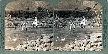 Rope BridgeatKarli,1908
 -
 Bridge over the river,Srinagar,1969
 -
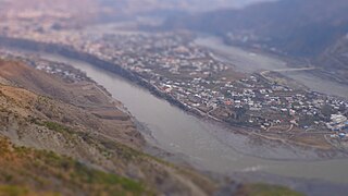
 Jhelum river nearMuzaffarabad(2014)
 -
 File:River Jehlum, Muzaffarabad
 -
 Near Muzaffarabad, 2014
 -
 The Jhelum atVerinag,2014
 -
 Jhelum River atJhelumCity, 2005


See also[edit]
Notes[edit]
- ^Urdu pronunciation:[dəɾˌjɑː.ed͡ʒeɦˈləm],Saraiki pronunciation:[veˈɦət̪dəɾˌjɑː];Punjabi pronunciation:[d͡ʒéˈlɐm/véːt̪ᵊnəˈd̪iː],Kashmiri pronunciation:[wʲatʰdərʲjaːw]
References[edit]
- ^The Quarterly Review.Murray. 1816. p. 170.Archivedfrom the original on 16 July 2023.Retrieved17 March2017.
- ^Bakshi, S. R. (1997).Kashmir Through Ages.Sarup & Sons. p. 110.ISBN9788185431710.Archivedfrom the original on 16 July 2023.Retrieved17 March2017.Five volumes.
- ^Rapson, E. J. (9 June 2011).Ancient India: From the Earliest Times to the First Century AD.Cambridge University Press. p. 171.ISBN9780521229371.Archivedfrom the original on 16 July 2023.Retrieved1 November2020.
- ^Naqvi, Saiyid Ali (November 2012).Indus Waters and Social Change: The Evolution and Transition of Agrarian Society in Pakistan.Oxford University Press Pakistan. p. 10.ISBN9780199063963.Archivedfrom the original on 16 July 2023.Retrieved17 March2017.
- ^Know Your State: Jammu and Kashmir.Arihant Publications (India) Ltd. November 2012. p. 35.ISBN9789313169161.Archivedfrom the original on 7 April 2022.Retrieved6 November2021.
- ^"Jhelum - uMap".
- ^"Jhelum River".Encyclopædia Britannica.Archived1 May 2015 at theWayback Machine.Retrieved on 4 October 2013.
- ^Shahbaz, Anjum Sultan (2003).Tārīkh-i Jihlam(in Urdu). Main Bazar, Jhelum: Buk Kārnar [Book Corner].OCLC60589679.
- ^"Punjab Portal".Retrieved12 June2024.
or Vehat, the latter name being more common towards the south of the district.
- ^Soofi, Mushtaq (20 November 2015)."Punjab Notes: Vehat: where great warriors clashed".DAWN.COM.Retrieved12 June2024.
- ^"India fast-tracks work on Jhelum river hydroelectric power project".Archivedfrom the original on 3 June 2010.Retrieved25 May2010.
- ^(a particular measure of length defined either as a long span between the extended thumb and little finger, or as the distance between the wrist and the tip of the fingers, and said to be about 9 inches
- ^Nilamata PuranaEnglish Translation by Dr.Ved Kumari Ghai,verses 247–261.
- ^section 26, line 350
- ^"District Survey Report On Kashmir"(PDF).District Survey Report.Archived(PDF)from the original on 14 February 2022.Retrieved13 February2022.
- ^"NHPC Limited: Projects: Power Stations: Uri – I".nhpcindia.Archivedfrom the original on 5 April 2022.Retrieved14 February2021.
- ^"NHPC Limited: Projects: Power Stations: Uri-II".nhpcindia.Archivedfrom the original on 30 October 2019.Retrieved14 February2021.
- ^"NHPC Limited: Projects: Power Stations: Kishanganga".nhpcindia.Retrieved14 February2021.
External links[edit]
- Livius.org pictures of the HydaspesArchived14 October 2013 at theWayback Machine
| Passes |  | |
|---|---|---|
| Valleys | ||
| Cities | ||
| Towns |
| |
| Rivers | ||
| Glaciers | ||
| Lakes | ||
| Mountains | ||
| Hill stations and Mughal gardens | ||
| Protected areas | ||
| See also | ||

| International | |
|---|---|
| National | |