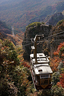
Kankakei Ropeway
Appearance
This articleneeds additional citations forverification.(October 2024) |
| Kankakei Ropeway | |
|---|---|
 | |
| Overview | |
| Status | Operational |
| Character | Aerial tramway |
| Location | Kankakei(a gorge onShōdoshimaIsland) inShōdoshima,Kagawa,Japan |
| No.of stations | 2 |
| Open | 1963[1] |
| Operation | |
| Carrier capacity | 40 Passengers per cabin, 2 cabins |
| Trip duration | 5 min |
| Technical features | |
| Line length | 917m(3,009ft) |
| No.of cables | 3 |
| Vertical Interval | 312 m (1,024 ft) |
TheKankakei Ropeway(Hàn hà 渓ロープウェイ,Kankakei Rōpuwei)is a Japaneseaerial liftline inShōdoshima,Kagawa.This is the only line operated byShōdoshima Sōgō Kaihatsu(Đậu đỏ đảo tổng hợp khai phát,"Shōdoshima General Development" ).The line opened in 1963. It runs throughKankakei,agorgeonShōdoshimaIsland. The gorge is known for its unique view, made bydiastrophismsanderosions.
Basic data
[edit]See also
[edit]References
[edit]- ^"Quan quang khách の an toàn が đệ nhất! Đậu đỏ đảo の hàn hà 渓でGWを trước にロープウエーで の ゴンドラ sự cố を tưởng định した cứu trợ huấn luyện 【 hương xuyên 】".Yahoo News (JP).OHK cương sơn truyền. April 26, 2024.Retrieved14 October2024.
External links
[edit]- (in Japanese)Official website
Wikimedia Commons has media related toKankakei Ropeway.
34°30′55.6″N134°18′2.1″E/ 34.515444°N 134.300583°E
