
Khoy
Khoy
Persian:خوی | |
|---|---|
City | |
 Khoy | |
| Coordinates:38°32′47″N44°57′15″E/ 38.54639°N 44.95417°E[1] | |
| Country | Iran |
| Province | West Azerbaijan |
| County | Khoy |
| District | Central |
| Government | |
| •Mayor | Hassan Nasrollah pour |
| •Parliament | Adel Najafzadeh |
| Elevation | 1,148 m (3,769 ft) |
| Population (2016)[3] | |
| • Total | 198,845 |
| Time zone | UTC+3:30(IRST) |
| Area code | 044-3 |
| Website | www |
Khoy(PersianandAzerbaijani:خوی)[a]is a city in theCentral DistrictofKhoy County,West Azerbaijanprovince,Iran,serving as capital of both the county and the district.[6]Occupied sinceMediantimes, it shares a long history as an importantChristiancenter.[7]
History
[edit]Khoy was named in ancient times for the salt mines that made it an important spur of the Silk Route.[7]3000 years ago, a city existed on the area where Khoy is located nowadays, but its name became Khoy only in the 14th centuries ago.[8]In 714 BC,Sargon IIpassed the region of which Khoy is part of in a campaign againstUrartu.[8]
During the reign ofGreater Armeniathis city was a part ofNor-Shirakanprovince (ashkar). Khoy was mentioned in the 8th century AD and was calledHerbyAnania Shirakatsiin "Ashkharatsuyts".
In theParthianperiod, Khoy was the gateway of the Parthian Empire in the Northwest. During the reign of Armenian kingTigranes the Great,Khoy is mentioned as being an important settlement of theSilk Route.[8]Around the year 37 BC,Mark Antonyhad crossed the plain that is located between Khoy andMarandduring one of the many and frequentRoman-Parthian Wars.[8]
Scholars such asJosef Markwartconsider Khoy to be the identical to theGobdistation mentioned in theTabula Peutingeriana.[9]
One of the important historic elements of the city isSurp Sarkis Church.Armeniandocuments wrote that the date of the making has to be either 332 or 333 AD.[8]In the city and its surrounding villages, churches are seen and it is reported thatArmenianshave always been comprising a significant amount of the city’s population.[8][page needed]
By the first half of the 11th century theByzantine emperorswere actively trying to round off their eastern territories, in an attempt to absorb the unstable Armenian dynasties. In 1021-2 emperorBasil IIled his army as far as Khoy within 175 km ofDvin,and obtained the surrender of royalty from theArtsruni dynastyofVan.[10]
In 1210, the city was conquered by the forces ofKingdom of Georgiasent byTamar the Greatunder the command of Zakaria and IvaneMkhargrdzeli.This was a response to the sacking of Georgian-controlledAniwhich occurred in 1208 and left 12,000 Christians dead.[11][12][13]
The city was ruled over by Malika, wife ofJalal al-Din Mangburniafter his conquest of the city in the late 1220s.[14]
Modern period
[edit]
In the wake of the demise of theSafavids,theOttomanstook Khoy on 6 May 1724, a territorial gain which was confirmed withImperial Russiathrough theTreaty of Constantinople (1724).[15]
Until 1828, Khoy had a large number ofArmenians;however, theTreaty of Turkmenchay(1828), gave the Russians the right to encourage Armenians to immigrate into the Russian Empire. Nevertheless, a small Armenian population remained living in Khoy. This was noted by an American missionary in 1834.[16]He noted further that in the villages around Khoy there were a few more, but the vast majority had migrated to the North of theAras riverfollowing Russia's victory over Persia in 1828 and the encouraged settling in the newly incorporated Russian regions ofEastern Armenia.[16]
With the advent of the 1910s, Khoy was occupied byOttomantroops, but they were completely expelled from the area by the Russians by 1911.[17]Khoy was one of the many cities in Iran which garrisoned Russian infantry andCossacks.[17]The Russians retreated at the time ofEnver Pasha's offensive in the Iran-Caucasus region, but returned in around early 1916, and stayed in the region up to the wake of theRussian Revolution.[17]In 1918, for a final brief period, theOttomanstook Khoy until the decisive end ofWorld War Iand theArmistice of Mudros.[17]InWorld War II,Khoy was again occupied bySoviettroops, who remained until1946.After 1946 the city indefinitely became part ofIranand is located in the far northwest of the country.
Demographics
[edit]Population
[edit]At the time of the 2006 National Census, the city's population was 178,708 in 45,090 households.[18]The following census in 2011 counted 200,958 people in 57,149 households.[19]The 2016 census measured the population of the city as 198,845 people in 59,964 households.[3]
Geography
[edit]Location
[edit]Khoy is north of the province's capital and largest cityUrmia,and 807 km north-west toTehran.The region's economy is based onagriculture,particularly the production of fruit, grain, and timber. Khoy is nicknamed as theSunflowercity of Iran. At the 2006 census, the city had a population of 178,708, with an estimated 2012 population of 200,985. Khoy is largely populated by ethnicAzerbaijanis,[20]except for the residents of the western edge of Khoy, who are mostlyKurds;The majority of the population (more than 90%) subscribes to theShiitesect of Islam. TheKurdsof this less, who live mostly in a nomadic way as opposed to the mostly settledAzerbaijanis,are largelySunniand are composed of two independent tribes,Shakkakand Madrumi.[21]
Climate
[edit]Köppen-Geiger climate classification systemclassifies its climate ascold semi-arid(BSk).[22]
Highest recorded temperature:42.8 °C (109.0 °F) on 26 July 2020[23]
Lowest recorded temperature:−30.0 °C (−22.0 °F) on 24 January 1964[24]
| Climate data for Khoy (1991-2020, extremes 1959-present)[i] | |||||||||||||
|---|---|---|---|---|---|---|---|---|---|---|---|---|---|
| Month | Jan | Feb | Mar | Apr | May | Jun | Jul | Aug | Sep | Oct | Nov | Dec | Year |
| Record high °C (°F) | 17.0 (62.6) |
20.2 (68.4) |
27.2 (81.0) |
32.0 (89.6) |
35.6 (96.1) |
39.8 (103.6) |
42.8 (109.0) |
41.6 (106.9) |
40.0 (104.0) |
32.6 (90.7) |
25.0 (77.0) |
21.4 (70.5) |
42.8 (109.0) |
| Mean daily maximum °C (°F) | 3.4 (38.1) |
7.1 (44.8) |
13.4 (56.1) |
19.2 (66.6) |
24.1 (75.4) |
29.8 (85.6) |
33.1 (91.6) |
33.3 (91.9) |
28.9 (84.0) |
21.7 (71.1) |
12.8 (55.0) |
5.6 (42.1) |
19.4 (66.9) |
| Daily mean °C (°F) | −1.5 (29.3) |
1.5 (34.7) |
7.3 (45.1) |
12.9 (55.2) |
17.5 (63.5) |
22.6 (72.7) |
25.8 (78.4) |
25.5 (77.9) |
20.8 (69.4) |
14.3 (57.7) |
6.6 (43.9) |
0.6 (33.1) |
12.8 (55.1) |
| Mean daily minimum °C (°F) | −6.0 (21.2) |
−3.7 (25.3) |
1.2 (34.2) |
6.3 (43.3) |
10.6 (51.1) |
14.6 (58.3) |
17.8 (64.0) |
17.3 (63.1) |
12.4 (54.3) |
7.2 (45.0) |
1.3 (34.3) |
−3.4 (25.9) |
6.3 (43.3) |
| Record low °C (°F) | −30.0 (−22.0) |
−27.0 (−16.6) |
−20.6 (−5.1) |
−8.0 (17.6) |
−0.2 (31.6) |
3.4 (38.1) |
8.0 (46.4) |
7.0 (44.6) |
2.0 (35.6) |
−7.0 (19.4) |
−15.7 (3.7) |
−25.4 (−13.7) |
−30.0 (−22.0) |
| Averageprecipitationmm (inches) | 15.0 (0.59) |
16.6 (0.65) |
29.4 (1.16) |
46.1 (1.81) |
47.1 (1.85) |
23.8 (0.94) |
9.7 (0.38) |
6.0 (0.24) |
10.1 (0.40) |
19.7 (0.78) |
25.6 (1.01) |
18.7 (0.74) |
267.8 (10.55) |
| Average precipitation days(≥ 1.0 mm) | 3.4 | 3.8 | 5.2 | 7.5 | 8.5 | 4.2 | 1.8 | 1.3 | 1.8 | 3.4 | 4.1 | 4.4 | 49.4 |
| Average rainy days | 2.1 | 3.1 | 7.3 | 11.6 | 10.4 | 4.8 | 2.2 | 2 | 2.6 | 5.7 | 5.7 | 3.9 | 61.4 |
| Average snowy days | 5 | 5.1 | 2.9 | 0.3 | 0 | 0 | 0 | 0 | 0 | 0.1 | 1.7 | 4 | 19.1 |
| Averagerelative humidity(%) | 74 | 66 | 56 | 55 | 55 | 47 | 45 | 44 | 48 | 58 | 68 | 76 | 58 |
| Averagedew point°C (°F) | −6.0 (21.2) |
−5.0 (23.0) |
−2.0 (28.4) |
2.7 (36.9) |
7.1 (44.8) |
9.4 (48.9) |
11.9 (53.4) |
11.2 (52.2) |
8.0 (46.4) |
5.0 (41.0) |
0.5 (32.9) |
−3.6 (25.5) |
3.3 (37.9) |
| Mean monthlysunshine hours | 117 | 146 | 183 | 204 | 254 | 317 | 344 | 335 | 289 | 224 | 167 | 113 | 2,693 |
| Source 1:NCEI[25](snow and sleet days 1981-2010)[26] | |||||||||||||
| Source 2:IRIMO(extremes 1959-2010)[27][24]Meteomanz(since 2021)[28] | |||||||||||||
- ^Rainy days calculated using parameters 46 and 71 from the first source. (days with rain showers and days with rain/drizzle)
Sights
[edit]Khoy is well known for thetomb of Shams Tabrizi,renowned Iranian poet and mystic.


-

-
 city center square
 -
 Khoy bazaar
 -
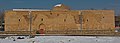
 historical Kabiri House in Khoy
 -
 Khoy Airport
 -
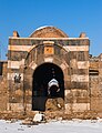 Stone gate of Khoy
 -
 Kabiri House
 -
 Kabiri House
 -
 Kabiri House
 -
-

-
 Mahlezan church
 -
-
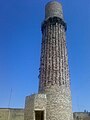
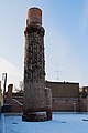 Tomb of Shams Tabrizi
 -
 Tomb of Shams Tabrizi
 -
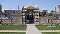 Stone gate of Khoy


Famous places
[edit]- Tomb ofShams Tabrizi,Shams Tabrizi Tower
- Bastam and Bolourabad Castles
- Khatoon Bridge
- Old Stone Gate
- Old Bazaar
- Motallebkhan Mosque
- Mount Avrin
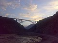
- Ghotour Iron Bridge[29]
- Surp Sarkis Church
- Pourya-ye Vali
Notable natives
[edit]For a complete list see:Category:People from Khoy
-
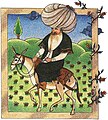 Mullah Nasreddin,satirical Sufi.
 -
 Jahan Shah,was the leader of the Kara Koyunlu oghuz Turks tribal federation in Azerbaijan and Arran.
 -
 Jaleh Amouzgar,is anIranologistand a university professor.
 -
 Behrouz Vossoughi,is an Iranian actor.


Twin towns
[edit]See also
[edit]- Donboli(tribe)
- Khoy Khanate
- Nor Shirakan
- Zaravand
![]() Media related toKhoyat Wikimedia Commons
Media related toKhoyat Wikimedia Commons
Notes
[edit]References
[edit]- ^OpenStreetMap contributors (16 February 2024)."City, Khoy County"(Map).OpenStreetMap(in Persian).Retrieved16 February2024.
- ^"Xoy, Iran Page".Archived fromthe originalon 7 March 2008.Retrieved7 July2008.
- ^ab"Census of the Islamic Republic of Iran, 1395 (2016)".AMAR(in Persian). The Statistical Center of Iran. p. 04. Archived fromthe original(Excel)on 30 August 2022.Retrieved19 December2022.
- ^Khoy can be found atGEOnet Names Server,atthis link,by opening the Advanced Search box, entering "-3071618" in the "Unique Feature Id" form, and clicking on "Search Database".
- ^"چوار کۆڵبەر لە سنورەکانی بانە و خۆی کوژران و برینداربون"(in Kurdish). 9 May 2020.Retrieved1 August2020.
- ^Habibi, Hassan (7 July 1369)."Approval of the organization and chain of citizenship of the elements and units of the country divisions of West Azerbaijan province, centered in the city of Urmia".Lamtakam(in Persian). Ministry of Interior, Council of Ministers. Archived fromthe originalon 20 December 2023.Retrieved20 December2023.
- ^abAndrew Burke, "Iran" pp. 138. Lonely Planet.ISBN1742203493
- ^abcdefLida Balilan Asl, Elham Jafari. "Khoy's Expansion from Early Islam to Late Qajar According to Historical Documents" published spring 2013. vol 3
- ^Manandian 1965,p. 113.
- ^Minorsky, Vladimir(1953).Studies in Caucasian History: I. New Light on the Shaddadids of Ganja II. The Shaddadids of Ani III. Prehistory of Saladin.CUP Archive. p. 52.ISBN978-0-521-05735-6.
- ^L. Baker, Patricia; Smith, Hilary; Oleynik, Maria (2014).Iran.London, United Kingdom: Bradt Travel Guides. p. 158.ISBN978-1841624020.
- ^Salia, Kalistrat (1983).History of the Georgian nation.Madison, WI: University of Wisconsin. p. 181.
- ^Mikaberidze, Alexander (2011).Conflict and Conquest in the Islamic World: A Historical Encyclopedia, Volume 1.Santa Barbara, California, USA: ABC-CLIO. p. 196.ISBN978-1598843361.
- ^Tamta's World by Anthony Eastmond, page 108
- ^Somel, Selcuk Aksin (2003).Historical Dictionary of the Ottoman Empire.Scarecrow Press. p. xlvi.ISBN978-0810866065.
- ^abSmith noted that the city had between 4000 and 7000 Muslim families, while only about 100 Armenian families were left.Smith, Eli(1834).Missionary Researches in Armenia: Including a Journey through Asia Minor, and into Georgia and Persia.G. Wightmann. p. 315.
- ^abcdAtabaki 2006,p. 70.
- ^"Census of the Islamic Republic of Iran, 1385 (2006)".AMAR(in Persian). The Statistical Center of Iran. p. 04. Archived fromthe original(Excel)on 20 September 2011.Retrieved25 September2022.
- ^"Census of the Islamic Republic of Iran, 1390 (2011)".Syracuse University(in Persian). The Statistical Center of Iran. p. 04. Archived fromthe original(Excel)on 20 January 2023.Retrieved19 December2022.
- ^encyclopaedia islamica:اهالی شهرستان خوی به زبان ترکی سخن میگویند (صدراییخویی، 1373ش، ص 65)
- ^Encyclopedia of Islamic World:به جز ساکنان حاشیه غربی شهرستان خوی که بیشتر کرد هستند؛ اکثریت جمعیت منطقه (بیش از ۹۰٪) شیعه دوازده امامیاند. کردهای این منطقه بیشتر به صورت عشایری زندگی میکنند و از دو طایفه مستقل کرهسنی و مدرومی هستند
- ^"Climate: Khoy - Climate graph, Temperature graph, Climate table".Climate-Data.org.Retrieved9 September2013.
- ^"KHOY - Month summary: July 2020".meteomanz.Retrieved4 July2024.
- ^ab"Form 6: TEMPERATURE RECORDS LOWEST IN C. Station: Khoy(40703)".Chaharmahalmet(asp). Iran Meteorological Organization. Archived from the original on 19 August 2014.Retrieved4 July2024.
{{cite web}}:CS1 maint: unfit URL (link) - ^"World Meteorological Organization Climate Normals for 1991-2020: Khoy"(CSV).ncei.noaa.gov.National Oceanic and Atmosoheric Administration.Retrieved24 April2024.
WMO number: 40703
- ^"World Meteorological Organization Climate Normals for 1981-2010: Khoy"(XLS).ncei.noaa.gov.National Oceanic and Atmosoheric Administration.p. 26.Retrieved24 April2024.
WMO number: 40703
- ^"Form 7: TEMPERATURE RECORDS HIGHEST IN C. Station: Khoy(40703)".Chaharmahalmet(asp). Iran Meteorological Organization. Archived from the original on 19 August 2014.Retrieved4 July2024.
{{cite web}}:CS1 maint: unfit URL (link) - ^"KHOY - Weather data by months".meteomanz.Retrieved4 July2024.
- ^ "Ghotour Valley Bridge".American Bridge Company. Archived fromthe originalon 23 February 2013.Retrieved25 March2013.
- ^"Rumi Remembered in Birthplace of Shams".Archived fromthe originalon 7 April 2015.Retrieved21 March2015.
Sources
[edit]- Atabaki, Touraj(2006).Iran and the First World War: Battleground of the Great Powers.I.B.Tauris.ISBN978-1860649646.
- Gledhill, Kevin (2022)."Khoy (Ḵoy)".InYarshater, Ehsan(ed.).Encyclopædia Iranica, Online Edition.Encyclopædia Iranica Foundation.
- Manandian, Hakop(1965).Garsoïan, Nina(ed.).The Trade and Cities of Armenia in Relation to Ancient World Trade.Livraria Bertrand.(registration required)
External links
[edit]- The first portal fun of recreational and cultural city of KhoyArchived3 June 2013 at theWayback Machine
- Official website of Khoyee people's assembly
- Khoy government
- Khoy Municipality
- Nima Language Center
- Khoy journal
| International | |
|---|---|
| National | |
| Geographic | |
| Capital |  | |
|---|---|---|
| Counties andcities | ||
| Tourism | ||
| Places | ||