
Kiliia
Kiliia
Кілія(Ukrainian) | |
|---|---|
 Old street with the view at the St. Nicholas Church | |
 Coat of arms | |
 Kiliia Location in Ukraine  Kiliia Kiliia (Ukraine) | |
| Coordinates:45°27′N29°14′E/ 45.450°N 29.233°E | |
| Country | |
| Oblast | Odesa Oblast |
| Raion | Izmail Raion |
| Hromada | Kiliia urban hromada |
| City founded | 862 |
| Government | |
| • Mayor | Pavlo Boychenko |
| Area | |
| • Total | 19.5 km2(7.5 sq mi) |
| Elevation | 5 m (16 ft) |
| Population (2022) | |
| • Total | 18,745 |
| • Density | 960/km2(2,500/sq mi) |
| Time zone | UTC+2(EET) |
| • Summer (DST) | UTC+3(EEST) |
| Postal code | 68300 - 68303 |
| Area code | +380 4843 |
KiliiaorKilia(Ukrainian:Кілія,IPA:[ki.lʲiˈjɑ];Russian:Килия;Romanian:Chilia Nouă) is a city inIzmail Raion,Odesa Oblast,southwesternUkraine.It hosts the administration ofKiliia urban hromada,one of thehromadasof Ukraine.[1]Kiliia is located in theDanube Delta,in the historicBessarabiandistrict ofBudjak;across the river lies the town ofChilia Veche(Old Kiliia) in Romania. TheChilia branchof theDanuberiver, which separates Ukraine from Romania, is named after it. Population:18,745 (2022 estimate).[2]
History
[edit]
Byzantine Empireuntil 1361
From 1361 until 1412 contested betweenKingdom of Hungary,Wallachia,Polandand theOttoman Empire
Principality of Moldavia1412–1448
Kingdom of Hungary1448–1465
Ottoman Empire1484–1812
Russian Empire1812–1856
Moldavian Democratic Republic1917–1918
Kingdom of Romania1918–1940
Soviet Union1940–1941
Soviet Union1944–1991
Ukraine1991–present
A town on the Romanian side of the Chilia branch of the Danube, now known asChilia Veche(Ukrainian:Cтapa Кілія,translit.Stara Kiliia) or "Old Chilia", was founded by theGreek Byzantines– κελλία,kelliainGreekbeing the equivalent of "granaries", a name first recorded in 1241, in the works of thePersianchroniclerRashid-al-Din Hamadani.Kiliia is therefore sometimes referred to asNova Kiliiameaning "New Kiliia".
In the place that is now Kiliia, a large colony was established by theRepublic of Genoa,known as "Licostomo" and headed by a consul (a representative of the Republic in the region). From that time, only the defensive ditches of a Genoese fortress remained.[3]
The city was founded byStephen the GreatofMoldavia,in order to counteract theOttoman Empirewhich had taken control overChilia Vechein the 15th century. It was a majorMoldavianport. However,it was eventually conquered by the Ottomans in 1484.In 1570 (Hijri977) the town of Kilia was inhabited by Muslims and Christians. It had 298 Muslim households in 13 neighbourhoods and 316 Christian households in 5 neighbourhoods and it was a "has" of theSultan,a land property that was directly owned by the Sultan. One of the Muslim neighbourhoods was recorded as aCircassianneighbourhood.[4]Kiliia was taken by theRussianarmy under the command of the generalIvan GudovichduringRusso-Turkish War (1787–1792).TheTimesof London reported that "35,000 of the inhabitants were involved in a general massacre," an incident that had "been celebrated in prose and poetry." [5]The city was given back to the Ottomans in 1792, but retaken by the Russians in 1806 and awarded to them officially in 1812.

After being bombarded by the Anglo-French fleet in July 1854 during theCrimean War,it was given to Romania in theTreaty of Paris (1856).In 1878 (Congress of Berlin), Kiliia was transferred back to Russia together withBudjak.Between 1918 and 1940 (Interwar period,Greater Romania) it was again part of Romania. In July 1940, after a Soviet ultimatum, Romania agreed to give upBessarabiaandnorthern Bukovina;the Soviet Unionoccupied itand came to theUkrainian SSR(it washeld yet again by Romania,from 1941 to 1944, inWorld War II,time during which it was the capital of theChilia County), and passed on to independentUkraineafter thedissolution of the Soviet Union.
The oldest building in Kiliia is the semi-subterranean church of St. Nicholas, which may go back to 1485, although an old inscription in the church claims that it was founded on 10 May 1647.
Until 18 July 2020, Kiliia was the administrative center ofKiliia Raion.The raion was abolished in July 2020 as part of the administrative reform of Ukraine, which reduced the number ofraionsof Odesa Oblast to seven. The area of Kiliia Raion was merged into Izmail Raion.[6][7]
Demographics
[edit]As of the2001 Ukrainian census,Ukrainiansconstitue the majority of the town's population.Russians,MoldovansandBulgariansform significant minorities.[8]
In 2001, 55.5% of the inhabitants spoke Russian as their native language, while 39.56% spoke Ukrainian and 2.93% of the inhabitants spoke Romanian.[9]
Notable people
[edit]- Vadym Prystaiko(born 1970), Ukrainian diplomat
- Oleksandr Dubovoy(born 1976), Ukrainian politician (Batkivshchyna)
- Ihor Nesterenko(born 1990), Israeli-Ukrainian basketball player in theIsrael Basketball Premier League
Gallery
[edit]-
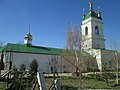
 Intercession of the Theotokos Church
 -
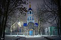
 St. Nicholas Church
 -
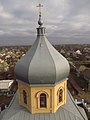 Skyline of Kiliia from one of the churches
 -
 Tombstone inKhersonof soldier fallen in the siege of Kiliia
 -
 Kiliia Fortress


References
[edit]- ^"Килийская громада"(in Russian). Портал об'єднаних громад України.
- ^Чисельність наявного населення України на 1 січня 2022[Number of Present Population of Ukraine, as of January 1, 2022](PDF)(in Ukrainian and English). Kyiv:State Statistics Service of Ukraine.Archived(PDF)from the original on 4 July 2022.
- ^"Генуэзские колонии в Одесской области - Бизнес-портал Измаила".2018-02-05. Archived fromthe originalon 2018-02-05.Retrieved2020-11-16.
- ^GÖKBİLGİN, M. TAYYİB (1956)."KANUNÎ SULTAN SÜLEYMAN DEVRİ BAŞLARINDA RUMELİ EYALETİ, LİVALARI, ŞEHİR VE KASABALARI".Belleten.20(78): 247–294.eISSN2791-6472.ISSN0041-4255.
- ^"The Seat of War on the Danube,"The Times,December 29, page 8
- ^"Про утворення та ліквідацію районів. Постанова Верховної Ради України № 807-ІХ".Голос України(in Ukrainian). 2020-07-18.Retrieved2020-10-03.
- ^"Нові райони: карти + склад"(in Ukrainian). Міністерство розвитку громад та територій України.
- ^"Національний склад міст".
- ^"Рідні мови в об'єднаних територіальних громадах України".
| Countries |  | |
|---|---|---|
| Cities | ||
| Tributaries | ||
| Canals | ||
| See also | ||
| International | |
|---|---|
| National | |
| Other | |
- Castles in Ukraine
- Castles in Moldavia
- Territories of the Republic of Genoa
- Populated places on the Danube
- Romania–Ukraine border crossings
- Port cities and towns in Ukraine
- Port cities of the Black Sea
- Cities of district significance in Ukraine
- Ismail County
- Chilia County
- Izmailsky Uyezd
- Cities in Izmail Raion
- Populated places in Kiliia urban hromada
- Kiliia