
Bay of Kotor
Bay of Kotor
Boka kotorska Бока которска | |
|---|---|
 View over Bay of Kotor | |
 Budva Municipality,historically considered a part of the Bay of Kotor region. | |
| Country | |
| Historical region | |
| Municipalities | Kotor,Herceg Novi,Tivat |
| Area | |
| • Total | 616 km2(238 sq mi) |
| Population | |
| • Total | 67,496 |
| Demonym(s) | Bokelj (masculine) Bokeljka (feminine) |
| Official name | Natural and Culturo-Historical Region of Kotor |
| Criteria | Cultural: i, ii, iii, iv |
| Reference | 125 |
| Inscription | 1979 (3rdSession) |
| Area | 14,600 ha |
| Buffer zone | 36,491 ha |
TheBay of Kotor(Croatian,MontenegrinandSerbian:Boka kotorska/Бока которска,Italian:Bocche di Cattaro), also known as theBoka,[1]is a winding bay of theAdriatic Seain southwesternMontenegroand the region of Montenegro concentrated around the bay. It is also the southernmost part of thehistorical regionofDalmatia.At the entrance to the Bay there isPrevlaka,a smallpeninsulain southernCroatia.The bay has been inhabited since antiquity. Its well-preserved medieval towns ofKotor,Risan,Tivat,Perast,PrčanjandHerceg Novi,along with their natural surroundings, are major tourist attractions. TheNatural and Culturo-Historical Region of Kotorwas designated a UNESCOWorld Heritage Sitein 1979. Its numerousOrthodoxandCatholicchurches and monasteries attract numerous religious pilgrims and other visitors.
Geography
[edit]


The bay is about 28 kilometres (17 mi) long with a shoreline extending 107.3 kilometres (66.7 mi). It is surrounded by twomassifsof theDinaric Alps:theOrjenmountains to the west, and theLovćenmountains to the east. The narrowest section of the bay, the 2,300-metre (7,500 ft) long Verige Strait, is only 340 metres (1,120 ft) wide at its narrowest point.[2]The bay is ariaof the vanished Bokelj River, which used to flow from the high mountain plateaus ofMount Orjen.
The bay is composed of several smaller broad bays, united by narrower channels. The bay inlet was formerly a river system. Tectonic andkarstificationprocesses led to the disintegration of this river. After heavy rains, the waterfall of Sopot spring atRisanappears, and Škurda, another well-known spring, runs through a canyon from Lovćen.
The outermost part of the bay is the Bay ofTivat.On the seaward side is the Bay ofHerceg Novi,at the main entrance to the Bay of Kotor. The inner bays are the Bay ofRisanto the northwest and the Bay ofKotorto the southeast.
The Verige Strait represents the bay's narrowest section and is located between Cape St. Nedjelja and Cape Opatovo; it separates the inner bay east of the strait from the Bay of Tivat.
Climate
[edit]The bay lies within theMediterraneanand northwards thehumid subtropical climatezone, but its peculiar topography and high mountains make it one of the wettest places in Europe, with Europe's wettest inhabited areas (although certainIcelandic glaciersare wetter[3]). The littoral Dinaric Alps and theAccursed Mountainsreceive the most precipitation, leading to small glaciers surviving well above the 0 °C (32 °F) mean annualisotherm.November thunderstorms sometimes drop large amounts of water. By contrast, in August the area is frequently completely dry, leading toforest fires.With a maximum discharge of 200 m3/s (7,100 cu ft/s), one of the biggestkarstsprings,the Sopot spring, reflects this seasonal variation. Most of the time it is inactive but after heavy rain a waterfall appears 20 metres (66 ft) above the Bay of Kotor.
| Station | Height [m] | Type | Character | Precipitation [mm] | Snow |
|---|---|---|---|---|---|
| Veliki kabao | 1894 | D | perhumid Mediterranean snowclimate | c.6250 | ap. 140 days |
| Crkvice | 940 | Cfsb | (fs= without summerdryness), perhumid Mediterranean mountain climate | 4926 | 70 days |
| Risan | 0 | Cs’’a | (s’’= double winter rain season), perhumid Mediterranean coast climate | 3500 | 0.4 days |
*classification scheme afterKöppen
Twowind systemshaveecologicalsignificance:BoraandJugo.Strong colddownslope windsof the Bora type appear in winter and are most severe in the Bay of Risan. Gusts reach 250 km/h (160 mph) and can lead to a significant temperature decline over several hours with freezing events. Boraweathersituations are frequent and sailors study the mountains as cap clouds indicate an imminent Bora event. Jugo is a warm humid wind and brings heavy rain. It appears throughout the year but is usually concentrated in autumn and spring.
Monthly and yearlyprecipitationranges:
| Station | Period | Height [m] | I | II | III | IV | V | VI | VII | VIII | IX | X | XI | XII | I-XII [mm/m²a] |
|---|---|---|---|---|---|---|---|---|---|---|---|---|---|---|---|
| Herceg Novi | 1961–1984 | 40 | 230 | 221 | 183 | 135 | 130 | 73 | 28 | 45 | 160 | 181 | 326 | 262 | 1974 |
| Risan | 1961–1984 | 40 | 405 | 342 | 340 | 235 | 153 | 101 | 66 | 123 | 188 | 295 | 423 | 434 | 3105 |
| Grahovo | 1961–1984 | 710 | 351 | 324 | 305 | 251 | 142 | 94 | 55 | 103 | 202 | 416 | 508 | 473 | 3224 |
| Podvrsnik | 1961–1984 | 630 | 407 | 398 | 367 | 305 | 151 | 101 | 77 | 132 | 238 | 465 | 593 | 586 | 3820 |
| Vrbanj | 1961–1984 | 1010 | 472 | 390 | 388 | 321 | 181 | 104 | 70 | 122 | 224 | 369 | 565 | 536 | 3742 |
| Knežlaz | 1961–1984 | 620 | 547 | 472 | 473 | 373 | 207 | 120 | 72 | 136 | 268 | 400 | 629 | 661 | 4358 |
| Crkvice | 1961–1984 | 940 | 610 | 499 | 503 | 398 | 198 | 135 | 82 | 155 | 295 | 502 | 714 | 683 | 4774 |
| Ivanova Korita | 1960–1984 | 1350 | 434 | 460 | 742 | 472 | 128 | 198 | 74 | 46 | 94 | 300 | 694 | 972 | 4614 |
| Goli vrh | 1893–1913 | 1311 | 271 | 286 | 307 | 226 | 188 | 148 | 75 | 70 | 215 | 473 | 415 | 327 | 3129 |
| Jankov vrh | 1890–1909 | 1017 | 424 | 386 | 389 | 346 | 212 | 124 | 55 | 58 | 202 | 484 | 579 | 501 | 3750 |
Hydrology
[edit]- Hydrologic system: karst hydrology ca. 4000 km2,Sopot, Škurda, submerged sources[clarification needed]
- Water area: 87 km2
- Max depth: 60 m
- Average depth: 27.3 m
- Water content:24,12306 km3(ca. 2.4 mrd m3)
- Highest point:Orjen(1894 m)
- Lowest point: sea surface (0 m)
- Length: 28,13 km
- Widest point: 7 km
- Narrowest point: || 0.3 km
History
[edit]Middle Ages
[edit]

TheSklavenoi,South Slavs,settled in the Balkans in the 6th century.[4][5]TheSerbs,mentioned in theRoyal Frankish Annalsof the mid-9th century, controlled a great part ofDalmatia( "Sorabos, quae natio magnam Dalmatiae partem obtinere dicitur").[6][7]Constantine VII PorphyrogennetosinDe Administrando Imperiomentions that, fromCroatswho came to Dalmatia, one part was separated and took rule inIllyricum.[8]The Slavic, Serbian tribes, consolidated under theVlastimirović dynasty(610–960).[citation needed]The two principalities ofDocleaandTravuniawere roughly adjacent at Boka. As elsewhere in theBalkans,Slavsmixed with theRomanpopulation of theseByzantinecoastal cities. TheTheme of Dalmatiawas established in the 870s. According toDe Administrando Imperio(ca. 960),Risanwas part of Travunia, a Serbian principality ruled by theBelojević family.[citation needed]
After theGreat Schismof 1054, the coastal region was under both Churches. In 1171,Stefan Nemanjasided with theRepublic of Venicein a dispute with the Byzantine Empire. The Venetians incited the Slavs of the easternAdriaticlittoralto rebel against Byzantine rule and Nemanja joined them, launching an offensive towardsKotor.The Bay was thenceforth under the rule of theNemanjić dynasty.In 1195, Nemanja and his sonVukanconstructed the Church of Saint Luka in Kotor. In 1219,Saint Savafounded the seat of theEparchy of ZetaonPrevlaka,[9]one of the eparchies of theSerbian Orthodox Church.Due to its protected location, Kotor became a major city for the salt trade. The area flourished during the 14th century under the rule ofEmperor of the SerbsDušan the Mightywho, notorious for his aggressive law enforcement, made the Bay of Kotor a particularly safe place for doing business.[10]
The city of Kotor was under Nemanjić rule until 1371. It was followed by a period of frequent political changes in the region. Local lords from theVojinovićandBalšićnoble families fought over the influence in the region. Since 1377, northern parts of the Bay region came under the rule ofTvrtko I Kotromanić,who proclaimed himselfKing of the Serbs and Bosnia.For several years (1385–1391), the city of Kotor also recognized the suzerainty of theKingdom of Bosnia.After 1391, it gained political independence, and functioned as a city-state until 1420. Its merchant fleet and importance gradually increased, but so was the interest of the powerful Republic of Venice for the city and the bay region. From 1405 to 1412, theFirst Scutari Warwas fought in the region.
Venetian rule (1420–1797)
[edit]In 1420, the city of Kotor recognized the Venetian rule,[11]marking the beginning of an era that would last until 1797. Northern parts of the Bay region still remained under the Kingdom of Bosnia, while southern parts were controlled theLordship of Zeta,followed by theSerbian Despotate.In the meanwhile, theSecond Scutari Warwas fought in the region, resulting in the peace treaties of 1423 and 1426.[citation needed]
By the middle of the 15th century, northern parts of the Bay region became incorporated into theDuchy of Saint Sava.In 1482,Ottomanstook the city ofNovi,establishing their rule in the northern parts of the Bay area. Under Ottoman rule, those regions were attached to theSanjak of Herzegovina.The Ottoman possessions in the Bay region were retaken at the end of the 17th century and the whole area became part of the Venetian Republic, within the province ofVenetian Albania.Until the 20th century, the difference between the two parts was visible because the former Ottoman part had anOrthodoxmajority, while the part that was under Venetian rule had aCatholicmajority.[12]
The town ofPerasthad difficult moments in 1654 when the Ottomans attacked, retaliating against Bokeljs who had sunk an Ottoman ship. The Bokeljs' successful defence of Perast and the Bay received attention all overEurope.It attractedPetar Zrinski,a statesman in Europe who had fought dramatic battles with the Turks. During his three-day sojourn in Perast he presented his legendary sword to the town in recognition for their efforts to defend their homeland, and to stop the Ottoman Empire.[citation needed]
In 1669, according toAndrija Zmajević,hajduksof the Bay[13]wished to build a church, but were denied due to Zmajević's intervention on theprovidurof Kotor and the captain of Perast.[14]Ottoman travel writerEvliya Çelebivisited the Bay of Kotor and mentioned Croats who lived in Herceg Novi.[15]
Modern history
[edit]

By theTreaty of Campo Formio(1797), the Bay region came under theHabsburgrule. By theTreaty of Pressburg(1805), the region was set to be transferred to theFrenchrule, but that was effectively achieved only after theTreaties of Tilsit(1807). Under the French rule, the Bay region was included in theNapoleonic Kingdom of Italyand later in theIllyrian Provinces,[16]which were a part of the French Empire. The region was later conquered byMontenegrowithRussianhelp byPrince-BishopPetar I Petrović-Njegošand, in 1813, a union of the bay area with Montenegro was declared. In 1815, the bay was annexed by theAustrian Empireand was included in the province ofDalmatia(part ofCisleithaniasince 1867). In 1848, when thenumerous revolutions sparked in the Austrian Empire,an Assembly of the Bay of Kotor was held sponsored byPetar II Petrović-Njegošof Montenegro, to decide on the proposition of the Bay's unification withBan of CroatiaJosip Jelačićin anattempt to uniteDalmatia,CroatiaandSlavoniaunder the Habsburg crown.[citation needed]
TheKingdom of Montenegroattempted to take the Bay duringWorld War I.It was bombed fromLovćen,but, by 1916,Austria-Hungaryhad defeated Montenegro. During Austro-Hungarian rule, the majority of people participated in theGreat Retreatwith theRoyal Serbian ArmythroughAlbania.On 7 November 1918, the Serbian army entered the Bay. Within a month, theKingdom of Serbs, Croats and Sloveneswas formed and was renamed asYugoslaviain 1929. The Bay was a municipality of Dalmatia until it was re-organized into smaller districts (oblasts) in 1922. It was incorporated into the Oblast ofCetinjeand, from 1939, into theZeta Banovina.[citation needed] Both Ottoman and Austro Hungarian Hercegovina had a narrow exit to the sea, the so-calledSutorinastripe. In 1945Montenegrowas assigned the stripe.[17] According to the 1910 census, the bay had 40,582 inhabitants, of whom 24,794 were Eastern Orthodox and 14,523 Catholic.
The Bay region was occupied by theRoyal Italian Armyin April 1941, and was included in theGovernorate of Dalmatiauntil September 1943. Since 1945, it was part of thePeople's Republic of Montenegro.[citation needed]
Culture
[edit]
Most of the region's inhabitants areOrthodox Christians,declaring themselves on census forms of either Montenegrins or Serbians, while a minority are Croatians. The Bay region is under the protection ofUNESCOdue to its rich cultural heritage.[citation needed]
The Boka region has a long maritime tradition and harbored a strong fleet since the Middle Ages, which historically formed the backbone of the Bay's economy. Kotor was home to a notable naval academy, theScuola Nautica.[18]The fleet peaked at 300 ships in the 18th century, when Boka was a rival toDubrovnikandVenice.During theAustro-Hungarian period,the Bay of Kotor produced the majority of sea captains of theÖsterreichischer Lloydshipping company.[19]
Historically, inhabitants of both dominant faiths of the Boka region were referred to asBocchesi(an Italian-language exonym). In 1806, about two-thirds of Bocchesi were adherents of Eastern Orthodoxy, the remaining third being Catholic. Catholicism was the dominant faith in Perast. During the 19th century, Orthodox Bocchesi were strongly in favor of a union with thePrince-Bishopric of Montenegro,while many Catholic inhabitants favored continued Austro-Hungarian rule.[20]
On the landward side, long walls run from the fortified old town of Kotor to the castle of Saint John, far above; the heights of the Krivošije, a group of barren plateaus in Mount Orjen, were crowned by small forts.
The shores of the bay Herceg Novi house the Orthodox convent of St. Sava near (Savina monastery) standing amid surrounding gardens. It was founded in the 16th century and contains many specimens of 17th century silversmiths' work. 12.87 km east of Herceg Novi, there is a Benedictine monastery on a small island opposite Perast (Perasto). Perast itself was for a time an independent state in the 14th century.[citation needed]
Demographics
[edit]
TheBokelj(Бокељ) people (pl.Бокељи,Bokelji) are the inhabitants of the Boka kotorska (hence the name) and adjacent regions (near the towns ofKotor,Tivat,Herceg Novi,Risan,Perast).[21]They are an ethnic South Slavic community, many of whom nationally identify as Montenegrin, Serb or Croat. Most are Eastern Orthodox, while some are Roman Catholics.
According to the 2011 Montenegro census, the total population of Boka was 67,456. When it comes to ethnic composition, in 2011 there were 26,435 (39.2%)Serbs,26,108 (38.7%)Montenegrins,and 4,519 (6.7%)Croats. [22]
|
|
|
|
Notable people
[edit]- Matija Zmajević– shipbuilder
- Andrija Paltašić– typographer
- Nikola Modruški– bishop
- Krsto Čorko[23]– naval captain
- Petar Želalić[24]– naval captain
- Ivan Visin– sailor
- Stjepan Mitrov Ljubiša– politician
- Rambo Amadeus– singer
- Leopold Mandić(1866–1942)
- Osanna of Cattaro(1493–1565)
- Giovanni Bona de Boliris
Gallery
[edit]-
 Cathedral of Saint Tryphonin Kotor.
 -
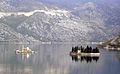 Saint-George andOur-Lady-of-the-Reef,two islands offPerast.
 -
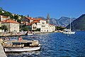 Town ofPerast,Kotor Municipality
 -
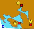 Bay of Kotor and Illyrian fortresses on the hills 1)Risan 2)Gosici 3)Kremalj (Mirac)
 -
 Kotor bay from St John Castle.
 -
 Stone lion and the Bay of Kotor. Perast, Montenegro.
 -
 The ancientfortifications of Kotor
 -
 Panorama of the Bay of Kotor
 -
 Kotor Bay, as seen from theLovćenmountain.
 -
 Kotor around 1840


See also
[edit]References
[edit]- ^"Welcome to Bay of Kotor".Lonely Planet.Retrieved14 January2020.
- ^D Magaš. "Natural-Geographic Characteristics of the Boka Kotosdka Area As the Basis of Development".GeoadriaVol. 7 No. 1, Croatian Geographical Society and University of Zadar Department of Geography, Zadar, 2002, pp. 53.
- ^"Late Holocene Glacial History of Sólheimajökull, Southern Iceland"(PDF).Archived fromthe original(PDF)on 2014-03-20.
- ^Hupchick, Dennis P.The Balkans: From Constantinople to Communism.Palgrave Macmillan, 2004.ISBN1-4039-6417-3
- ^Rastko.org,Arheologija 13047
- ^Serbian studies, Volumes 2–3,p. 29
- ^De originibus Slavicis,Volume 1 By Johann Christoph von Jordan,p. 155
- ^Lujo Margetić, Konstantin Porfirogenet i vrijeme dolaska Hrvata, Vol. 8, 1977.https://hrcak.srce.hr/83642#page=8
- ^Popović 2002,p. 173.
- ^Rick Steves Snapshot Dubrovnikby Rick Steves and Cameron Hewitt
- ^Ćirković 2004,p. 92.
- ^Ćirković 2004,p. 185.
- ^Miloš Milošević (1988).Hajduci u Boki Kotorskoj 1648–1718.CANU.ISBN9788672150148.
- ^Marko Jačov (1992).Le Missioni cattoliche nei Balcani durante la Guerra di Candia (1645–1669).Biblioteca apostolica vaticana. pp. 709–.ISBN978-88-210-0638-8.
- ^"MONTENEGRINA - digitalna biblioteka crnogorske kulture i nasljedja".
- ^Ćirković 2004,p. 187.
- ^Territorial proposals for the settlement of war in Bosnia Hercegovina - boundary and territorial briefing volume 1 number 3 page 12 by Mladen Klemencic
- ^Manuale del regno di Dalmazia[Handbook of the Kingdom of Dalmatia]. Battaro. 1872. p. 260.
- ^Handbook to the Mediterranean, Part 1.London: John Murray. 1881. p. 303.
- ^Bensman, Stephen (1962).The Russian Occupation of the Region of Kotor Bay, 1806-1807.University of Wisconsin-Madison. p. 7.
- ^"[Projekat Rastko – Boka] Simo Matavulj – Boka i Bokelji".rastko.org.rs.Archived fromthe originalon 24 September 2015.Retrieved31 May2015.
- ^"Census 2011 data - Municipalities".monstat.org.Statistical Office of Montenegro.
- ^"Slavni" Kapetani Boke kotorske "".Radio DUX.18 April 2013.Retrieved31 May2015.
- ^Petar Želalić famous naval captain, from Boka KotorskaArchivedApril 22, 2014, at theWayback Machine
Literature
[edit]- Ćirković, Sima(2004).The Serbs.Malden: Blackwell Publishing.ISBN9781405142915.
- Fine, John Van Antwerp Jr.(1991) [1983].The Early Medieval Balkans: A Critical Survey from the Sixth to the Late Twelfth Century.Ann Arbor, Michigan: University of Michigan Press.ISBN0472081497.
- Fine, John Van Antwerp Jr.(1994) [1987].The Late Medieval Balkans: A Critical Survey from the Late Twelfth Century to the Ottoman Conquest.Ann Arbor, Michigan: University of Michigan Press.ISBN0472082604.
- Popović, Svetlana (2002)."The Serbian Episcopal sees in the thirteenth century (Српска епископска седишта у XIII веку)".Старинар(51: 2001): 171–184.
- Boka kotorska: Etnički sastav u razdoblju austrijske uprave (1814.-1918. g.), Ivan Crkvenčić, Antun Schaller, Hrvatski geografski glasnik 68/1, 51–72 (2006)
42°26′N18°38′E/ 42.433°N 18.633°E
| International | |
|---|---|
| National | |
| Geographic | |