
Kukës County
Kukës County
Qarku i Kukësit(Albanian) | |
|---|---|
 | |
 Flag  Emblem | |
 Map of Albania with Kukës County highlighted | |
| Coordinates:42°10′N20°20′E/ 42.167°N 20.333°E | |
| Country | |
| Seat | Kukës |
| Subdivisions | |
| Government | |
| • Council chairman | Astrit Dobrushi(PAA)[1] |
| Area | |
| • Total | 2,374 km2(917 sq mi) |
| • Rank | 7th |
| Population (2021[2]) | |
| • Total | 74,388 |
| • Rank | 11th |
| • Density | 31/km2(81/sq mi) |
| Time zone | UTC+1(CET) |
| • Summer (DST) | UTC+2(CEST) |
| HDI(2021) | 0.754 high·12th of 12 |
| NUTS Code | AL013 |
| Website | www |
Kukës County(Albanian pronunciation:[kuːkəs];Albanian:Qarku i Kukësit) is a landlockedcountyin northeasternAlbania,with the capital inKukës.The county spans 2,374 square kilometres (917 sq mi) and had a total population of 74,388 people as of 2021.[2]The county borders on the counties ofDibër,LezhëandShkodërand the countries ofMontenegro,KosovoandNorth Macedonia.It is divided into threemunicipalities:Has,KukësandTropojë.[3]The municipalities are further subdivided into 290 towns and villages in total.
The human presence in the lands of modern Kukës County can be traced back to theBronze Ages,when ancientIllyrians,DardaniansandRomansestablished settlements in the region.[4]Several Illyriantombswere discovered in the villages of Këneta and Kolsh close toKukës.[5]
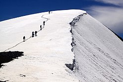
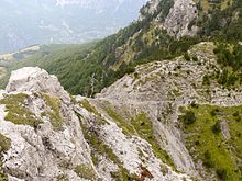
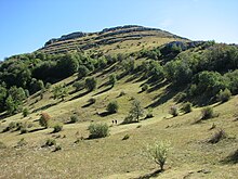
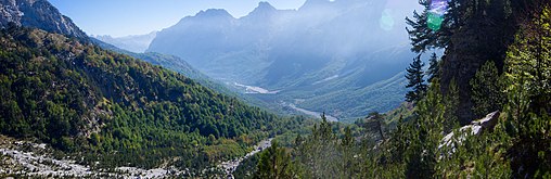
Kukës is predominantly mountainous and framed bymountain rangesincluding theAlbanian Alpsin the northwest which is typified bykarsttopography. The northeast is dominated by the mountains ofGjallica,KoritnikandPashtrik,while the southeastern bound is mostly formed by theKorabandSharr Mountains.[6]At 2,694 metres (8,839 ft),Maja Jezercëis the county's highest peak, and the second highest peak of Albania. Karst topography predominates in the county, resulting in specific landforms and hydrology because of the interaction of the karst and the region's watercourses. It is crossed and drained by theDrinriver. The county is also home to the sources of rivers such as theValbonawhich is part of Tropojë,originates south ofMaja JezercëandGashia notabletributaryof Valbona.
Located in thenorthof Albania, the climate isalpineandcontinental.[7][8]Mean monthly temperature ranges between 11°C(52°F) (in January) and 25 °C (77 °F) (in July). Mean annual precipitation ranges between 900 millimetres (35 inches) and 3,000 millimetres (120 inches) depending on geographic region and prevailing climate type.
According to the last national census from 2011 this county has 85,292 inhabitants. They are mostlyMuslim, with a small Shiite populationand a significantCatholic Christianminority are present. They speak theGheg dialect.
Geography
[edit]

Kukës is one of 12counties of Albania,located in the north and northeast of theNorthern Region.The county area is 2,374 km2(917 sq mi) and the seventh largest county by area in Albania and the third largest in the Northern Region, behindShkodër CountyandDibër County.It is bordered by the counties ofShkodër Countyin the west,Dibër Countyin the south,Lezhë Countyin the southeast, the countries ofSerbiain the east and northeast andMontenegroin the north and northwest. Its northernmost point is Çerem point at 42° 29' 52 "northern latitude; the southernmost isKalispoint at 41° 50' 0 "northern latitude; the westernmost point is Rrogam at 19° 50' 24" eastern longitude; and the easternmost point isShishtavecat 20° 36' 0 "eastern longitude.
The terrain of the county consists of small plains and high mountains. Elevations here range between 250 m (0.16 mi) and 2,200 m (1.4 mi).[9]TheAlbanian Alpsare a high mountain range running throughTropojëacross the northwest of the county. The northeast contain high and steep peaks includingGjallica,KoritnikandPashtrik.Between these mountains are mostly narrowvalleys,canyonsand ravines. From southeast, the county is crossed by theSharrandKorabMountains.
Hydrologically,the county lies almost entirely within the basin of theDrinand its tributaries. The river flows into theAdriatic Seaafter crossing the county territory from the confluence ofBlack DrinandWhite Drin.On their way, its basin and zone of influence naturally correspond to the areas destined for agricultural use. LakeFierzaandKomanlies in the county and are fed and drained by rivers Black Drin and White Drin. Other notable rivers includeGashiandValbona.
Phytogeographically,the county falls within theDinaric Mountains mixed forestsandBalkan mixed foreststerrestrialecoregionsof thePalearctictemperate broadleaf and mixed forest.The Balkan mixed forests occupy the eastern portion of the county. Inside the county, there are anational parks,anature parkand anature reserve,which include theValbonë Valley National Park,Korab-Koritnik Nature Parkand theGashi River Nature Reserve.The northern and eastern bound of the county forms a part of theEuropean Green Belt,which serves as a retreat forendangeredmammalandplantspecies.[10][11]Furthermore, theGashi Riverwas declared aUNESCOWorld Heritage Siteas part of thePrimeval beech forests of the Carpathians and other regions of Europe.[12]
Demographics
[edit]
With an estimated total population of around 85,292 people as of theINSTATcensus of 2011, Kukës is the second-to-last least populous county inAlbania.[13]The population density is 36 inhabitants per square kilometre (93/sq mi). Compared to 2001, the county had approximately 112,000 people. It has lost almost a quarter of its population in the last ten years. Kukës has the highest total fertility rate of Albania with 2.29 children per woman (compared to the national number of 1.54 children per woman).
The county is inhabited mostly byAlbanians(99.15%). Minority groups includeMacedonians(0.85%),Greeks(0.01%),Aromanians(0.01%) andEgyptians(0.00%).[14]Goranisare also present in the region of Shishtavec and surrounding region.
According to the 2011 census, 83.81% of the Albanian population within the county identify asMuslims.AlthoughChristianityis the second largest religion in Kukës. 2.72% identify themselves as Christians; of these,Roman Catholicsmake up the largest group, accounting for 2.62% of the population, after which followsEastern Orthodoxy(0.03%),Evangelicalor Protestant (0.03%), and other Christianity (0.04%). 0.33% of the population describes themselves as non-religious.[14]
There has been a surge of tourists ever since the grand opening ofKukës International Airport Zayedin 2021.[15][16]
Economy
[edit]Kukës County is Albania's poorest region both historically and presently.[17]Since the 1990s many of its inhabitants have migrated to Tirana or abroad. Prior to the collapse, Kukës industry was rug making, agriculture and textiles. However, since the 1990s much of Kukës population have migrated abroad, leaving to a decline in the local economy and making Kukës among Albania's and Europe's poorest regions and least developed.[18]However, in 2021,Edi Ramaopened up Albania's second international Airport in Kukës to revive the stagnant economy there. Nonetheless, Kukës remains three times poorer than the capital city of Tirana.
Gallery
[edit]-
-
-
 Source ofGashi
 -
-
-


See also
[edit]References
[edit]- ^https://a2news /2023/09/27/zgjidhet-kryetari-i-keshillit-te-qarkut-kukes/[bare URL]
- ^ab"Population on 1st January by prefecture and sex"(PDF).INSTAT.7 May 2021. p. 6.
- ^"Law nr. 115/2014"(PDF)(in Albanian). p. 6373.Retrieved25 February2022.
- ^Bulletin of the Institute of Archaeology,vol. 30–31, University of London. Institute of Archaeology, 1991, pp. 11–14
- ^Boardman, Edwards, John,I. E. S. (1982).The Cambridge Ancient History.Cambridge University Press. p. 235.ISBN9780521224963.Retrieved10 January2016.
{{cite book}}:CS1 maint: multiple names: authors list (link) - ^"STRATEGJIA TERRITORIALE E NJËSISË VENDORE KUKËS"(PDF).kukesi.gov.al.p. 14. Archived fromthe original(PDF)on 2017-10-03.Retrieved2017-10-02.
- ^"PLANI I ZHVILLIMIT I BASHKISE KUKES"(PDF).rasp.org.al(in Albanian). p. 14. Archived fromthe original(PDF)on 2017-10-14.
- ^"Zona Funksionale Tropojë"(PDF).km.dldp.al(in Albanian). p. 5.
- ^"Resurset kryesore te Qarkut te Kukesit".kqk.gov.al(in Albanian).
- ^European Green Belt."Brezi i Gjelbër Evropian"(PDF).europeangreenbelt.org(in Albanian). p. 2. Archived fromthe original(PDF)on 2015-10-18.Retrieved2018-12-29.
- ^Euronatur."BEECH FORESTS ALONG THE GREEN BELT ALBANIA"(PDF).euronatur.org.p. 2. Archived fromthe original(PDF)on 2021-08-31.Retrieved2017-09-29.
- ^"PËRSHKRIMI I RRJETIT AKTUAL TË ZONAVE TË MBROJTURA"(PDF).mjedisi.gov.al(in Albanian). p. 2. Archived fromthe original(PDF)on 2018-08-06.Retrieved2018-12-29.
PËRSHKRIMI I RRJETIT AKTUAL TË ZONAVE TË MBROJTURA
- ^INSTAT."Population and Housing Census"(PDF).instat.gov.al(in Albanian). p. 20. Archived fromthe original(PDF)on 2016-03-04.
- ^abINSTAT."Population and Housing Census"(PDF).instat.gov.al(in Albanian). p. 39. Archived fromthe original(PDF)on 2016-03-04.
- ^"Kukës Airport | AAC".Retrieved2023-01-27.
- ^Devarasetti, Hasini (2021-04-19)."Albania opens Kukes International Airport in Kukes".Airport Technology.Retrieved2023-01-27.
- ^News, Albanian (2021)."Poorest in Europe".
{{cite web}}:|last=has generic name (help) - ^HDI."HDI".
| |||||||||||||||||||||||||||
