Kyra Panagia
Native name: Κυρά Παναγιά | |
|---|---|
 | |
| Geography | |
| Coordinates | 39°20′N24°04′E/ 39.33°N 24.07°E |
| Archipelago | Sporades |
| Total islands | 2 |
| Highest elevation | 302 m (991 ft) |
| Highest point | Mt. Panagias |
| Administration | |
Greece | |
| Region | Thessaly |
| Regional unit | Sporades |
| Municipality | Alonnisos |
| Demographics | |
| Population | 2 (2011) |
| Additional information | |
| Postal code | 370 05 |
| Area code(s) | 24240 |
| Vehicle registration | BO |
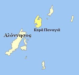
Kyra Panagia(Greek:Κυρά Παναγιά[ci'rapana'ʝa]) is aGreekislandin theSporadesarchipelago, in the northernAegean Sea.It is administratively part of the municipality ofAlonnisosin the Sporades regional unit. The island is also known by the name ofPelagosand rarelyPelagonisi.InAntiquityit was known asEphthyros(Έφθυρος) andPolyaigos(Πολύαιγος)[citation needed].A bay in the southwest of the island is namedAgios Petros.Kyra Panagia has belonged to theAthonitemonastery ofMegisti Lavra,located onMount Athos,since it was granted the island by the Byzantine emperorNikephoros II Phokasin 963. There is a monastery renovated in 2017 after 8 years of work and inhabited by a single monk, on the east coast of the island. As of 2011[update],the resident population of the island was 2.[1]Kyra Panagia is in Zone A[2]of theAlonnisos Marine Park.
Nearest islands and islets
[edit]Its nearest islands and islets areGiourato the northeast and the main island ofAlonnisosto the southwest.
References
[edit]- ^"Detailed census results 2011"(in Greek). National Statistical Service of Greece. Archived fromthe original(xls 2,7 MB)on 2013-12-25.
- ^http:// thalassafoundation[bare URL]
External links
[edit]


