
LaFayette, Alabama
LaFayette | |
|---|---|
 TheChambers County CourthouseSquare in LaFayette. | |
 Location of La Fayette in Chambers County, Alabama. | |
| Coordinates:32°53′54″N85°24′2″W/ 32.89833°N 85.40056°W | |
| Country | United States |
| State | Alabama |
| County | Chambers |
| Incorporated | January 7, 1835 |
| Named for | Marquis de Lafayette[1] |
| Government | |
| • Mayor | Kenneth Vines |
| Area | |
| • Total | 8.88 sq mi (23.01 km2) |
| • Land | 8.86 sq mi (22.94 km2) |
| • Water | 0.03 sq mi (0.07 km2) |
| Elevation | 843 ft (257 m) |
| Population (2020) | |
| • Total | 2,684 |
| • Density | 303.04/sq mi (117.00/km2) |
| Time zone | UTC−6(CST) |
| • Summer (DST) | UTC−5(CDT) |
| ZIP code | 36862 |
| Area code | 334 |
| FIPS code | 01-40672 |
| GNISfeature ID | 0164071 |
| Website | cityoflafayetteal |
LaFayette(/ləˈfeɪɛt,-ˈfaɪ-/lə-FAY-et, -FY-,/ˈlʌfeɪɛt/LUF-ay-et) is the county seat ofChambers County, Alabama,United States, 47 miles (76 km) northwest ofColumbus, Georgia.As of the2010 census,the population of the city was 3,003.[3]
History
[edit]Chambers County was formed in 1832. The newly elected county officials opted to locate the county seat as near as possible to the center of the county. Lots for the new town were auctioned in October 1833, with proceeds from the sale financing the construction of a courthouse and jail. The town was first called "Chambersville", but by the time of incorporation on January 7, 1835, the town name had been changed to "Lafayette", named after theMarquis de Lafayette;its spelling was changed to "LaFayette" due to the influence of newspaper editorJohnson J. Hooper,who created a fictional character called Captain Simon Suggs, a backwoods southerner who pronounced the town's name as "La Fait".[1][4]The city's newspaper,The LaFayette Sun,was founded under the nameThe Alabama Standardin April 1841 and adopted its current name on August 3, 1881.[5]
On October 2, 1898, John Anderson, a black man, was lynched in Lafayette.[6]Scenes from the movieMississippi Burningwere filmed at the Chambers County Courthouse and in downtown LaFayette.[1]
LaFayette is the birthplace ofheavyweight bo xing championJoe Louis.An 8-foot (2.4 m) bronze statue, executed by sculptor Casey Downing Jr. ofMobile, Alabama,was erected in Louis' honor in front of the Chambers County courthouse in 2010.[7]It is also the hometown ofHoyt L. Sherman,one of artistRoy Lichtenstein's principal art professor/mentors atOhio State University.
Geography
[edit]LaFayette is located at 32°53'54.859 "North, 85°24'2.822" West (32.898572, -85.400784).[8]
The city is located in east central Alabama alongU.S. Route 431,which is the main north–south route through the city. U.S. 431 leads north 21 mi (34 km) toRoanokeand south 23 mi (37 km) toOpelika.Alabama State Route 50also runs through the city as a southern bypass, leading east 14 mi (23 km) toLanetton the Alabama-Georgiastate line, and southwest 18 mi (29 km) toCamp Hill.Alabama State Route 77begins in the northern part of the city and connects LaFayette to the town ofWadley,20 mi (32 km) to the northwest.
According to theU.S. Census Bureau,the city has a total area of 8.9 square miles (23.0 km2), of which 0.027 square miles (0.07 km2), or 0.31%, is water.[3]
Climate
[edit]According to theKöppen climate classification,LaFayette has ahumid subtropical climate(abbreviatedCfa).
| Climate data for LaFayette, Alabama (1991–2020 normals, extremes 1944–present) | |||||||||||||
|---|---|---|---|---|---|---|---|---|---|---|---|---|---|
| Month | Jan | Feb | Mar | Apr | May | Jun | Jul | Aug | Sep | Oct | Nov | Dec | Year |
| Record high °F (°C) | 84 (29) |
86 (30) |
89 (32) |
93 (34) |
98 (37) |
103 (39) |
107 (42) |
105 (41) |
100 (38) |
99 (37) |
87 (31) |
81 (27) |
107 (42) |
| Mean daily maximum °F (°C) | 55.7 (13.2) |
60.0 (15.6) |
67.6 (19.8) |
75.0 (23.9) |
81.7 (27.6) |
87.0 (30.6) |
90.0 (32.2) |
88.9 (31.6) |
84.2 (29.0) |
75.0 (23.9) |
65.4 (18.6) |
57.5 (14.2) |
74.0 (23.3) |
| Daily mean °F (°C) | 42.9 (6.1) |
46.9 (8.3) |
53.5 (11.9) |
60.3 (15.7) |
68.5 (20.3) |
75.3 (24.1) |
78.7 (25.9) |
77.6 (25.3) |
72.4 (22.4) |
61.8 (16.6) |
51.4 (10.8) |
45.2 (7.3) |
61.2 (16.2) |
| Mean daily minimum °F (°C) | 30.2 (−1.0) |
33.8 (1.0) |
39.4 (4.1) |
45.7 (7.6) |
55.3 (12.9) |
63.5 (17.5) |
67.4 (19.7) |
66.3 (19.1) |
60.5 (15.8) |
48.6 (9.2) |
37.5 (3.1) |
32.8 (0.4) |
48.4 (9.1) |
| Record low °F (°C) | −7 (−22) |
3 (−16) |
8 (−13) |
25 (−4) |
34 (1) |
42 (6) |
53 (12) |
50 (10) |
37 (3) |
21 (−6) |
6 (−14) |
−1 (−18) |
−7 (−22) |
| Averageprecipitationinches (mm) | 5.70 (145) |
5.33 (135) |
5.70 (145) |
4.80 (122) |
4.40 (112) |
4.48 (114) |
4.80 (122) |
4.23 (107) |
3.53 (90) |
3.63 (92) |
4.31 (109) |
5.61 (142) |
56.52 (1,436) |
| Average precipitation days(≥ 0.01 in) | 10.4 | 9.6 | 9.4 | 8.8 | 8.7 | 10.5 | 11.0 | 10.2 | 7.0 | 7.2 | 7.6 | 9.9 | 110.3 |
| Source:NOAA[9][10] | |||||||||||||
Demographics
[edit]| Census | Pop. | Note | %± |
|---|---|---|---|
| 1860 | 1,113 | — | |
| 1870 | 1,382 | 24.2% | |
| 1880 | 1,061 | −23.2% | |
| 1890 | 1,369 | 29.0% | |
| 1900 | 1,629 | 19.0% | |
| 1910 | 1,632 | 0.2% | |
| 1920 | 1,911 | 17.1% | |
| 1930 | 2,119 | 10.9% | |
| 1940 | 2,138 | 0.9% | |
| 1950 | 2,353 | 10.1% | |
| 1960 | 2,605 | 10.7% | |
| 1970 | 3,530 | 35.5% | |
| 1980 | 3,647 | 3.3% | |
| 1990 | 3,151 | −13.6% | |
| 2000 | 3,234 | 2.6% | |
| 2010 | 3,003 | −7.1% | |
| 2020 | 2,684 | −10.6% | |
| U.S. Decennial Census[11] 2013 Estimate[12] | |||
2020 census
[edit]| Race | Num. | Perc. |
|---|---|---|
| White(non-Hispanic) | 710 | 26.45% |
| Black or African American(non-Hispanic) | 1,849 | 68.89% |
| Native American | 9 | 0.34% |
| Asian | 6 | 0.22% |
| Other/Mixed | 35 | 1.3% |
| HispanicorLatino | 75 | 2.79% |
As of the2020 United States census,there were 2,684 people, 1,017 households, and 610 families residing in the city.
2010 census
[edit]As of thecensus[14]of 2010, there were 3,003 people, 1,129 households, and 749 families residing in the city. The population density was 337 inhabitants per square mile (130/km2). There were 1,299 housing units at an average density of 145.9 square miles (378 km2). The racial makeup of the city was 68.8%BlackorAfrican American,29.3%White,0.1%Native American,0.4%Asian,0.8% fromother races,and 0.7% from two or more races. 1.9% of the population wereHispanicorLatinoof any race.
There were 1,129 households, out of which 23.4% had children under the age of 18 living with them, 29.6% were married couples living together, 30.7% had a female householder with no husband present, and 33.7% were non-families. 29.6% of all households were made up of individuals, and 13.2% had someone living alone who was 65 years of age or older. The average household size was 2.43 and the average family size was 2.98.
In the city, the age distribution of the population shows 22.0% under the age of 18, 9.8% from 18 to 24, 23.4% from 25 to 44, 26.8% from 45 to 64, and 18.0% who were 65 years of age or older. The median age was 40.2 years. For every 100 females, there were 87.1 males. For every 100 females age 18 and over, there were 103.5 males.
The median income for a household in the city was $26,319, and the median income for a family was $31,629. Males had a median income of $31,842 versus $27,833 for females. Theper capita incomefor the city was $12,149. About 28.5% of families and 36.2% of the population were below thepoverty line,including 43.2% of those under age 18 and 22.9% of those age 65 or over.
Education
[edit]TheChambers County School Districtprovides public education for LaFayette. Within the city limits are two high schools (Lafayette High School and the Chambers County Career Technical School), one middle school (JP Powell Middle School), and one elementary school (Eastside Elementary School).
Chambers Academy (grades pre-K through 12) is a private school in LaFayette.
Notable people
[edit]- Catharine Webb Barber,attended the Lafayette Female Seminary, at Chambers Court House; afterwards taught in the same institution
- William B. Bowling,U.S. Representative from 1920 to 1928
- Dave Butz,former NFL player
- James R. Dowdell,jurist and the 20thChief Justiceof theAlabama Supreme Courtfrom 1909 to 1914
- Morris Finley,professionalbasketballplayer. Graduated from LaFayette High School.
- Hal Finney,formerMajor League Baseballplayer
- Lou Finney,former Major League Baseball player
- Perry Griggs,formerBaltimore Coltsplayer
- James Thomas "Cotton Tom" Heflin,member of theUnited States House of Representativesand a leading proponent of white supremacy
- Johnson J. Hooper,author and humorist
- Jay Jacobs,former athletic director atAuburn University
- Joe Louis,Heavyweight bo xingchampion
- Leon Renfroe Meadows,president ofEast Carolina Universityfrom 1934 to 1944
- Arthur W. Mitchell,U.S. RepresentativefromIllinoisand firstAfrican Americanto be elected to theUnited States Congressas aDemocrat
- Gertrude Morgan,preacher, missionary, artist, musician, and poet who worked inNew Orleansin the 1960s and '70s
- Hoyt L. Sherman,art professor and principal mentor to pop artistRoy Lichtenstein
- Jimmy Stewart,former Major League Baseball player. Graduated from LaFayette High School in 1957.
- James Still,poet, novelist, and folklorist
- Mike Williams,formertight endfor theWashington Commanders
Gallery
[edit]-
 TheChambers CountyCourthousein LaFayette is featured prominently in the 1988 movieMississippi Burning.Chambers County Courthouse Square Historic District was added to theNational Register of Historic Placeson March 27, 1980.
 -
 LaFayette City Hall and Police Department.
 -
 LaFayette Post Office (ZIP code:36862)
 -
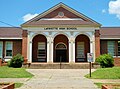 LaFayette High School
 -
 The Chambers County Museum is located in the former Central of Georgia railway depot. The depot was built of masonry construction with a tile roof in 1908 after fire destroyed the original wood structure.
 -
 The Ernest McCarty Oliver House was added to theNational Register of Historic PlacesJanuary 21, 1974.
 -
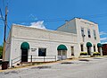
 Vines Funeral Home and Ambulance Service was added to theNational Register of Historic Placeson October 15, 2008.
 -
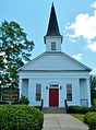 Built by early settlers to the area, the LaFayette Presbyterian Church has stood since 1836.
 -
 Downtown LaFayette, Alabama
 -
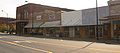 Downtown LaFayette, Alabama
 -
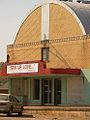 An old theatre in Downtown LaFayette most recently served as a church.
 -
 Statue ofLady Justicewhich tops thecourthouse
 -
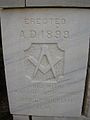 Thecornerstoneof the courthouse, laid byMasonsin 1899.
 -
 Aerial photograph of downtown LaFayette (note courthouse at center of photograph)


References
[edit]- ^abcSchmidt, Greg."LaFayette".Encyclopedia of Alabama.Archived fromthe originalon November 29, 2014.RetrievedJanuary 12,2010.
- ^"2020 U.S. Gazetteer Files".United States Census Bureau.RetrievedOctober 29,2021.
- ^ab"Geographic Identifiers: 2010 Demographic Profile Data (G001): La Fayette city, Alabama".U.S. Census Bureau, American Factfinder. Archived fromthe originalon February 12, 2020.RetrievedJune 2,2014.
- ^"Spell it with a capital 'F'".The LaFayette Sun blog.January 2, 2013.RetrievedJanuary 13,2013.
- ^"A History of The LaFayette Sun".The LaFayette Sun.August 22, 2012.RetrievedJanuary 13,2013.
- ^Ginzburg, Ralph (1996).100 Years of Lynchings.Black Classic Press. p. 253.ISBN9780933121188.
- ^Craft, Chris (February 27, 2010)."Joe Louis statue unveiled today will honor an icon".Ledger-Enquirer.Columbus, Georgia: McClatchy Company. Archived fromthe originalon February 22, 2012.RetrievedMarch 10,2010.
- ^"US Gazetteer files: 2010, 2000, and 1990".United States Census Bureau.February 12, 2011.RetrievedApril 23,2011.
- ^"NOWData - NOAA Online Weather Data".National Oceanic and Atmospheric Administration.RetrievedNovember 5,2023.
- ^"Summary of Monthly Normals 1991-2020".National Oceanic and Atmospheric Administration.RetrievedNovember 5,2023.
- ^"U.S. Decennial Census".Census.gov.RetrievedJune 6,2013.
- ^"Annual Estimates of the Resident Population: April 1, 2010 to July 1, 2013".Archived fromthe originalon May 22, 2014.RetrievedJune 3,2014.
- ^"Explore Census Data".data.census.gov.RetrievedDecember 13,2021.
- ^"U.S. Census website".United States Census Bureau.RetrievedJuly 10,2015.
External links
[edit]32°53′55″N85°24′03″W/ 32.898572°N 85.400784°W
Municipalities and communities ofChambers County, Alabama,United States | ||
|---|---|---|
| Cities |  | |
| Towns | ||
| CDPs | ||
| Unincorporated communities | ||
| Ghost town | ||
| Footnotes | ‡This populated place also has portions in an adjacent county or counties | |
| International | |
|---|---|
| National | |