
La Gleize
La Gleize
Li Gléjhe-dilé-Stoumont(Walloon) | |
|---|---|
 The village and its Romanesque church | |
 La Gleize La Gleize shown within Belgium | |
| Coordinates:50°25′N5°51′E/ 50.417°N 5.850°E | |
| Country | |
| Region | |
| Province | |
| Municipality | |
| Postal code | 4987 |
| Area code | 080 |
La Gleize(Walloon:Li Gléjhe-dilé-Stoumont) is a village ofWalloniaand a district of the municipality ofStoumont,located in theprovince of Liège,Belgium.
It was a municipality before the fusion of 1977. La Gleize is located on a rocky outcrop overlooking the valley ofAmblèvein theArdennesregion.
Hamlets
[edit]Moulin du Ruy, Andrimont, Ruy, Exbomont, Heilrimont, Moustier, Neufmoulin, Roanne, Roanne-Coo, Borgoumont, Courtyard, Cheneux, La Venne, Monceau.
Language
[edit]TheWalloondialect of La Gleize is one of the best researched in the area. This is due to the work of a native of the town,Louis Remacle,professor at theUniversity of Liègeand member of the Royal Academy of French Language and Literature of Belgium, who based part of his research there. HisSyntaxe du parler wallon de La Gleize(3 vols.) was a model forDialectology.
Sights
[edit]- The parish church
A Romanesque building of the 12th century, built in local stone, contains the red marble tomb of the Lords of Froidcourt. It was virtually rebuilt between 1945 and 1951: a photographic panel presents views from inside the church before the serious damage caused in 1944 by theBattle of the Bulge.
- December 44 Museum - The Battle of the Bulge
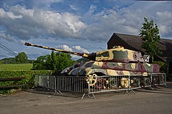
Established in the village square opposite the church. A 1000 m2 museum is devoted entirely to theBattle of the Bulgeof December 1944. La Gleize was where the advance ofKampfgruppe Peiperwas halted. A GermanTiger IItank is at the entrance of the building, inside is an abandoned reconnaissance armoredWillys Jeepin perfect condition.
Photos
[edit]-
-
 A GermanTiger IItank in front of the December 44 Museum.


External links
[edit]| International | |
|---|---|
| National | |