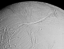
Labtayt Sulci
Appearance

Labtayt Sulciis a system of deep fractures onSaturn's moonEnceladus.Labtayt Sulci was first seen in low-resolutionVoyager 1images, but was observed in much more detail by theCassinispacecraft during its February 2005 flyby of Enceladus. It is centered at 28.0° SouthLatitude,284.0° WestLongitudeand is approximately 162 kilometers long, 4 kilometers wide, and 1 kilometer deep. The association between a cusp along the South Polar terrain boundary and Labtayt suggests that the fracture was forced open by thrust faulting where the fracture intersects withCashmere Sulci.[1]
Labtayt Sulci is named afterLabtayt,the capital ofRoumin the tale "The City of Labtayt",from the bookOne Thousand and One Nights.
Notes and references[edit]
- ^ Porco, C. C.;Helfenstein, P.; Thomas, P. C.; Ingersoll, A. P.; Wisdom, J.; West, R.; Neukum, G.; Denk, T.; Wagner, R. (10 March 2006)."Cassini Observes the Active South Pole of Enceladus"(PDF).Science.311(5766): 1393–1401.Bibcode:2006Sci...311.1393P.doi:10.1126/science.1123013.PMID16527964.S2CID6976648.
External links[edit]

