
Lages
Lages | |
|---|---|
| Municipality of Lages | |
 Flag  Seal | |
| Nickname: Princesa da Serra(Princess of the Serra) | |
 Location in thestate of Santa CatarinaandBrazil | |
| Coordinates:27°48′57″S50°19′33″W/ 27.81583°S 50.32583°W | |
| Country | Brazil |
| Region | South |
| State | Santa Catarina |
| Founded | November 22, 1776 |
| Government | |
| •Mayor | Antonio Ceron |
| Area | |
| • Total | 2,644.313 km2(1,643.099 sq mi) |
| Elevation | 916 m (3,005 ft) |
| Population (2022)[1] | |
| • Total | 164,981 |
| • Density | 62.55/km2(162.0/sq mi) |
| Time zone | UTC-3(UTC-3) |
| • Summer (DST) | UTC-2(UTC-2) |
| HDI(2010) | 0.770 –high[2] |
| Website | www |


Lagesis a Brazilianmunicipalitylocated in the central part of the state ofSanta Catarina,in the region known inPortugueseas "Planalto Serrano".
It is located in themountainregion of the state and is the largest municipality of it. It is the maincityof this region, and borders the towns ofOtacílio Costa,São Joaquim,andCorreia Pinto.The main course of urban water isCarahá River.
Lages hosts an annual festival calledFesta do Pinhão,that is famous throughout the country.
Economically, the city is known for its strong cattle breeding andwood processingfactories.
History
[edit]In the beginning of the 17th century, the arrival of the first Europeans established the town. The growing of Lages was due to the opening of roads to reach the fields ofRio Grande do Sul.The people ofSão PauloandMinas Geraiswere attracted to this region due to the cattle-breeding business with thegauchos.
Very primitive documents mention Lages as a stop for horse riders that were traveling fromSorocabaorSão Paulo,transporting mules, horses and cattle.Correia Pinto,the founder, was a horse rider, and ran cattle groups from Lages toSão Paulo.
In 1766, Lages becomes a village. In 1820 it detached itself fromSão Pauloto be part of the state ofSanta Catarina.On May 25, 1860, it was elevated to city status. In 1960, the city's current name was adopted.
During theRevolução Farroupilha,Lages belonged to theJuliana Republic.
Lages is served byAntônio Correia Pinto de Macedo AirportandPlanalto Serrano Regional Airportlocated in the adjoining municipality ofCorreia Pinto.
Geography
[edit]Lages is located in the mountain region of the state and is the largest municipality of it. It is the maincityof this region, and borders the towns ofOtacílio Costa,São Joaquim,andCorreia Pinto.The main course of urban water isCarahá River.
Climate
[edit]Lages has asubtropical highlandclimate (Koppen:Cfb), with an annual mean temperature of 16 °C (61 °F). Winter temperatures can stay below freezing, with occurrence of frost and snow. During the summer, temperatures may reach 30 °C (86 °F) and droughts may occur.
Records
[edit]Data byINMETshows that the lowest temperature recorded in the city between 1961 and 2017 was −6 °C (21 °F) on 14 July 2000[3]and the highest was 34.5 °C (94.1 °F) on 9 January 2006.[4]On 1 October 2001, the city accumulated a record of 177 millimetres (7.0 in) of precipitation in a period of 24 hours. Previous large accumulations include 122 millimetres (4.8 in) on 22 October 1979 and 117.2 millimetres (4.61 in) on 16 April 1971.[5]
With 671.4 millimetres (26.43 in), August 1983 was the month with the most accumulated precipitation.[6]The lowestrelative humidityobserved was of 20% on 13 November 1971.[7]
| Climate data for Lages (1991–2020 normals, extremes 1961–2017) | |||||||||||||
|---|---|---|---|---|---|---|---|---|---|---|---|---|---|
| Month | Jan | Feb | Mar | Apr | May | Jun | Jul | Aug | Sep | Oct | Nov | Dec | Year |
| Record high °C (°F) | 34.5 (94.1) |
34.3 (93.7) |
33.2 (91.8) |
30.8 (87.4) |
27.9 (82.2) |
25.6 (78.1) |
26.9 (80.4) |
31.0 (87.8) |
32.4 (90.3) |
32.6 (90.7) |
34.4 (93.9) |
33.9 (93.0) |
34.5 (94.1) |
| Mean daily maximum °C (°F) | 26.8 (80.2) |
26.6 (79.9) |
25.3 (77.5) |
22.6 (72.7) |
18.8 (65.8) |
17.3 (63.1) |
17.2 (63.0) |
19.4 (66.9) |
19.7 (67.5) |
21.7 (71.1) |
24.0 (75.2) |
26.1 (79.0) |
22.1 (71.8) |
| Daily mean °C (°F) | 20.6 (69.1) |
20.6 (69.1) |
19.2 (66.6) |
16.7 (62.1) |
13.0 (55.4) |
11.5 (52.7) |
11.1 (52.0) |
12.8 (55.0) |
13.9 (57.0) |
16.2 (61.2) |
17.9 (64.2) |
19.9 (67.8) |
16.1 (61.0) |
| Mean daily minimum °C (°F) | 16.3 (61.3) |
16.4 (61.5) |
15.2 (59.4) |
12.7 (54.9) |
9.1 (48.4) |
7.6 (45.7) |
7.0 (44.6) |
8.1 (46.6) |
9.8 (49.6) |
12.2 (54.0) |
13.4 (56.1) |
15.3 (59.5) |
11.9 (53.4) |
| Record low °C (°F) | 5.4 (41.7) |
7.0 (44.6) |
2.3 (36.1) |
−0.7 (30.7) |
−3.4 (25.9) |
−5.8 (21.6) |
−6.0 (21.2) |
−4.8 (23.4) |
−4.0 (24.8) |
0.2 (32.4) |
2.9 (37.2) |
3.2 (37.8) |
−6.0 (21.2) |
| Averageprecipitationmm (inches) | 177.6 (6.99) |
167.0 (6.57) |
126.6 (4.98) |
115.1 (4.53) |
120.7 (4.75) |
126.7 (4.99) |
159.3 (6.27) |
125.6 (4.94) |
175.0 (6.89) |
201.4 (7.93) |
138.1 (5.44) |
149.1 (5.87) |
1,782.2 (70.17) |
| Average precipitation days(≥ 1.0 mm) | 13 | 12 | 10 | 8 | 8 | 8 | 9 | 8 | 10 | 12 | 10 | 11 | 119 |
| Averagerelative humidity(%) | 78.8 | 80.1 | 80.6 | 81.8 | 84.1 | 85.5 | 84.0 | 80.1 | 80.6 | 81.1 | 77.1 | 76.6 | 80.9 |
| Mean monthlysunshine hours | 199.8 | 173.8 | 181.2 | 158.9 | 145.4 | 128.6 | 145.5 | 166.8 | 141.6 | 150.4 | 195.7 | 195.1 | 1,982.8 |
| Source:Instituto Nacional de Meteorologia[8][9][10][11][12][13][14][15]Absolute temperature records: 1 January 1961 to 3 April 2017)[3][4] | |||||||||||||
Neighborhoods
[edit]Lages contains seventy-two neighborhoods:[16]
- Araucária[17]
- Área Industrial
- Bates
- Beatriz
- Bela Vista
- Bom Jesus
- Boqueirão[18]
- Brusque
- Caça e Tiro
- Caravágio
- Caroba
- CDL
- Centenário
- Centro
- Cidade Alta
- Chapada
- Conta Dinheiro
- Copacabana
- Coral
- Conte
- Cruz de Malta
- Dom Daniel[19]
- Ferrovia
- Frei Rogério[20]
- Gethal
- Gralha Azul
- Guadalupe
- Guadalajara
- Guarujá
- Golin
- Habitação
- Ipiranga
- Jardim Celina
- Jardim das Camélias
- Jardim Panorâmico
- Maria Luiza
- Morro do Posto
- Morro Grande
- Nossa Senhora Aparecida
- Passo Fundo
- Penha
- Petrópolis
- Pisani
- Ponte Grande[21][22]
(Jardim Cepar)
(Avenida Corina Caon) - Popular
- Pró-Morar
- Restinga Seca
- Sagrado Coração de Jesus
- Santa Catarina
- Santa Cândida
- Santa Clara
- Santa Helena
- Santa Maria
- Santa Mônica[23]
- Santa Rita
- Santo Antônio
- São Cristóvão
- São Francisco
- Salto Caveiras
- São Luiz
- São Miguel
- São Paulo
- São Pedro
- São Sebastião
- Triângulo
- Tributo
- Universitário
- Várzea
- Vila Comboni
- Vila Maria
- Vila Mariza
- Vila Nova
- Vista Alegre[24]
Gallery
[edit]-
 View of theCatedral Diocesana
 -
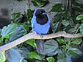 The azure jay (gralha azul) is the city bird


References
[edit]- ^"Population".Instituto Brasileiro de Geografia e Estatística.Retrieved16 February2024.
- ^"Ranking - Índice de Desenvolvimento Humano Municipal - 2010"(PDF).United Nations Development Programme(UNDP). Archived fromthe original(PDF)on July 8, 2014.RetrievedAugust 1,2013.
- ^ab"BDMEP - série histórica - dados diários - temperatura mínima (°C) - Lages".Instituto Nacional de Meteorologia.Retrieved17 July2015.
- ^ab"BDMEP - série histórica - dados diários - temperatura máxima (°C) - Lages".Instituto Nacional de Meteorologia.Retrieved17 July2015.
- ^"BDMEP - série histórica - dados diários - precipitação (mm) - Lages".Instituto Nacional de Meteorologia.Retrieved17 July2015.
- ^"BDMEP - série histórica - dados mensais - precipitação total (mm) - Lages".Instituto Nacional de Meteorologia.Retrieved2 May2014.
- ^"BDMEP - série histórica - dados horários - umidade relativa (%) - Lages".Instituto Nacional de Meteorologia.Retrieved17 July2015.
- ^ "Temperatura Máxima Mensal e Anual (°C)".Normais Climatológicas do Brasil 1991-2020(in Portuguese). Instituto Nacional de Meteorologia. Archived fromthe originalon 24 March 2022.Retrieved20 May2024.
- ^ "Temperatura Média Compensada Mensal e Anual (°C)".Normais Climatológicas do Brasil 1991-2020(in Portuguese). Instituto Nacional de Meteorologia. Archived fromthe originalon 24 March 2022.Retrieved20 May2024.
- ^ "Temperatura Mínima Mensal e Anual (°C)".Normais Climatológicas do Brasil 1991-2020(in Portuguese). Instituto Nacional de Meteorologia. Archived fromthe originalon 24 March 2022.Retrieved20 May2024.
- ^ "Precipitação Acumulada Mensal e Anual (mm)".Normais Climatológicas do Brasil 1991-2020(in Portuguese). Instituto Nacional de Meteorologia. Archived fromthe originalon 24 March 2022.Retrieved20 May2024.
- ^ "Número de dias no mês ou no ano com precipitação maior ou igual a (1 mm) (dias)".Normais Climatológicas do Brasil 1991-2020(in Portuguese). Instituto Nacional de Meteorologia. Archived fromthe originalon 24 March 2022.Retrieved20 May2024.
- ^ "Umidade Relativa do Ar Compensada Mensal e Anual (%)".Normais Climatológicas do Brasil 1991-2020(in Portuguese). Instituto Nacional de Meteorologia. Archived fromthe originalon 24 March 2022.Retrieved20 May2024.
- ^ "Insolação Total (horas)".Normais Climatológicas do Brasil 1991-2020(in Portuguese). Instituto Nacional de Meteorologia. Archived fromthe originalon 24 March 2022.Retrieved20 May2024.
- ^"Normais Climatológicas do Brasil".Instituto Nacional de Meteorologia.Retrieved13 May2018.
- ^"Bairros da cidade Lages".Guia Mais.Archivedfrom the original on 20 February 2017.
- ^"Araucária, Lages".City Facts.Archivedfrom the original on 29 October 2021.
- ^"Boqueirão, Lages".City Facts.Archivedfrom the original on 29 October 2021.
- ^"Dom Daniel, Lages".City Facts.Archivedfrom the original on 29 October 2021.
- ^"Frei Rogério, Lages".City Facts.Archivedfrom the original on 7 November 2021.
- ^"Ponte Grande, Lages".City Facts.Archivedfrom the original on 29 October 2021.
- ^"Pte. Grande".Google maps.
- ^"Santa Mônica, Lages".City Facts.Archivedfrom the original on 3 November 2021.
- ^"Vista Alegre, Lages".City Facts.Archivedfrom the original on 3 November 2021.
External links
[edit]- Lages City HallArchived2017-04-14 at theWayback Machine
- Festa do Pinhão official site
Capital:Florianópolis | |||||||||
| Grande Florianópolis |
|  | |||||||
| Norte Catarinense |
| ||||||||
| Oeste Catarinense | |||||||||
| Serrana |
| ||||||||
| Sul Catarinense |
| ||||||||
| Vale do Itajai |
| ||||||||