
Lake Zurich
| Lake Zurich | |
|---|---|
| Zürichsee(German) | |
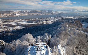
 Lake Zurich,Pfannenstiel,andSihl Valley,as seen fromFelsenegg | |
 Lake Zurich  Lake Zurich  Lake Zurich  Lake Zurich  Lake Zurich | |
 | |
| Coordinates | 47°14′51″N8°40′39″E/ 47.24750°N 8.67750°E |
| Primary inflows | Linth(Linthkanal) |
| Primary outflows | Limmat |
| Catchment area | 1,829 km2(706 sq mi) |
| Basincountries | Switzerland |
| Max. length | 40 kilometres (25 miles) |
| Max. width | 3 kilometres (2 miles) |
| Surface area | 88.66 square kilometres (34.23 square miles) |
| Average depth | 49 metres (161 feet) |
| Max. depth | 136 metres (446 feet) |
| Water volume | 3.9 km3(0.94 cu mi) |
| Residence time | 440 days |
| Surface elevation | 406 m (1,332 ft) |
| Frozen | 1929, 1962/1963 (last) |
| Islands | Lützelau,Schönenwerd,Saffa,Ufenau |
| Sections/sub-basins | Obersee |
| Settlements | seelist |
 | |
Lake Zurich(German:Zürichsee;Swiss German/Alemannic:Zürisee)[1]is alakeinSwitzerland,extending southeast of the city ofZürich.Depending on the context, Lake Zurich orZürichseecan be used to describe the lake as a whole, or just that part of the lake downstream of the Hurden peninsula andSeedammcauseway (betweenPfäffikonandRapperswil). In the latter case, the upstream part of the lake is calledObersee(lit. 'Upper Lake'), whilst the lower part is sometimes also referred to as the Lower Lake (unterer Zürichsee), respectively.
Geography
[edit]Lake Zurich is aglacial lakethat was formed by theRhine-Linth glacier.Its maintributaryis the RiverLinth,which rises in theglaciersof theGlarus Alps.The Linth originally flew directly into Lake Zurich, but was later diverted by theEschercanal (completed in 1811) intoLake Walen(Walensee) from where its waters are now carried to the east end of Lake Zurich (nearSchmerikon) by means of the straightened Linthcanal(completed in 1816). Until the early 16th century, there was another lake upstream ofObersee,Lake Tuggen(Tuggenersee) nearTuggen.The waters of Lake Zurich flow out of the lake at its north-west end (at the level of theQuaibrücke), passing through the city of Zürich; however, the outflow is then called theLimmat.The Limmat is a tributary of theAare,which itself is a tributary of theHigh Rhine.[2]The culminating point of the lake's drainage basin is theTödiat 3,614 metres above sea level.[3]
Besides the River Linth, other tributaries are theJona,Schmerikoner Aa,SteinenbachandWägitaler Aa,which all flow out intoObersee,along with several creeks.[2]TheSeedamm,an artificial causeway and bridge, crosses the narrowest point of the lake at the level of theHurden Peninsula,carrying arailway lineand road fromRapperswiltoPfäffikon.The waterway is also crossed by theHolzbrücke Rapperswil-Hurden,a wooden pedestrian bridge. The eastern section of the lake is known as theObersee(lit. 'Upper Lake'). West of the Seedamm lie the small islands ofLützelauandUfenau,where in 1523Ulrich von Huttentook refuge and died. Other islands includeGrosser Hafner,Saffa Islandand Schönenwerd (nearRichterswil). A popular tourist destination is theAu peninsulaat the village ofAubetweenWädenswilandHorgen.The lake shores are well cultivated and fertile.[2]They includenature reserves,such asFrauenwinkelorBätzimatt.The bay of Rapperswil andreedinNuolenare wintering areas for birds and popular sites forbird watching.
To the east, separated byZürichberg-Adlisberg,Forch,andPfannenstiel,are two smaller lakes,Greifensee(lit. 'Lake Greifen') andPfäffikersee(lit. 'Lake Pfäffikon'). There are several minor lakes andpondsin the vicinity, such asEgelsee,LützelseeorTürlersee.Zimmerberg,EtzelandBuechbergmountains lie to the west and south of the lake, respectively. Further to the east, theSpeer,ChüemettlerandFederispitzcan be seen from the southern part of the lake.
Administratively, Lake Zurich is split between the cantons ofZürich(Horgen District),St. Gallen(See-Gaster) andSchwyz(HöfeandMarchdistricts). The lower lake, to the west of the Seedamm, is largely in the canton of Zürich, whilst the upper lake is shared between the cantons of St. Gallen and Schwyz.
Tributaries of lower lake
[edit]The following rivers or streams flow into lower part of Lake Zurich.[4]From the Limmat clockwise, they are:

- Hornbach (atZürichhorn)
- Düggelbach (atZollikon)
- Kusenbach (atKüsnacht)
- Küsnachter Dorfbach(at Hornelanpark, Küsnacht)
- Heslibach (atErlenbach)
- Dorfbach Erlenbach (at Erlenbach)
- Tobelbächli (at Erlenbach)
- Schipfbach (at Erlenbach)
- Rossbach (atHerrliberg)
- Meilener Dorfbach (atMeilen)
- Beugenbach (at Meilen)
- Aebletenbach (at Ländeli, Meilen)
- Uetiker Mulibach (at Meilen)
- Feldbach (atHorn)
- Sarenbach (atFreienbach)
- Krebsbach (at Bäch, Freienbach)
- Mülibach (atRichterswil)
- Zürichsee (atWädenswil)
- Meilibach (at Wädenswil)
- Schanzengraben (Zürich)
Coastal settlements
[edit]Zürich,at the north-western end of the lake, is the largest city on Lake Zurich. The least populous isHurden.
On the west shore (which gradually becomes the south shore) areKilchberg,Rüschlikon,Thalwil,Oberrieden,Horgen,Au,WädenswilandRichterswilin thecanton of Zürich,andFreienbach,Pfäffikon,Hurden,Altendorf,Lachen,NuolenandTuggenin thecanton of Schwyz.
On the opposite shore, which gradually becomes the northern shore towards east, areZollikon,Küsnacht,Erlenbach,Herrliberg,Feldmeilen,Meilen,Stäfa,andFeldbachin the canton of Zürich, andRapperswil-Jona.The latter includes the medieval town ofRapperswil,whose castle is home to thePolish museum,and the coastal villages ofKempraten,BusskirchandBollingen.The municipalities of Rapperswil-Jona andSchmerikon,which is close to the east end of the lake, are both in thecanton of St. Gallen.A little further east is the larger town ofUznach.

Prehistoric pile dwellings and historic settlements
[edit]NinePrehistoric pile dwellings around Zürichsee,which are located in thecantonsofSchwyz,St. GallenandZürich,are among the 56Prehistoric pile dwellings around the Alpsin Switzerland.[5][6]
These nine sites on the Lake Zurich lakeshore areFreienbach–Hurden Rosshorn,Freienbach–Hurden Seefeld,Rapperswil-Jona/Hombrechtikon–Feldbach,Rapperswil-Jona–Technikum,Erlenbach–Winkel,Meilen–Rorenhaab,Wädenswil–Vorder Au,Zürich–Enge Alpenquai,andKleiner Hafner.Because the lake has grown in size over time, the original piles are now around 4 metres (13 ft) to 7 metres (23 ft) under the water level of 406 metres (1,332 ft). Two other sites are not far away:Greifensee–Storen/Wildsbergat the Greifensee andWetzikon–Robenhausenat the Pfäffikersee.
As well as being part of the 56 Swiss sites of the UNESCO World Heritage Site, each of these 11 prehistoric pile dwellings is also listed as aClass objectin theSwiss inventory of cultural property of national and regional significance.[7]
InKempraten(Rapperswil-Jonamunicipality), there was aRomanvicusnamedCentum Prata.Another settlement wasTuricumin Zürich.
Transportation
[edit]The main transportation nodes around the lake are Zürich and — given the presence of theSeedammcauseway —PfäffikonandRapperswil.BesidesQuaibrückein Zürich and the Seedamm, there are no bridges across the lake. In addition, the towns ofMeilenandHorgenare connected by acar ferry.
Trams and buses
[edit]Bus routes on the western shore are operated byZimmerberg Bus.On the eastern side, theVZOprovides bus services along the lake shore and to theZürcher Oberland.VZO also operates the urban bus routes in Rapperswil andJona.At the northern end of the lake, in Zürich, public transport consists oftrams,trolleybusesand busses ofVBZ.
Rail
[edit]Left bank:The towns on the western and southern shores of Lake Zurich are linked by theLake Zurich left bank railwayline, which connectsZürich HBwithZiegelbrücke.This line is served by theS2,S8,S24andS25of theZürich S-BahnandInterRegio(IR) trains. It is also used byEuroCity(EC),Intercity Express(ICE),Intercity(IC) andRailjet(RJX) trains but they do not call at stations along the lake. AtWädenswil,the line connects to theWädenswil–Einsiedeln railwaytoEinsiedeln,served by theS13.
Right bank:Towns on the eastern shore of the lower lake (also known as theGoldcoast,orGoldküste) are connected by theLake Zurich right bank railwayline between Zürich HB andRapperswil.This line is served byS-BahnservicesS6,S7,S16andS20of Zürich S-Bahn.
TheRapperswil–Ziegelbrücke railwayline along the northern shore of Obersee is served bySt. Gallen S-BahnservicesS4,S6andS17,and theVoralpen Express.This line connects Rapperswil withSchmerikonon the eastern end of the lake viaBlumenau.Bollingenis aghost stationsince 2004.
Seedamm:TheRapperswil–Pfäffikon railwayline across the Seedamm and Hurden Peninsula is served by Zürich S-Bahn servicesS5andS40and the Voralpen Express. This short line connects Rapperswil withPfäffikon SZviaHurden.
Shipping
[edit]TheZürichsee-Schifffahrtsgesellschaft–lit. 'the Lake Zurich Navigation Company'– provides with its 17-passenger ships touristic services on Lake Zurich. There are a number of passengerferryservices, notably theHorgen–Meilen ferry,anauto ferrybetweenHorgenandMeilen.
Freeze over
[edit]
The freezing of Lake Zurich, calledSeegfrörniinSwiss German,is a rare and spectacular event. The lake was frozen in the followingCommon Era/Anno Dominiyears (1963 was the last time):[8]
- 1223, 1259, 1262
- 1407, 1491
- 1514, 1517, 1573
- 1600, 1660, 1684, 1695
- 1709, 1716, 1718, 1740, 1755, 1763, 1789
- 1830, 1880, 1891, 1895
- 1929, 1963
Water quality
[edit]Lake Zurich's water is very clean and reaches, during summer, temperatures well beyond 20 °C (68 °F). Swimming in thepublic bathsand beaches is very popular. The lake's water is purified and fed into Zürich's water system; it is potable.

Gallery
[edit]-
 View from the top of the observation tower at Uetliberg.
 -
 View fromFelseneggto the eastern part of Lake Zürich
 -
 Ufenauisland
 -

-
-
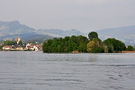 LützelauandRapperswil,view from Ufenau island
 -
-
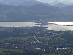
 Zurisee from an airplane
 -
 Schönenwerd island near Richterswil
 -
 Bank path and pedestrian bridge near Richterswil
 -
 Wooden pedestrian bridge near Rapperswil
 -
 Small islands near Jona delta


See also
[edit]- Obersee (Zürichsee)
- Prehistoric pile dwellings around Zürichsee
- Paddle steamer Stadt Rapperswil
- Paddle steamer Stadt Zürich
- Radio Zürisee
- Seedamm
- Zürichsee-Zeitung
- List of lakes of Switzerland
References
[edit]- ^"National Map 1:50 000"(Map).Zürichsee(2011 ed.). 1:50 000. "National Map 1:50'000, 78 sheets and 25 composites". Bern, Switzerland: Swiss Federal Office of Topography,swisstopo.16 January 2014. § "5011 Zürichsee - Zug".ISBN978-3-302-05011-9.Retrieved1 December2014.
- ^abcOne or more of the preceding sentences incorporates text from a publication now in thepublic domain:Coolidge, William Augustus Brevoort(1911). "Zürich, Lake of".InChisholm, Hugh(ed.).Encyclopædia Britannica.Vol. 28 (11th ed.). Cambridge University Press.
- ^"National Map 1:25 000"(Map).Tödi, Lake Zurich's culmination point(2009 ed.). 1:25 000. "National Map 1:25'000, 247 sheets and 17 composites". Bern, Switzerland: Swiss Federal Office of Topography, swisstopo. 16 January 2014. § "1193 Tödi".ISBN978-3-302-05011-9.Retrieved1 December2014.
- ^Bradshaw's pedestrian route-book for Switzerland, Chamouni, and the Italian lakes,George Bradshaw (1868)
- ^"Prehistoric Pile Dwellings in Switzerland".Swiss Coordination Group UNESCO Palafittes (palafittes.org). Archived fromthe originalon 7 October 2014.Retrieved7 December2014.
- ^"World Heritage".palafittes.org. Archived fromthe originalon 9 December 2014.Retrieved10 December2014.
- ^"A-Objekte KGS-Inventar".Schweizerische Eidgenossenschaft, Amt für Bevölkerungsschutz. 2009. Archived fromthe originalon 28 June 2010.Retrieved10 December2014.
- ^"The year Lake Zurich froze over".nationalmuseum.ch. 1 February 2023.Retrieved19 June2024.
External links
[edit]- Peter Ziegler:ZürichseeinGerman,FrenchandItalianin the onlineHistorical Dictionary of Switzerland,28 February 2014.
- Zürichsee Schifffahrtsgesellschaft—Boat schedules, mainly non-English.
- Zürichsee-Fähre Horgen-Meilen—Ferry schedules, in German.
- Waterlevels Lake ZürichatZürich
- Lake Zurich ENC Chart
| Settlements |
|  | |||
|---|---|---|---|---|---|
| Islands | |||||
| Rivers | |||||
| Valleys | |||||
| Mountains | |||||
| Landmarks |
| ||||
| Transportation | |||||
| People |
| ||||
| Espace Mittelland |  | |
|---|---|---|
| Nationwide | ||
Lakes of Switzerland | ||
|---|---|---|
| Major lakes |
|  |
| Lists | ||