
Leh
Leh | |
|---|---|
City | |
      From the top clockwise:Leh city aerial view,Sankar Monastery,Leh Palace,Old city,Shanti Stupa,Spring in Leh | |
 Interactive map of Leh | |
| Coordinates:34°09′51″N77°35′05″E/ 34.16417°N 77.58472°E | |
| Country | India |
| Union Territory | Union TerritoryofLadakh |
| District | Leh |
| Government | |
| • Type | Ladakh Autonomous Hill Development Council, Leh |
| Area | |
| • Total | 9.15 km2(3.53 sq mi) |
| Elevation | 3,500 m (11,500 ft) |
| Population (2011) | |
| • Total | 30,870 |
| • Density | 3,400/km2(8,700/sq mi) |
| Demographics | |
| • Languages | Ladakhi,Balti,Hindi,English[1] |
| Time zone | UTC+5:30(IST) |
| Vehicle registration | LA 02 |
| Website | leh |
Leh(/ˈleɪ/)[2]is a city inLadakhin theHimalayan region.[3]It is the largest city and the joint capital of Ladakh.[4]Leh, located in theLeh district,was also the historical capital of theKingdom of Ladakh.The seat of the kingdom,Leh Palace,the former residence of the royal family of Ladakh, was built in the same style and about the same time as thePotala PalaceinTibet.[citation needed]Since they were both constructed in a similar style and at roughly the same time, the Potala Palace in Tibet and Leh Palace, the royal residence, are frequently contrasted. Leh is at an altitude of 3,524 m (11,562 ft), and is connected viaNational Highway 1toSrinagarin the southwest and toManaliin the south via theLeh-Manali Highway(part ofNational Highway 3).
Etymology
[edit]This section is empty.You can help byadding to it.(June 2024) |
History
[edit]
Leh was for centuries an important stopover ontrade routesalong theIndus ValleybetweenTibet,Kashmir,India andChina.The main goods carried were salt, grain,pashmorcashmere wool,charasorcannabisresin from theTarim Basin,indigo,silkyarn andBanarasbrocade.
Although there are a few indications that the Chinese knew of a trade route through Ladakh to India as early as theKushanperiod (1st to 3rd centuries AD),[5]and certainly by theTang dynasty,[6]little is actually known of the history of the region before the end of the 10th century, when Tibetan princeSkyid lde nyima gon(orNyima gon), a grandson of the anti-Buddhist Tibetan king,Langdarma(r. c. 838 to 841), founded the kingdom. He conquered Western Tibet, although his army originally numbered only 300 men.[citation needed]Several towns and castles are said to have been founded by Nyima gon, and he apparently ordered the construction of the primary sculptures atShey."In an inscription, he says he had them made for the religious benefit of theTsanpo(the dynastical name of his father and ancestors), and of all the people ofNgaris(Western Tibet). This shows that already in this generation Langdarma's opposition toBuddhismhad disappeared. "[7]Shey,15 km east of modern Leh, was the ancient seat of the Ladakhi kings.
During the reign of Delegs Namgyal (1660–1685),[8]thenawabof Kashmir, then a province in theMughal Empire,arranged for the Mongol army to temporarily leave Ladakh, though it returned later. As payment for assisting Delegs Namgyal in theTibet-Ladakh-Mughal Warof 1679–1684, the nawab made a number of onerous demands. One of the least was construction of a largeSunni Muslimmosque in Leh, at the upper end of the bazaar in Leh below Leh Palace. The mosque reflects a mixture ofIslamicand Tibetan architecture and can accommodate more than 500 people. This was apparently not the first mosque in Leh; there are two smaller ones that are said to be older.[9]
Trade routes have traditionally converged on Leh from all four directions. The modern-day highway follows the most direct route from thePunjabviaMandi,theKulu valley,theRohtang Pass,andLahaulto the Indus Valley, then downriver to Leh. The route from Srinagar was roughly the same as the road that today crosses theZoji La(pass) toKargil,then up the Indus Valley to Leh. FromBaltistanthere were two difficult routes: the main one ran up the Shyok Valley from the Indus, over a pass and then down the Hanu River to the Indus again belowKhalsi(Khalatse). The other ran fromSkardustraight up the Indus to Kargil and on to Leh. Both summer and winter routes ran from Leh toYarkandvia theKarakoram PassandXaidulla.A couple of possible routes also ran from Leh toLhasa.[10]
The first recorded royal residence in Ladakh, built at the top of the high Namgyal ('Victory') Peak overlooking the present palace and town, is the now-ruined fort andgon-khang(Temple of the Guardian Divinities) built by KingTashi Namgyal.Tashi Namgyal ruled in the final quarter of the 16th century CE.[11]The Namgyal (also called "Tsemo Gompa" (Red Gompa), ordGon-pa-so-ma(New Monastery),[12]a temple, is the main Buddhist centre in Leh.[13]There are some older walls of fortifications behind it which Francke reported were once known as the "Dard Castle." If it was indeed built byDards,it must pre-date the establishment of Tibetan rulers in Ladakh over a thousand years ago.[14]
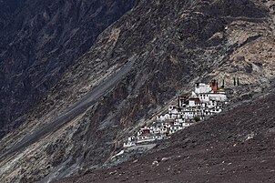
The Sankar Labrang (Bsam dkar bla brang) is a small, two-storeyed building owned bySankar monastery.Sankar monastery is the seat of Bakula Rinpoche, immediately to the northwest of Leh. The monastery's Labrang building is located in the old town of Leh, in the Manikhang neighbourhood. Manikhang is the area between the main bazaar of Leh and the historic Stalam path that leads up to the royal palace. Four hugestūpasstanding at this point mark the beginning of historic Leh. In recent memory, the Sankar Labrang had a metalsmith's workshop downstairs, while upstairs lived the monk caretaker of the White Maitreya Temple (Byams khang dkar po), also known locally as "Street Maitreya". The White Maitreya Temple dates back to the reign of King Drakpa Bumd´e (Grags pa 'bum lde, r. ca 1410–1435), following the arrival of a mission sent to Ladakh by the Tibetan lamaTsongkhapa.[15]
Below this are the Chamba (Byams-pa,i.e.,Maitreya) and Chenresi (sPyan-ras-gzigs, i.e.Avalokiteshvara) monasteries which are of uncertain date.[12]
Leh Palace
[edit]
Theroyal palace,known asLeh Palace,was built by KingSengge Namgyal(1612–1642),[16]presumably between the period when the PortugueseJesuitpriest Francisco de Azevedo visited Leh in 1631, and made no mention of it, andSengge Namgyal'sdeath in 1642.[17]
The Leh Palace is nine storeys high; the upper floors accommodated the royal family, and the stables and storerooms are located on the lower floors. The palace was abandoned whenKashmiriforces besieged it in the mid-19th century. The royal family moved their premises south to their current home inStokPalace on the southern bank of the Indus River.
- As has already been mentioned, the original name of the town was notsLel,as it is nowadays spelled, butsLes,which signifies an "encampment of nomads". These [Tibetan] nomads probably visited the Leh valley at when it began to be irrigated by Dard colonisers. The most ancient part of the ruins, atop rNam-rgyal-rtse-mo hill, are called 'aBrog-pal-mkhar (Dard castle).[18]
In 2010, Leh was heavily damaged bythe sudden floodscaused by acloud burst.
Administration
[edit]TheLadakh Autonomous Hill Development Council(LAHDC) is in charge of governance in Leh.
It has 30 councillors, 4 nominated and 26 elected. The Chief Executive Councillor heads and chairs this council. The Deputy Commissioner of Leh also holds the power of Chief Executive Officer of the LAHDC. The current Deputy Commissioner of Leh district is Santosh Sukhdeve.[citation needed]

Leh Old Town
[edit]
The old town of Leh was added to theWorld Monuments Fund's list of 100 most endangered sites due to increased rainfall, due to climate change among other reasons.[19]Neglect and changing settlement patterns in the old town have also threatened the long-term preservation of the site.[20]
The rapid and poorly planned urbanisation of Leh has increased the risk of flash floods in some areas, while other areas, according to research by theClimate and Development Knowledge Network,suffer from the less dramatic, gradual effects of 'invisible disasters', which often go unreported.[21]
Geography
[edit]
The city is located on the bank of the Indus River. The mountains dominate the landscape around the Leh, as it is at an altitude of 3,500m. Peaks such asNanga Sagocan reach well above 5,500m. The principal access roads include the 434 kmSrinagar-Leh highway and the 428 kmLeh-Manali Highway.Both roads are only open on a seasonal basis.[22]Although the roads from Srinagar and Manali are often blocked by snow in winter, the local roads in the Indus Valley usually remain open due to the low levels of snowfall.
Climate
[edit]| Leh | ||||||||||||||||||||||||||||||||||||||||||||||||||||||||||||
|---|---|---|---|---|---|---|---|---|---|---|---|---|---|---|---|---|---|---|---|---|---|---|---|---|---|---|---|---|---|---|---|---|---|---|---|---|---|---|---|---|---|---|---|---|---|---|---|---|---|---|---|---|---|---|---|---|---|---|---|---|
| Climate chart (explanation) | ||||||||||||||||||||||||||||||||||||||||||||||||||||||||||||
| ||||||||||||||||||||||||||||||||||||||||||||||||||||||||||||
| ||||||||||||||||||||||||||||||||||||||||||||||||||||||||||||
Leh has acold desert climate(Köppen climate classificationBWk) with long, cold winters from late November to early March, with minimum temperatures well below freezing for most of the winter. The city gets occasional snowfall during winter, which is very cold by Indian standards, mainly due to its high elevation. The weather in the remaining months is generally fine and warm during the day. Average annual rainfall is only 35 mm (1.37 inches). In 2010, the city experiencedflash floodsthat killed more than 100 people.[24]
| Climate data for Leh, India (1991-2020 normals, extremes 1883-2020) | |||||||||||||
|---|---|---|---|---|---|---|---|---|---|---|---|---|---|
| Month | Jan | Feb | Mar | Apr | May | Jun | Jul | Aug | Sep | Oct | Nov | Dec | Year |
| Record high °C (°F) | 9.0 (48.2) |
13.4 (56.1) |
19.4 (66.9) |
23.9 (75.0) |
28.9 (84.0) |
34.8 (94.6) |
36.6 (97.9) |
35.4 (95.7) |
31.8 (89.2) |
27.0 (80.6) |
20.0 (68.0) |
13.6 (56.5) |
36.6 (97.9) |
| Mean daily maximum °C (°F) | 1.5 (34.7) |
4.2 (39.6) |
9.7 (49.5) |
15.3 (59.5) |
20.0 (68.0) |
24.4 (75.9) |
28.5 (83.3) |
28.1 (82.6) |
23.4 (74.1) |
16.7 (62.1) |
10.6 (51.1) |
4.5 (40.1) |
15.6 (60.0) |
| Daily mean °C (°F) | −5.8 (21.6) |
−2.5 (27.5) |
3.0 (37.4) |
8.5 (47.3) |
13.1 (55.6) |
17.9 (64.2) |
22.2 (72.0) |
21.6 (70.9) |
16.3 (61.3) |
8.5 (47.3) |
1.7 (35.1) |
−3.6 (25.5) |
8.4 (47.1) |
| Mean daily minimum °C (°F) | −13.1 (8.4) |
−9.2 (15.4) |
−3.7 (25.3) |
1.6 (34.9) |
6.2 (43.2) |
11.3 (52.3) |
15.9 (60.6) |
15.1 (59.2) |
9.2 (48.6) |
0.3 (32.5) |
−7.2 (19.0) |
−11.7 (10.9) |
1.2 (34.2) |
| Record low °C (°F) | −28.3 (−18.9) |
−28.6 (−19.5) |
−19.4 (−2.9) |
−12.8 (9.0) |
−7.7 (18.1) |
−1.1 (30.0) |
0.6 (33.1) |
1.5 (34.7) |
−4.4 (24.1) |
−9.6 (14.7) |
−18.6 (−1.5) |
−25.6 (−14.1) |
−28.6 (−19.5) |
| Average rainfall mm (inches) | 4.3 (0.17) |
2.5 (0.10) |
1.5 (0.06) |
1.7 (0.07) |
0.6 (0.02) |
2.9 (0.11) |
6.8 (0.27) |
6.2 (0.24) |
4.4 (0.17) |
2.3 (0.09) |
0.7 (0.03) |
1.0 (0.04) |
34.8 (1.37) |
| Average precipitation days(≥ 0.3 mm) | 1.4 | 1.2 | 0.9 | 1.1 | 0.6 | 1.5 | 1.9 | 2.2 | 1.6 | 0.3 | 0.3 | 0.4 | 13.4 |
| Averagerelative humidity(%)(at 17:30IST) | 51 | 51 | 46 | 36 | 30 | 26 | 33 | 34 | 31 | 27 | 40 | 46 | 38 |
| Source: India Meteorological Department (humidity 1951-1980)[25][26] | |||||||||||||
Agriculture
[edit]
Leh is located at an average elevation of about 3500 metres, which means that only one crop a year can be grown there, while two can be grown atKhalatse.By the time crops are being sown at Leh in late May, they are already half-grown at Khalatse. The main crop isgrim(nakedbarley,Hordeum vulgareL. var.nudumHook. f., an ancient form of domesticated barley with an easier-to-remove hull.Tsampa,the staple food in Ladakh, is made from this barley.[27]The water for agriculture of Ladakh comes from the Indus, which runs low in March and April when barley-fields have the greatest need for irrigation.[28][unreliable source?]Grapes, apricots, currants, walnuts, and apples are also grown in the arid temperate climate.[29]
Demographics
[edit]
As of the 2011 Indiacensus,[30]Leh had a population of 30,870. Males constituted 70% of the population and females 30%, due to a large presence of transient labourers, traders and government employees. The child sex ratio was 987. Leh had an averageliteracyrate of 90%, higher than the national average of 74.04%; male literacy was 94.89%, and female literacy was 78.85%. In Leh, 5.5% of the population was under 6 years of age. The people of Leh are ethnic Tibetans who speak Ladakhi,aTibetic language.
The Muslim presence dates back to the annexation of Ladakh by Kashmir, after theFifth Dalai Lamacame to Ladakh from Tibet. Since then, there has been further migration from the Kashmir Valley, due to trade and recently to the transfer of tourism from the Kashmir Valley to Ladakh.
Ladakh receives very large numbers of tourists for its size. In 2010, 77,800 tourists visited Leh. Visitor numbers have swelled rapidly in recent years, increasing 77% from 2005 to 2010. This growth is largely caused by an increase in domestic Indian travellers.[31]
Religion
[edit]Buddhism is the largest religion in Leh, followed by over 43.8% of people.Hinduismis the second-largest religion with 35.4% adherents. Islam and Sikhism form 15.14% and 2.7% of the population respectively.[32]
Since the 8th century, people of different religions, particularly Buddhism and Islam, have lived in Leh. They co-inhabited the region from the earlyNamgyal dynastyand there are no records of any conflict between them. Meer Izzut-oollah wrote in the early 19th century:
This mosque was built by Ibraheem Khan (in the mid 17th century), who was a man of noble family in the service of the descendants of Timoor. In his time the Kalimaks (Calmuck Tartars), having invaded and obtained possession of the greater portion of Thibet [Ladakh], the Raja of that country claimed protection from the Emperor of Hindoostan. Ibraheem Khan was accordingly deputed by that monarch to his assistance, and in a short time succeeded in expelling the invaders and placing the Raja once more on his throne. The Raja embraced the Mahomedan faith, and formally acknowledged himself as a feudatory of the Emperor, who honored him with the title of Raja Akibut Muhmood Khan, which title to the present day is borne by the Ruler of Cashmere.[33]
In recent times, Muslim migration to Leh from neighbouring Kargil and Kashmir has increased due to better opportunities, and relations between the Buddhist and Muslim communities have soured due to socio-political conflicts.[34]
Other religions such as Christianity, Hinduism and Sikhism do exist in Leh. The small Christian community in Leh descend from Tibetan Buddhists converted by GermanMoravianmissionaries, who established a church atKeylongin Lahaul in the 1860s, and were allowed to open another mission in Leh in 1885 and had a sub-branch in Khalatse. They stayed until Indian Independence in 1947. In spite of their successful medical and educational activities, they were able to make only a few converts.[35]
Every yearSindhu Darshan Festivalis held atShey,15 km from town, to promote religious harmony and the glory of theSindhuriver. Many tourists come to Leh for this.[36]
Attractions
[edit]In Leh
- Leh Palace
- Namgyal Tsemo Gompa
- Shanti Stupa
- Cho Khang Gompa
- Chamba Temple
- Jama Masjid
- Gurdwara Pathar Sahib
- Sankar Gompa and village
- War Museum
- The Victory Tower
- Zorawar Fort
- Ladakh Marathon
- Datun Sahib
- Ice Stupa
-
 Leh PalaceView fromLeh Market
 -

-

-
-

-


Transportation
[edit]

Road
[edit]Leh is connected to the rest of India by two high-altitude roads, both of which are subject to landslides and impassable in winter due to snows. TheNational Highway 1fromSrinagarviaKargilis generally open longer. TheLeh-Manali Highwaycan be troublesome due to very high passes and plateaus. A third road is under construction.
The overland approach to Ladakh from the Kashmir valley via the 434-km. National Highway 1 typically remains open for traffic from April/May to October/November. The most dramatic part of this journey is the ascent up the 3,505-metre-high (11,499 ft)Zoji-la,a tortuous pass in the Great Himalayan Wall. TheJammu and Kashmir State Road Transport Corporation(JKSRTC) operates regular deluxe and ordinary bus services between Srinagar and Leh on this route, with an overnight halt at Kargil. Taxis (cars and jeeps) are also available at Srinagar for the journey.
Since 1989, the 473-kilometre-long (294 mi) Leh-Manali Highway has served as the second land approach to Ladakh. Open from June to late October, this high road traverses the upland desert plateaux of Rupsho, whose altitude ranges from 3,660 m (12,010 ft) to 4,570 m (14,990 ft). There are a number of high passes en route among which the highest one, known asTanglang La,is sometimes incorrectly claimed to be the world's second-highest motorable pass at an altitude of 5,325 metres (17,470 ft)[37]
As of 2024, this third road to Leh is currently under construction.
Air
[edit]
Leh Kushok Bakula Rimpochee Airporthas flights to and fromDelhi,Jammu,SrinagarandChandigarh.Air India,SpiceJet,IndiGo&Vistaraoperate Delhi to Leh daily with multiple flights at peak times.
Rail
[edit]There is currently no railway service in Ladakh, however two railway routes are proposed: theBhanupli–Leh lineand Srinagar–Kargil–Leh line.[38][unreliable source?]
Banking facilities
[edit]List of functioning banks in Leh
Media and communications
[edit]State-ownedAll India RadioLeh has a local station in Leh, which transmits various programs of mass interest. Leh head post office owned byIndia Postalso serves as a major means of communications. On 14 December 2021, the first FM radio station in Ladakh was established in Leh[42]making the total FM stations 4 and onemedium wavestation as of February 2024.[43]
See also
[edit]Footnotes
[edit]- ^Zutshi, Chitralekha (2004).Languages of Belonging: Islam, Regional Identity, and the Making of Kashmir.Hurst & Company.ISBN978-1-85065-694-4.
- ^"Definition of LEH".merriam-webster.Retrieved28 January2023.
- ^The application of the term "Union Territory" to the various regions ofJammu & kashmirand a mention of the Kashmir dispute is supported by thetertiary sources(a) through (e), reflectingdue weightin the coverage. Although "controlled" and "held" are also applied neutrally to the names of the disputants or to the regions administered by them, as evidenced in sources (h) through (i) below, "held" is also considered politicized usage, as is the term "occupied," (see (j) below).
(a)Kashmir, region Indian subcontinent,Encyclopaedia Britannica,retrieved15 August2019(subscription required) Quote: "Kashmir, region of the northwestern Indian subcontinent... has been the subject of dispute between India and Pakistan since the partition of the Indian subcontinent in 1947. The northern and western portions are administered by Pakistan and comprise three areas: Azad Kashmir, Gilgit, and Baltistan, the last two being part of a territory called the Northern Areas. Administered by India are the southern and southeastern portions, which constitute the state of Jammu and Kashmir but are slated to be split into two union territories.";
(b)Pletcher, Kenneth,Aksai Chin, Plateau Region, Asia,Encyclopaedia Britannica,retrieved16 August2019(subscription required) Quote: "Aksai Chin, Chinese (Pinyin) Aksayqin, portion of the Kashmir region, at the northernmost extent of the Indian subcontinent in south-central Asia. It constitutes nearly all the territory of the Chinese-administered sector of Kashmir that is claimed by India to be part of the Ladakh area of Jammu and Kashmir state.";
(c)"Kashmir",Encyclopedia Americana,Scholastic Library Publishing, 2006, p. 328,ISBN978-0-7172-0139-6C. E Bosworth, University of Manchester Quote: "KASHMIR, kash'mer, the northernmost region of the Indian subcontinent, administered partlv by India, partly by Pakistan, and partly by China. The region has been the subject of a bitter dispute between India and Pakistan since they became independent in 1947";
(d)Osmańczyk, Edmund Jan (2003),Encyclopedia of the United Nations and International Agreements: G to M,Taylor & Francis, pp. 1191–,ISBN978-0-415-93922-5Quote: "Jammu and Kashmir: Territory in northwestern India, subject to a dispute between India and Pakistan. It has borders with Pakistan and China."
(e)Talbot, Ian (2016),A History of Modern South Asia: Politics, States, Diasporas,Yale University Press, pp. 28–29,ISBN978-0-300-19694-8Quote: "We move from a disputed international border to a dotted line on the map that represents a military border not recognized in international law. The line of control separates the Indian and Pakistani administered areas of the former Princely State of Jammu and Kashmir.";
(f)Skutsch, Carl (2015) [2007], "China: Border War with India, 1962", in Ciment, James (ed.),Encyclopedia of Conflicts Since World War II(2nd ed.), London and New York: Routledge, p. 573,ISBN978-0-7656-8005-1,The situation between the two nations was complicated by the 1957–1959 uprising by Tibetans against Chinese rule. Refugees poured across the Indian border, and the Indian public was outraged. Any compromise with China on the border issue became impossible. Similarly, China was offended that India had given political asylum to the Dalai Lama when he fled across the border in March 1959. In late 1959, there were shots fired between border patrols operating along both the ill-defined McMahon Line and in the Aksai Chin.
(g)Clary, Christopher (2022),The Difficult Politics of Peace: Rivalry in Modern South Asia,Oxford and New York: Oxford University Press, p. 109,ISBN9780197638408,Territorial Dispute: The situation along the Sino-Indian frontier continued to worsen. In late July (1959), an Indian reconnaissance patrol was blocked, "apprehended," and eventually expelled after three weeks in custody at the hands of a larger Chinese force near Khurnak Fort in Aksai Chin.... Circumstances worsened further in October 1959, when a major class at Kongka Pass in eastern Ladakh led to nine dead and ten captured Indian border personnel, making it by far the most serious Sino-Indian class since India's independence.
(h)Bose, Sumantra (2009),Kashmir: Roots of Conflict, Paths to Peace,Harvard University Press, pp. 294, 291, 293,ISBN978-0-674-02855-5Quote: "J&K: Jammu and Kashmir. The former princely state that is the subject of the Kashmir dispute. Besides IJK (Indian-controlled Jammu and Kashmir. The larger and more populous part of the former princely state. It has a population of slightly over 10 million, and comprises three regions: Kashmir Valley, Jammu, and Ladakh.) and AJK ('Azad" (Free) Jammu and Kashmir. The more populous part of Pakistani-controlled J&K, with a population of approximately 2.5 million.), it includes the sparsely populated "Northern Areas" of Gilgit and Baltistan, remote mountainous regions which are directly administered, unlike AJK, by the Pakistani central authorities, and some high-altitude uninhabitable tracts under Chinese control. "
(i)Fisher, Michael H. (2018),An Environmental History of India: From Earliest Times to the Twenty-First Century,Cambridge University Press, p. 166,ISBN978-1-107-11162-2Quote: "Kashmir's identity remains hotly disputed with a UN-supervised “Line of Control” still separating Pakistani-held Azad ( “Free” ) Kashmir from Indian-held Kashmir. ";
(j)Snedden, Christopher (2015),Understanding Kashmir and Kashmiris,Oxford University Press, p. 10,ISBN978-1-84904-621-3Quote: "Some politicised terms also are used to describe parts of J&K. These terms include the words 'occupied' and 'held'." - ^"Ladakh",Encyclopaedia Britannica,Encyclopædia Britannica, 1 March 2021,archivedfrom the original on 7 April 2022,retrieved2 April2022,
Ladakh, large area of the northern and eastern Kashmir region, northwestern Indian subcontinent. Administratively, Ladakh is divided between Pakistan (northwest), as part of Gilgit-Baltistan, and India (southeast), as part of Ladakh union territory (until October 31, 2019, part of Jammu and Kashmir state); in addition, China administers portions of northeastern Ladakh.
- ^Hill (2009), pp. 200-204.
- ^Francke (1977 edition), pp. 76-78
- ^Francke (1914), pp. 89-90.
- ^Francke (1977 edition), p. 20.
- ^Francke (1977 edition), pp. 120-123.
- ^Rizvi (1996), pp. 109-111.
- ^Rizvi (1996), p. 64.
- ^abFrancke (1914), p. 70.
- ^Rizvi (1996), pp. 41, 64, 225-226.
- ^Rizvi (1996), pp. 226-227.
- ^Alexander, André, and Van Shaik, Sam. (2011).The Stone Maitreya of Leh: The Rediscovery and Recovery of an Early Tibetan Monument..JRAS, Series 3, 21,4(2011), p. 421.
- ^"Incredible India | Leh Palace".incredibleindia.org.Retrieved16 October2021.
- ^Rizvi (1996), pp. 69, 290.
- ^Francke (1914), p. 68. See also, ibid, p. 45.
- ^"Tourist Boom Brings Threat to Leh's Tibetan Architecture".AFP. 19 August 2007.
- ^Tripti Lahiri (23 August 2007)."Ethnic Leh Houses Falling Apart".AFP. Archived fromthe originalon 6 July 2008.
- ^Local approaches to harmonising climate adaptation and disaster risk reduction: Lessons from India, Anshu Sharma, Sahba Chauhan and Sunny Kumar, the Climate and Development Knowledge Network, 2014Archived7 July 2014 at theWayback Machinecdkn.org
- ^"jktourism.org".jktourism.org.
- ^"Leh".Archived fromthe originalon 25 February 2018.Retrieved16 August2017.
- ^Polgreen, Lydia (6 August 2010)."Mudslides Kill 125 in Kashmir".The New York Times.Retrieved6 August2010.
- ^"Climatological Normals 1991-2020"(PDF).India Meteorological Department.Retrieved25 February2023.
- ^"Leh Climatological Table Period: 1951–1980".India Meteorological Department.Archived fromthe originalon 21 July 2011.Retrieved4 April2020.
- ^Rizvi (1996), p. 38.
- ^"Jammu & Kashmir – Geography & Geology".Peace kashmir.Archived fromthe originalon 9 August 2016.Retrieved28 July2015.
- ^Rashid, Abdul; Sultan, Farah (2021).Know Your State Jammu and Kashmir and Ladakh.Arihant Publications India.ISBN978-93-257-9092-6.
- ^"District Census Handbook Leh (Ladakh)"(PDF).Census of India 2011.Directorate of Census Operations (Jammu & Kashmir). pp. 112–113.
- ^"History"(PDF).Archived fromthe original(PDF)on 24 July 2013.Retrieved18 May2012.
- ^ab"Leh City Population".Census India.Retrieved26 June2021.
- ^Travels in Central Asia by Meer Izzut-oollah in the Years 1812-13.Translated by Captain Henderson. Calcutta, 1872, p. 12.
- ^"Why Buddhist women are marrying Muslim men in Ladakh".Business Standard India.15 September 2017.
- ^Rizvi (1996), p. 212.
- ^"Sindhu Darshan Festival".Archived fromthe originalon 30 September 2020.Retrieved22 January2011.
- ^Khardung Lafor a discussion of the world's highest motorable passes.
- ^"How to Reach Leh".The Indian Backpacker.December 2012.Retrieved2 January2013.
- ^"HDFC BANK LEH Branch IFSC Code, MICR Code, Address & Phone Number".The Economic Times.
- ^"AXIS BANK LEH LADAKH Branch IFSC Code, MICR Code, Address & Phone Number".The Economic Times.
- ^"IDBI BANK LTD, Leh Branch, Ladakh, Jammu & Kashmir, BankIFSCcode".bankifsccode.
- ^"Ladakh gets its first-ever FM radio station".The Indian Express.14 December 2021.Retrieved15 December2021.
- ^"Frequencies for Leh".fmlist.org.Retrieved3 February2024.
References
[edit]- Alexander, André, and Van Shaik, Sam. (2011).The Stone Maitreya of Leh: The Rediscovery and Recovery of an Early Tibetan Monument..JRAS, Series 3, 21,4(2011), pp. 421–439.
- Janet Rizvi.Ladakh: Crossroads of High Asia.Second Edition. (1996). Oxford University Press, Delhi.ISBN978-0-19-564546-0.
- Cunningham, Alexander. (1854).LADĀK: Physical, Statistical, and Historical with Notices of the Surrounding Countries.London. Reprint: Sagar Publications (1977).
- Francke, A. H. (1977).A History of Ladakh.(Originally published as,A History of Western Tibet,(1907)). 1977 Edition with critical introduction and annotations by S. S. Gergan & F. M. Hassnain. Sterling Publishers, New Delhi.
- Francke, A. H. (1914).Antiquities of Indian Tibet.Two Volumes. Calcutta. 1972 reprint: S. Chand, New Delhi.
- Hilary Keating (July–August 1993)."The Road to Leh".Saudi Aramco World.44(4). Houston, Texas:Aramco Services Company:8–17.ISSN1530-5821.Archived fromthe originalon 28 September 2012.Retrieved29 June2009.
External links
[edit]- Visit Ladakh Daily website – Ladakh Leading News Website
- Population Figures
- City of Leh Thrives as Oasis of Peace in Kashmir
| State symbols | |||||||||||||||||||
|---|---|---|---|---|---|---|---|---|---|---|---|---|---|---|---|---|---|---|---|
| History |
| ||||||||||||||||||
| Administration | |||||||||||||||||||
| Geography |
| ||||||||||||||||||
| Human settlements | |||||||||||||||||||
| Culture |
| ||||||||||||||||||
| Tourism and wildlife |
| ||||||||||||||||||
| Transport |
| ||||||||||||||||||
| Infrastructure |
| ||||||||||||||||||
| See also |
| ||||||||||||||||||
| International | |
|---|---|
| National | |