
Lievegem
Lievegem | |
|---|---|
 | |
 Flag  Coat of arms | |
Location of Lievegem  | |
 Lievegem Location in Belgium
Location of the municipality of Lievegem  | |
| Coordinates:51°08′N3°35′E/ 51.13°N 3.58°E | |
| Country | |
| Community | Flemish Community |
| Region | Flemish Region |
| Province | East Flanders |
| Arrondissement | Ghent |
| Government | |
| • Mayor | Kim Martens (CD&V) |
| • Governing party/ies | CD&V,Open VLD |
| Area | |
| • Total | 80.78 km2(31.19 sq mi) |
| Population (2022-01-01)[1] | |
| • Total | 26,657 |
| • Density | 330/km2(850/sq mi) |
| Postal codes | 9920, 9921, 9930, 9931, 9932, 9950 |
| NIS code | 44085 |
| Area codes | 09 |
| Website | lievegem.be |
Lievegem(Dutch pronunciation:[ˈlivəˌɣɛm]) is amunicipalityin the Belgian province of East Flanders that arose on 1 January 2019 from the merging of the municipalities ofWaarschoot,LovendegemandZomergem.[2]
The merged municipality has an area of 80.78 km2and is home to 26,441 inhabitants as of 2021.[3]A referendum was held for the new name of the municipality, and 55% voted for Lievegem (literallyLieve Canalsettlement).[4]
Lievegem consists of the followingdeelgemeentes(sub-municipalities):Lovendegem,Oostwinkel,Ronsele,Vinderhoute,Waarschoot,andZomergem.[5]
Gallery
[edit]-
 St. Martin's church inZomergem
 -
 Brewery in Beke
 -
 Rectory in Zomergem
 -
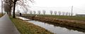 The Lieve Canal


References
[edit]- ^"Bevolking per gemeente op 1 januari 2022".Statbel.
- ^"Drie kleintjes zijn liever samen groot: in 2019 worden inwoners wakker in Lievegem".Nieuwsblad(in Dutch).Retrieved5 May2022.
- ^"Bevolking per statistische sector - Sector 44036".Statistics Belgium.Retrieved5 May2022.
- ^"Lovendegem, Zomergem en Waarschoot smelten samen tot Lievegem".Vlaamse Radio- en Televisieomroeporganisatie(in Dutch).Retrieved5 May2022.
- ^"Lievegem".Vlaanderen.be(in Dutch).Retrieved5 May2022.
External links
[edit] Media related toLievegemat Wikimedia Commons
- Official site
Belgian municipalityLievegem | |
|---|---|
| Deelgemeentes | |
| Aalst |  | |
|---|---|---|
| Dendermonde | ||
| Eeklo | ||
| Ghent | ||
| Oudenaarde | ||
| Sint-Niklaas | ||
| ||
| Authority control databases:Geographic |
|---|
ThisEast Flanderslocation article is astub.You can help Wikipedia byexpanding it. |