Loiret (river)
Appearance
| Loiret | |
|---|---|
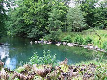
 The Loiret nearOlivet,south of Orléans | |
| Location | |
| Country | France |
| Physical characteristics | |
| Source | |
| • coordinates | 47°51′01″N1°56′14″E/ 47.8504°N 1.9372°E |
| Mouth | |
• location | Loire |
• coordinates | 47°51′52″N1°48′02″E/ 47.8644°N 1.8005°E |
| Length | 11.6 km (7.2 mi) |
| Basin features | |
| Progression | Loire→Atlantic Ocean |
TheLoiret(French pronunciation:[lwaʁɛ]) is a 11.6-kilometre (7.2 mi) longriverinFrance,alefttributary to theLoire.[1]Its waters come from infiltrations from the Loire.
Its course is completely within theLoiretdépartement,to which it gives its name.

The Loiret, south ofOrléans,with its picturesque formermills,is a popular destination for walking and boating trips. The source of the Loiret is a feature of theParc Floral de la Source(Le Bouillon), and its mouth inSaint-Hilaire-Saint-Mesmin,southwest of Orléans.
References
[edit] Media related toLoiret Riverat Wikimedia Commons


