Royal Borough of Kingston upon Thames
Royal Borough of Kingston upon Thames | |
|---|---|
 River Thamespassing throughKingston upon Thames | |
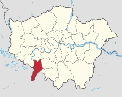
 Kingston upon Thames shown withinGreater London | |
| Sovereign state | United Kingdom |
| Constituent country | England |
| Region | London |
| Ceremonial county | Greater London |
| Created | 1 April 1965 |
| Admin HQ | Kingston upon Thames |
| Government | |
| • Type | London borough council |
| • Body | Kingston upon Thames London Borough Council |
| • London Assembly | Gareth Roberts(Liberal Democrats) AM forSouth West |
| •MPs | Sir Ed Davey(Liberal Democrat) Sarah Olney(Liberal Democrat) |
| Area | |
| • Total | 14.38 sq mi (37.25 km2) |
| • Rank | 267th(of 296) |
| Population (2022) | |
| • Total | 168,302 |
| • Rank | 122nd(of 296) |
| • Density | 12,000/sq mi (4,500/km2) |
| Time zone | UTC(GMT) |
| • Summer (DST) | UTC+1(BST) |
| Postcodes | |
| Area code | 020 |
| ONS code | 00AX |
| GSS code | E09000021 |
| Police | Metropolitan Police |
| Website | http:// kingston.gov.uk/ |
TheRoyal Borough of Kingston upon Thamesis aboroughin southwestLondon.The main town isKingston upon Thamesand it includesChessington,Malden Rushett,New Malden,SurbitonandTolworth.It is the oldest of the fourroyal boroughsin England. The others areWindsor and Maidenhead,the site ofWindsor Castle,and the London boroughs ofGreenwich,andKensington and Chelsea.The local authority isKingston upon Thames London Borough Council.
The neighbouring districts (clockwise from north) are the London boroughs ofRichmond upon Thames,Wandsworth,MertonandSutton,and theSurreydistricts ofEpsom and Ewell,Mole ValleyandElmbridge.
History[edit]
Kingston upon Thames, on the south bank of theRiver Thameshas existed for many hundreds of years. ManyRomanrelics have been found in the surrounding areas. A church has stood on the site ofAll Saints' Church,in the centre of Kingston, for more than a thousand years. An earlier church was sacked by theVikingsin 1009 AD. Kingston was the site of thecoronationsof sevenAnglo-Saxon monarchs:
- Edward the Elder,son ofAlfred the Great,900AD
- Athelstan,925AD
- Edmund I,939AD
- Eadred,946AD
- Eadwig,956AD
- Edward the Martyr,975AD
- Ethelred the Unready,979AD
TheCoronation Stone,on which they are said to have been crowned stands outside the local council offices, the Guildhall. A coin from the reign of each of those kings is set into the base of the stone.

Administrative history[edit]
The town of Kingston upon Thames was anancient borough,having been formally incorporated in 1441, with a long history prior to that as aroyal manordating back toSaxontimes.[1][2]The borough was reformed to become amunicipal boroughin 1836 under theMunicipal Corporations Act 1835,which standardised how most boroughs operated across the country.[3]Kingston was often described as aroyal borough,with its right to that title being formally confirmed in 1927.[4]
The old borough did not cover the wholeparishof Kingston upon Thames, and separate local government arrangements were later put in place for the outlying parts of the parish.Surbitonwas made animprovement commissioners districtin 1855,[5]andNew Maldenwas made alocal government districtin 1866.[6]
Such districts were reconstituted asurban districtsunder theLocal Government Act 1894.[7]New Malden was enlarged in 1895 to take in the neighbouring parishes ofCoombeandMalden,at which point the urban district was renamed The Maldens and Coombe. Surbiton was also enlarged in 1895, absorbing the parishes ofHookandTolworth,and again in 1933 when it absorbedChessington.Both urban districts were incorporated to become municipal boroughs in 1936, at which point The Maldens and Coombe was renamed Malden and Coombe.[8][9]
The modern borough was created in 1965 under theLondon Government Act 1963,covering the combined area of the former municipal boroughs ofKingston-upon-Thames,Malden and CoombeandSurbiton.The area was transferred fromSurreyto Greater London to become one of the 32 London Boroughs.[10]Kingston's royal borough status transferred to the enlarged borough.
Most of the borough continued to have Surrey postal addresses until postal counties were abolished in 1996. Districts mainly use the KTpostcode,except from the parts ofHamin the borough which use the TW code, and the Kingston Vale area in the north-east which has an SW15 postcode.
Districts in the borough[edit]
Areas in the borough include:
Governance[edit]

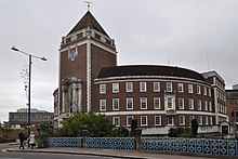
The local authority is Kingston Council, which is based atKingston upon Thames Guildhall.[11]
Greater London representation[edit]
Since 2000, for elections to theLondon Assembly,the borough forms part of theSouth Westconstituency.
UK Parliament[edit]
The borough includes the whole of theKingston and Surbiton Parliamentary Constituencyand part of theRichmond Park Constituencywith both constituencies being created in 1997. The previous constituencies re-arranged to form these two had been essentially Conservative.
In 1997 theLiberal Democratswon both seats.Jenny Tongetook Richmond Park constituency and in 2005Susan Kramerbecame its Liberal Democrat MP with a majority of 3,731 but she was beaten in the May 2010 election by ConservativeZac Goldsmithwith a majority of 4,091. Goldsmith retained his seat at the2015 general election,with a greatly increased majority of 23,015.[12]Goldsmith stood as an Independent candidate in theby-electionheld on 1 December 2016, but was defeated bySarah Olney,a Liberal Democrat, after the Conservative Party decided not to put forward its own candidate.[13]Goldsmith regained the seat for the Conservatives in the2017 general electionwith a significantly reduced majority of 45 votes.[14]Sarah Olney then regained the seat during the 2019 general election.[15]
In 1997Ed Daveyoverturned the previous Conservative majority of more than 10,000 in Kingston and Surbiton, to win by 56 votes after three recounts. He retained the seat in 2001 with a majority of 15,676 over the Conservative candidateDavid Shaw.In 2005 Davey's majority was 8,961, and in the May 2010 general election he again retained the seat with a slightly reduced majority, beating the Conservative candidateHelen Whately.In the2015 general election,Davey's seat was taken byConservativeJames Berry[16]with a majority of 2,834. Davey's was one of six Liberal Democrat losses in London and 49 overall as the party suffered its worst election results since its formation in 1988.[17]Davey regained the seat in the2017 general election.[18]
Demography[edit]

| Year | Pop. | ±% |
|---|---|---|
| 1801 | 4,612 | — |
| 1811 | 4,960 | +7.5% |
| 1821 | 6,050 | +22.0% |
| 1831 | 7,212 | +19.2% |
| 1841 | 9,587 | +32.9% |
| 1851 | 12,080 | +26.0% |
| 1861 | 19,863 | +64.4% |
| 1871 | 27,647 | +39.2% |
| 1881 | 35,430 | +28.2% |
| 1891 | 44,106 | +24.5% |
| 1901 | 54,956 | +24.6% |
| 1911 | 68,481 | +24.6% |
| 1921 | 79,468 | +16.0% |
| 1931 | 92,220 | +16.0% |
| 1941 | 115,055 | +24.8% |
| 1951 | 143,545 | +24.8% |
| 1961 | 142,448 | −0.8% |
| 1971 | 141,375 | −0.8% |
| 1981 | 131,230 | −7.2% |
| 1991 | 137,453 | +4.7% |
| 2001 | 147,295 | +7.2% |
| 2011 | 160,060 | +8.7% |
| Note:[19] | ||
Ethnicity[edit]
The following table shows the ethnic group of respondents in the 2001 and 2011 census in Kingston upon Thames.
| Ethnic Group | Year | |||||||||||
|---|---|---|---|---|---|---|---|---|---|---|---|---|
| 1971 estimations[20] | 1981 estimations[21] | 1991 census[22] | 2001 census[23] | 2011 census[24] | 2021 census[25] | |||||||
| Number | % | Number | % | Number | % | Number | % | Number | % | Number | % | |
| White:Total | – | 97.9% | 122,709 | 94.6% | 121,548 | 91.4% | 124,392 | 84.46% | 119,219 | 74.48% | 114,831 | 68.3% |
| White:British | – | – | – | – | – | – | 111,810 | 75.92% | 101,015 | 63.11% | 90,288 | 53.7% |
| White:Irish | – | – | – | – | – | – | 3,201 | 2.17% | 2,718 | 1.70% | 2,633 | 1.6% |
| White:Gypsy or Irish Traveller | – | – | – | – | – | – | – | – | 95 | 0.06% | 61 | 0.0% |
| White: Roma | – | – | – | – | – | – | – | – | – | – | 445 | 0.3% |
| White:Other | – | – | – | – | – | – | 9,381 | 6.37% | 15,391 | 9.62% | 21,404 | 12.7% |
| Asian or Asian British:Total | – | – | – | – | 8,447 | 6.35% | 13,492 | 9.16% | 26,152 | 16.34% | 29,938 | 17.9% |
| Asian or Asian British:Indian | – | – | – | – | 3,069 | 5,322 | 3.61% | 6,325 | 3.95% | 7,731 | 4.6% | |
| Asian or Asian British:Pakistani | – | – | – | – | 858 | 1,916 | 1.30% | 3,009 | 1.88% | 4,380 | 2.6% | |
| Asian or Asian British:Bangladeshi | – | – | – | – | 147 | 384 | 0.26% | 892 | 0.56% | 932 | 0.6% | |
| Asian or Asian British:Chinese | – | – | – | – | 1,089 | 2,026 | 1.38% | 2,883 | 1.80% | 4,127 | 2.5% | |
| Asian or Asian British: Other Asian | – | – | – | – | 3,284 | 3,844 | 2.61% | 13,043 | 8.15% | 12,768 | 7.6% | |
| Black or Black British:Total | – | – | – | – | 1,296 | 0.97% | 2,309 | 1.57% | 4,021 | 2.51% | 4,741 | 2.% |
| Black or Black British:African | – | – | – | – | 478 | 1,406 | 0.95% | 2,616 | 1.63% | 3,105 | 1.8% | |
| Black or Black British:Caribbean | – | – | – | – | 507 | 772 | 0.52% | 1,027 | 0.64% | 1,081 | 0.6% | |
| Black or Black British:Other Black | – | – | – | – | 311 | 131 | 0.09% | 378 | 0.24% | 555 | 0.3% | |
| Mixed or British Mixed:Total | – | – | – | – | – | – | 3,357 | 2.28% | 6,269 | 3.92% | 8,996 | 5.3% |
| Mixed: White and Black Caribbean | – | – | – | – | – | – | 591 | 0.40% | 1,238 | 0.77% | 1,564 | 0.9% |
| Mixed: White and Black African | – | – | – | – | – | – | 392 | 0.27% | 700 | 0.44% | 1,090 | 0.6% |
| Mixed: White and Asian | – | – | – | – | – | – | 1,398 | 0.95% | 2,500 | 1.56% | 3,540 | 2.1% |
| Mixed: Other Mixed | – | – | – | – | – | – | 976 | 0.66% | 1,831 | 1.14% | 2,802 | 1.7% |
| Other: Total | – | – | – | – | 1,705 | 1.3% | 3,723 | 2.53% | 4,399 | 2.75% | 9,559 | 5.7% |
| Other: Arab | – | – | – | – | – | – | – | – | 2,439 | 1.52% | 3,580 | 2.1% |
| Other: Any other ethnic group | – | – | – | – | 1,705 | 1.3% | 3,723 | 2.53% | 1,960 | 1.22% | 5,979 | 3.6% |
| Non-White: Total | – | 2.1% | 6,986 | 5.4% | 11,448 | 8.62% | 22,881 | 15.54% | 40,841 | 25.52% | 53,234 | 31.7% |
| Total | – | 100% | 129,695 | 100% | 132,996 | 100% | 147,273 | 100.00% | 160,060 | 100.00% | 168,065 | 100% |
Modern Kingston[edit]

Kingston benefits from one of the biggest and most visited shopping areas outside ofcentral London,with a varied selection of high street stores, and a large number of independent boutiques and retailers.
The most famous shop in Kingston[according to whom?]isBentalls,started byFrank Bentallin 1867 in Clarence Street, where it (or at least the completely rebuiltBentall Centre) stands.
Close to Kingston, and located between Kingston, Richmond and Roehampton, isRichmond Park,one of the oldest of London's royal parks.
The borough is home to the highest number ofSouth Koreansin Europe, in the town ofNew Malden.[citation needed]
Tourism in Kingston[edit]
Kingston has many attractions in and near it, ranging from nature and historical attractions totheme parks.
Some of the borough's attractions are:
- Chessington World of Adventures.Resort in the south of the borough. The closest railway station is Chessington South. Chessington is one of the UK's premier theme parks attracting thousands of visitors from all around the UK to its rides, aquarium and zoo.
- Thames Riverside. A walkway beside the Thames at Kingston andSurbiton,it has a variety of restaurants.
- Coronation Stone.Situated outside The Guildhall in Kingston, this ancient rock was the crowning point of some of England's early kings.
- Richmond Park.One of the world's largest urban parks, its Kingston Gate is situated within the borough's boundary.
- Kingston Town Centre. One of London's biggest shopping destinations, with hundreds of shops, cafes and restaurants, as well as a large entertainment complex, including anOdeon Cinemaand Tenpin Bowling. Also in the town centre is a historic market which has been running for hundreds of years.
- Rose Theatre.An 822-seat theatre in the centre of Kingston.
- Bentall Centre(a shopping centre). It is home to over 75 shops (including the Bentalls department store), restaurants and other services.
Economy[edit]
Kingston is the 3rd largest retail centre by employment, in London.
Sega Amusements International,responsible for the production of arcade games outside Japan, has its head office inChessington,Royal Borough of Kingston upon Thames.[26]Lidl relocated its UK Headquarters to Kingston in 2020.[27]
Industry[edit]
Sopwith Aviation Companyhad a factory in the Canbury Park area of Kingston, where the famousSopwith Camelwas produced duringWorld War I.TheHawker Hurricanewas designed in a site in Kingston town centre and built in the aviation factory near Ham now known as the Hawker Centre.
Education[edit]
Primary responsibility for education in the borough lies with the local education authority.
- The Kingston Academy(mixed), Richmond Road, Kingston upon Thames, KT2 5PE
- Chessington School(mixed), Garrison Lane, Chessington KT9 2JS
- Coombe Boys’ School,College Gardens, Blakes Lane, New Malden KT3 6NU
- Coombe Girls’ School,Clarence Avenue, New Malden KT3 3TU
- The Hollyfield School and Sixth Form Centre(mixed), Surbiton Hill Road, Surbiton KT6 4TU
- Holy Cross School(girls) (Roman Catholic), Sandal Road, New Malden KT3 5AR
- Richard Challoner School(boys) (Roman Catholic), Manor Drive North, New Malden KT3 5PE
- Southborough High School(boys), Hook Road, Surbiton KT6 5AS
- Tolworth Girls’ School and Sixth Form,Fullers Way North, Surbiton KT6 7LQ
- Tiffin Girls’ School,Richmond Road, Kingston upon Thames KT2 5PL
- Tiffin School (boys),Queen Elizabeth Road, Kingston upon Thames KT2 6RL
- Kingston Grammar School,70 London Rd, Kingston upon Thames KT2 6PY
- Surbiton High School,13 - 15 Surbiton Cres, Kingston upon Thames KT1 2JT
Further education[edit]
Higher education[edit]
Transport[edit]
Kingston has nineSouth Western Railwaystations andtwo centrally located bus stations,but noLondon Undergroundor otherTransport for Londonstations. In 2008, 64 bus routes served Kingston.
Railway[edit]
Coaching interests in Kingston opposed the plan of theLondon and Southampton Railwayto run its line to Southampton near Kingston. The line consequently avoided the town with a station opened in 1838 southwest of the town; it was later resited to the present site ofSurbiton station.
In 1863 a branch was built from Twickenham to a terminus in Kingston. That line was extended to the main line in 1869 to form theKingston Loop Line.
All rail services in the borough are operated by South Western Railway, who provide regular services to and fromLondon Waterloo.
Railway stations in the borough:
- Berrylands,London Zone 5
- Chessington North,London Zone 6
- Chessington South,London Zone 6
- Kingston,London Zone 6
- Malden Manor,London Zone 4
- New Malden,London Zone 4
- Norbiton,London Zone 5
- Surbiton,London Zone 6
- Tolworth,London Zone 5
Travel to work[edit]
In March 2011, the main forms of transport that residents used to travel to work were: driving a car or van, 26.1% of all residents aged 16–74; train, 7.1%; bus, minibus or coach, 7.1%; on foot, 6.9%; work mainly at or from home, 4.3%; bicycle, 2.8%; underground, metro, light rail, tram, 2.5%.[28]
Coat of arms[edit]
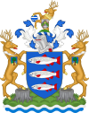
The Kingstoncoat of armsdisplays three salmon and its shield is almost identical to the coat of arms of theSwedishmunicipality ofLaholm.Both coats of arms can be traced back to the 16th century. The arms of theNorwegiantown ofMandalis also similar, but more recent.
In 1966 the newly createdLondon Boroughadded a setcrestsandsupporterstaken from the localities merged into it. The crest came from theMunicipal Borough of Malden and Coombe,with that borough's arms hung from the neck of the stag, and the supporters taken fromMunicipal Borough of Surbiton,with again its arms hanging from the stags' necks.[29]
International links[edit]
Although not officially 'twinned', The Royal Borough of Kingston has a partner city ofOldenburginGermanyandGwanak-gu,an administrative subdivision ofSeoul,inSouth Korea.Some road signs announce that Kingston is linked withDelftin theNetherlandsbut this official link has ended.[30]
Sport and leisure[edit]
The Borough of Kingston upon Thames has several football clubs in its area:
- Kingstonian,aNon-League footballclub who play atImperial Fields,Mitcham
- Corinthian Casuals,a non-League club who play at King George's Field, Tolworth
- Chessington & Hook United,a non-League club who play at Chalky Lane, Chessington
- Chelsea F.C. Women,who play at theKingsmeadow StadiuminWSL 1
References[edit]
- ^Report of the Commissioners appointed to inquire into the Municipal Corporations in England and Wales: Reports from places in any district.1834. p. 2892.Retrieved21 April2024.
- ^A History of the County of Surrey: Volume 3.London: Victoria County History. 1911. pp. 487–501.Retrieved21 April2024.
- ^Municipal Corporations Act.1835. p. 460.Retrieved21 April2024.
- ^"Royal Borough of Kingston-upon-Thames".The Times.27 October 1927. p. 14.
- ^"Surbiton Improvement Act 1855".legislation.gov.uk.The National Archives.Retrieved21 April2024.
- ^"No. 23195".The London Gazette.7 December 1866. p. 6834.
- ^"Local Government Act 1894",legislation.gov.uk,The National Archives,1894 c. 73,retrieved21 April2024
- ^"Malden and Coombe Urban District / Municipal Borough".A Vision of Britain through Time.GB Historical GIS / University of Portsmouth.Retrieved21 April2024.
- ^"Surbiton Urban District / Municipal Borough".A Vision of Britain through Time.GB Historical GIS / University of Portsmouth.Retrieved21 April2024.
- ^Youngs, Frederic (1979).Guide to the Local Administrative Units of England.Vol. I: Southern England. London:Royal Historical Society.ISBN0-901050-67-9.
- ^"Contact us".Kingston Council.Retrieved21 April2024.
- ^"Zac Goldsmith MP".Parliament.uk.UK Parliament.Retrieved14 July2017.
- ^"Zac Goldsmith quits as MP over 'doomed' Heathrow expansion decision".The Guardian.26 October 2016.Retrieved27 October2016.
- ^"GE2017 – Constituency results".Britain Elects (Google Docs).Retrieved10 June2017.
- ^"Richmond Park parliamentary constituency - Election 2019 - BBC News"– via bbc.
- ^"James Berry".Parliament.uk.UK Parliament.Retrieved14 July2017.
- ^"Kingston & Surbiton parliamentary constituency – Election 2017".BBC News.9 June 2017.Retrieved14 July2017.
- ^"Kingston & Surbiton".BBC News.Archivedfrom the original on 25 September 2018.Retrieved31 May2017.
- ^"Kingston: Total Population".A Vision of Britain Through Time.Great Britain Historical GIS Project.Retrieved6 September2011.
- ^"Migration and London's growth"(PDF).LSE.
- ^"Ethnic minorities in Britain: statistical information on the pattern of settlement".Commission for Racial Equality:Table 2.2. 1985.
- ^"1991 census – theme tables".NOMIS.Retrieved20 January2017.
- ^"KS006 – Ethnic group".NOMIS.Retrieved30 January2016.
- ^"Ethnic Group by measures".NOMIS.Retrieved8 January2016.
- ^"Ethnic group - Office for National Statistics".ons.gov.uk.Retrieved29 November2022.
- ^ContactsSega Amusements Europe
- ^Thames, The Royal Borough of Kingston upon."Lidl to move UK headquarters to Tolworth following £10m deal with Kingston Council".kingston.gov.uk.Retrieved6 December2020.
- ^"2011 Census: QS701EW Method of travel to work, local authorities in England and Wales".Office for National Statistics.Retrieved23 November2013.Percentages are of all residents aged 16–74 including those not in employment. Respondents could only pick one mode, specified as the journey’s longest part by distance.
- ^"Kingston-upon-Thames - Coat of arms (crest) of Kingston-upon-Thames".Heraldry of the World.Retrieved19 August2022.
- ^International Relations – European and International PartnershipsRoyal Borough of Kingston upon Thames


