Loulle
Appearance
Loulle | |
|---|---|
 The church in Loulle | |
| Coordinates:46°42′32″N5°52′56″E/ 46.7089°N 5.8822°E | |
| Country | France |
| Region | Bourgogne-Franche-Comté |
| Department | Jura |
| Arrondissement | Lons-le-Saunier |
| Canton | Champagnole |
| Government | |
| • Mayor(2020–2026) | Xavier Racle[1] |
| Area 1 | 10.90 km2(4.21 sq mi) |
| Population (2021)[2] | 171 |
| • Density | 16/km2(41/sq mi) |
| Time zone | UTC+01:00(CET) |
| • Summer (DST) | UTC+02:00(CEST) |
| INSEE/Postal code | 39301/39300 |
| Elevation | 610–776 m (2,001–2,546 ft) |
| 1French Land Register data, which excludes lakes, ponds, glaciers > 1 km2(0.386 sq mi or 247 acres) and river estuaries. | |
Loulle(French pronunciation:[lul]) is acommunein theJuradepartmentinregionofBourgogne-Franche-Comtéin easternFrance.[3]
Population
[edit]| Year | Pop. | ±% p.a. |
|---|---|---|
| 1968 | 114 | — |
| 1975 | 105 | −1.17% |
| 1982 | 160 | +6.20% |
| 1990 | 169 | +0.69% |
| 1999 | 177 | +0.52% |
| 2009 | 171 | −0.34% |
| 2014 | 172 | +0.12% |
| 2020 | 171 | −0.10% |
| Source: INSEE[4] | ||
Dinosaur Trails
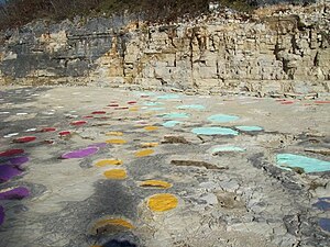
[edit]In 2004 a remarkable set of well-preserved dinosaur tracks were discovered in a quarry just outside Loulle. The tracks form a dense network of trails belonging mainly tosauropodsbut with other species represented. Many of the imprints have been painted by researchers from theUniversity of Lyonto indicate the tracks from individual animals. The caked muddy surface over which the dinosaurs walked is also well preserved in the rock.
The site is open to the public (no admission charged) and is on a sharp bend on the main road between Loulle and Nye.

See also
[edit]References
[edit]- ^"Répertoire national des élus: les maires".data.gouv.fr, Plateforme ouverte des données publiques françaises(in French). 2 December 2020.
- ^"Populations légales 2021"(in French).The National Institute of Statistics and Economic Studies.28 December 2023.
- ^INSEE commune file
- ^Population en historique depuis 1968,INSEE
Wikimedia Commons has media related toLoulle.


