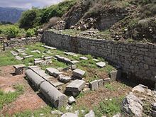
Lyktos


Lyktos(Greek:ΛύκτοςorΛύττος), was a city in ancientCrete.During theClassicalandRomanperiods, it was one of the major settlements on the island. Its ruins are located near the modern-day village of Lyttos in the municipality ofMinoa Pediada,Heraklion Regional Unit.
Lyktos in mythology
[edit]Lyktos appears in theHomericcatalogue.[1]According toHesiod,Theogony(477-484),Rheagave birth toZeusin Lyktos and hid him in a cave of Mount Aegaeon. The inhabitants of this ancientDoriccity called themselves colonists ofSparta,[2]and the worship ofApolloappears to have prevailed there.[3]
History
[edit]
The name "Lyktos" seems to originate in theBronze Age,appearing inLinear Btexts asru-ki-toand asrkt (ry-kꜣ-tı͗)in an Egyptian list of Aegean place names from theMortuary Temple of Amenhotep III.[4][5][6]
In 344 BC,PhalaecusthePhocisassisted theKnossiansagainst their neighbors the Lyktians, and took the city of Lyktos, from which he was driven out byArchidamus,king ofSparta.[7]The Lyktians, at a still later period, were engaged in frequent hostilities withKnossos,and succeeded in creating a formidable party in the island against that city. During theLyttian Warin 220 BC the Knossians, taking advantage of their absence on a distant expedition, surprised Lyktos, and utterly destroyed it. The citizens, on their return, abandoned it, and found refuge atLappa.Polybius,[8]on this occasion, bears testimony to the high character of the Lyktians, as compared with their countrymen. They afterwards recovered their city by the aid of theGortynians,who gave them a place calledDiatonium,which they had taken from the Knossians.[citation needed]
Lyktos was sacked by theRomangeneralMetellus,[9]but was existing in the time ofStrabo[10]at a distance of 80stadia(15 km) from theLibyan Sea.[11]The site still bears the name ofLytto,where ancient remains are now found.[12]
In the 16th century, Venetian manuscripts[13]describe the walls of the ancient city, with circular bastions, and other fortifications, as existing upon a lofty mountain, nearly in the centre of the island. Numerous vestiges of ancient structures, tombs, and broken marbles, are seen, as well as an immense arch of an aqueduct,[14]by which the water was carried across a deep valley by means of a large marble channel.
The harbor ofChersonesosserved as the port for Lyktos trade.
The town ofArsinoebelonged to Lyktos during theHellenistic period,according toStephanus of Byzantium,although its location is far from certain. Some scholars locate thisArsinoe (Crete)at the site of the older city ofRhithymna(although it is rather far from Lyktos). Others place it near the village ofMalia,atChersonesosabove, or elsewhere in the territory of Lyktos.[15]
The decoration of the coins issued at Lyktos is usually an eagle flying, with the inscription "ΛΥΤΤΙΩΝ" ( "of the Lyttians" ).[16]
Modern history
[edit]Before unearthing Knossos,Arthur Evansintended to excavate Lyktos but did not succeed in obtaining the necessary permits. As of 2022, only a small part of the site has been systematically excavated. A new five-year research program commenced in 2021, whose first year yielded significant findings the most important of which was a headless marble statue ofHadrian.[17]
References
[edit]- ^The Iliadii. 647, xvii. 611.
- ^AristotlePol.ii. 7.
- ^CallimachusHymn to Apollo33; comp. Müller,Dorians,vol. i. pp. 141, 227,trans.
- ^Elmar Edel;Manfred Görg (2005),Die Ortsnamenlisten im nördlichen Säulenhof des Totentempels Amenophis III(in German), Wiesbaden: Harrassowitz,ISBN3-4470-5219-8
- ^Cline, Eric; Stannish, Steven (2011)."Sailing the Great Green Sea? Amenhotep III's" Aegean List "from Kom el-Hetan, Once More".Journal of Ancient Egyptian Interconnections.3(2): 6–16.doi:10.2458/azu_jaei_v03i2_cline.
- ^Ventris, Michael;Chadwick, John (1973).Documents in Mycenaean Greek(Second ed.). Cambridge:Cambridge University Press.ISBN978-0-521-08558-8.
- ^Diodorusxvi. 62.
- ^iv. 53, 54.
- ^LivyEpit.xcix.;Florusiii. 7.
- ^x. p. 479.
- ^Strabo p. 476; comp.Stephanus of Byzantiums. v.;Scylaxp. 18;Plinyiv. 12; Aesych.s. v.Καρνησσόπολις;Hierocles.
- ^Robert Pashley,Trav.vol. i. p. 269.
- ^Mus. Class. Ant. vol. ii. p. 274.
- ^Kelly, A. 2018 A Roman Aqueduct through the Cretan Highlands - securing the water supply for elevated Lyttos. In G.A. Aristodemou and Th.P. Tassios (ed.) Great Waterworks in Roman Greece. Aqueducts and Monumental Fountain Structures: Function in Context. Archaeopress Roman Archaeology 35, 147-169
- ^Getzel M. Cohen,The Hellenistic Settlements in Europe, the Islands, and Asia Minor(Volume 17 of Hellenistic culture and society). University of California Press, 1995ISBN0520914082p132
- ^Eckhel,vol. ii. p.316; Töck,Kreta,vol. i. pp. 13, 408, vol. ii. pp. 431, 446, vol. iii. pp. 430, 465, 508.
- ^Ένας μήνας ανασκαφών έδωσε πληροφορίες για… 17 αιώνες!,Πατρίς onLine, 3 Αυγούστου 2021
 This article incorporates text from a publication now in thepublic domain:Smith, William,ed. (1854–1857).Dictionary of Greek and Roman Geography.London: John Murray.
{{cite encyclopedia}}:Missing or empty|title=(help)
External links
[edit]- "Lyktos Archaeological Project".24 July 2023.
