Lyubsha
- For the Ukrainian military facility, seeLyubsha (air base).

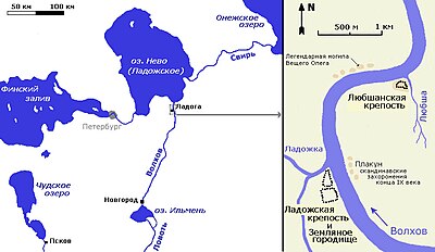
Lyubsha(Russian:Любша) is an archaeological site situated on the right bank of theVolkhov,about 1,500 metres downstream fromStaraya Ladoga.As was determined by the 1997 excavations, Lyubsha is the site of one of the oldestSlavicfort inRussia,[1]established in the first half of the 8th century, thus predating Ladoga. Its layout and dimensions closely resemble the contemporaneoushill fortsofGreat Moravia.
The fortress was destroyed by fire towards the end of the 9th century.[2]Constantine Zuckermanconnects its destruction with a conflict (Vadim's uprising) that marked the downfall of theRus' Khaganate.[3]The Norse name of Lyubsha is unknown.
Immediately north of Lyubsha lies the village of Gorchakovshchina, which used to be a trading post at the head of navigation on the Volkhov, near its ancient entry intoLake Ladoga.Dmitry Machinskyranks it, along with Ladoga andAlaborg,among the most important centres of the khaganate.[4]
References
[edit]- ^Articles about Lyubsha fortress
- ^Петренко В.П., Шитова Т.Е. Любшанское городище и средневековые поселения Северного Поволховья. // Средневековая Ладога. Leningrad, 1985.
- ^Zuckerman C.Deux étapes de la formation de l’ancien état russe,dansLes centres proto-urbains russes entre Scandinavie, Byzance et Orient. Actes du Colloque International tenu au Collège de France en octobre 1997,éd. M. Kazanski, A. Nersessian et C. Zuckerman (Réalités byzantines 7), Paris 2000, p. 95-120.
- ^Мачинский Д.А. О роли финноязычного населения бассейнов Волхова и Великой в сложении этносоциума "Русь" (VIII-XI вв.) // Современное финноугроведение. Опыт и проблемы. Leningrad, 1990.

