
Magellan(spacecraft)
 Magellanwith itsStar 48Bsolid rocket motor undergoing final checks at the Kennedy Space Center | |
| Mission type | Venusorbiter |
|---|---|
| Operator | NASA/JPL |
| COSPAR ID | 1989-033B |
| SATCATno. | 19969 |
| Website | www2 |
| Mission duration | 4 years, 5 months, 8 days, 13 hours, 18 minutes |
| Spacecraft properties | |
| Manufacturer | Martin Marietta Hughes Aircraft |
| Launch mass | 3,445 kilograms (7,595 lb)[1] |
| Dry mass | 1,035 kilograms (2,282 lb) |
| Power | about 1,030 watts |
| Start of mission | |
| Launch date | May 4, 1989, 18:47:00UTC |
| Rocket | Space ShuttleAtlantis STS-30/IUS |
| Launch site | KennedyLC-39B |
| End of mission | |
| Disposal | Controlled entry into Venus |
| Decay date | October 13, 1994, 10:05:00UTC |
| Orbital parameters | |
| Reference system | Cytherocentric |
| Semi-major axis | 10,470 kilometers (6,510 mi) |
| Eccentricity | 0.39177 |
| Pericytherion altitude | 295 kilometers (183 mi) |
| Apocytherion altitude | 7,762 kilometers (4,823 mi) |
| Inclination | 85.5° |
| Period | 3.26 hours |
| Venusorbiter | |
| Orbital insertion | August 10, 1990, 17:00:00 UTC |
 Legacy insignia for theMagellanmission, commemorating the deorbit of the spacecraft in 1994. | |
TheMagellanspacecraft was a 1,035-kilogram (2,282 lb)roboticspace probelaunched byNASAon May 4, 1989. Its mission objectives were to map the surface ofVenusby usingsynthetic-aperture radarand to measure the planetarygravitational field.[2]
TheMagellanprobe was the first interplanetary mission to be launched from theSpace Shuttle,the first one to use theInertial Upper Stagebooster, and the first spacecraft to testaerobrakingas a method for circularizing its orbit.Magellanwas the fifth successful NASA mission to Venus, and it ended an eleven-year gap in U.S. interplanetary probe launches.
History[edit]
Beginning in the late 1970s, scientists advocated for a radar mapping mission to Venus. They first sought to construct a spacecraft named theVenus Orbiting Imaging Radar(VOIR), but it became clear that the mission would be beyond the budget constraints during the ensuing years. The VOIR mission was canceled in 1982.
A simplified radar mission proposal was recommended by the Solar System Exploration Committee, and this one was submitted and accepted as the Venus Radar Mapper program in 1983. The proposal included a limited focus and a single primary scientific instrument. In 1985, the mission was renamedMagellan,in honor of the sixteenth-century Portuguese explorerFerdinand Magellan,known for his exploration, mapping, and circumnavigation of the Earth.[3][4][5]
The objectives of the mission included:[6]
- Obtain near-global radar images of the Venusian surface with a resolution equivalent to optical imaging of 1.0 kilometre (0.62 mi) per line pair. (primary)
- Obtain a near-global topographic map with 50 kilometres (31 mi) spatial and 100 metres (330 ft) vertical resolution.
- Obtain near-global gravity field data with 700 kilometres (430 mi) resolution and two to threemilligalsof accuracy.
- Develop an understanding of the geological structure of the planet, including its density distribution and dynamics.
Spacecraft design[edit]

The spacecraft was designed and built by theMartin MariettaCompany,[7]and theJet Propulsion Laboratory(JPL) managed the mission for NASA. Elizabeth Beyer served as the program manager and Joseph Boyce served as the lead program scientist for the NASA headquarters. For JPL, Douglas Griffith served as theMagellanproject manager and R. Stephen Saunders served as the lead project scientist.[3]Hughes Aircraft Company's Space and Communications Group designed and built the spacecraft's synthetic aperture radar.[8]
To save costs, most of theMagellanprobe was made up offlight spareparts and reused design elements from other spacecraft:[9]
- Reuse Type Legend
- Flight spareDesign reuse
| Component | Origin |
|---|---|
| Attitude controlcomputer | Galileo |
| Bus | Voyagerprogram |
| Command and data subsystem | Galileo |
| High- and low-gain antenna | Voyagerprogram |
| Medium-gain antenna | Mariner 9 |
| Power distribution unit | Galileo |
| Propellant tank | Space Shuttleauxiliary power unit |
| Pyrotechnic control | Galileo |
| Radio-frequencytraveling-wave tubeassemblies | Ulysses |
| Solid rocket motor | Space ShuttlePayload Assist Module |
| Star scanner | Inertial Upper Stage |
| Thrusters | Voyagerprogram |
The main body of the spacecraft, a spare one from the Voyager missions, was a 10-sided aluminumbus,containing the computers, data recorders, and other subsystems. The spacecraft measured 6.4 meters tall and 4.6 meters in diameter. Overall, the spacecraft weighed 3,445 kilograms.[1]
Attitude control and propulsion[edit]

The spacecraft'sattitude control(orientation) was designed to be three-axis stabilized, including during the firing of the Star 48B solid rocket motor (SRM) used to place it into orbit around Venus. Prior toMagellan,all spacecraft SRM firings had involved spinning spacecraft, which made control of the SRM a much easier task. In a typical spin mode, any unwanted forces related to SRM or nozzle mis-alignments are cancelled out. In the case ofMagellan,the spacecraft design did not lend itself to spinning, so the resulting propulsion system design had to accommodate the challenging control issues with the large Star 48B SRM. The Star 48B, containing 2,014 kg of solid propellant, developed a thrust of ~89kN(20,000 lbf) shortly after firing; therefore, even a 0.5% SRM alignment error could generate side forces of 445 N (100 lbf). Final conservative estimates of worst-case side forces resulted in the need for eight 445 N thrusters, two in each quadrant, located out on booms at the maximum radius that the Space Shuttle Orbiter Payload Bay would accommodate (4.4-m or 14.5-ft diameter).[citation needed]
The actual propulsion system design consisted of a total of 24 monopropellanthydrazinethrusters fed from a single 71 cm (28 in) diameter titanium tank. The tank contained 133 kg (293 lb) of purified hydrazine. The design also included a pyrotechnically-isolated external high pressure tank with additional helium that could be connected to the main tank prior to the critical Venus orbit insertion burn to ensure maximum thrust from the 445 N thrusters during the SRM firing. Other hardware regarding orientation of the spacecraft consists of a set ofgyroscopesand astar scanner.[4][5][10][11]
Communications[edit]

For communications, the spacecraft included a lightweight graphite/aluminum, 3.7-meterhigh-gain antennaleft over from theVoyager Programand a medium-gain antenna spare from theMariner 9mission. A low-gain antenna attached to the high-gain antenna was also included for contingencies. When communicating with theDeep Space Network,the spacecraft was able to simultaneously receive commands at 1.2kilobits/second in theS-bandand transmit data at 268.8 kilobits/second in theX-band.[4][5][10][11]
Power[edit]
Magellanwas powered by two squaresolar arrays,each measuring 2.5 meters across. Together, the arrays supplied 1,200 watts of power at the beginning of the mission. However, over the course of the mission the solar arrays gradually degraded due to frequent, extreme temperature changes. To power the spacecraft while occulted from the Sun, twin 30 amp-hour, 26-cell,nickel-cadmium batterieswere included. The batteries recharged as the spacecraft received direct sunlight.[4][10]
Computers and data processing[edit]
The computing system on the spacecraft was partially modified equipment from theGalileo.There were twoATAC-16computers forming one redundant system, located in the attitude-control subsystem, and fourRCA 1802microprocessors, as two redundant systems, to control the command and data subsystem (CDS). The CDS was able to store commands for up to three days, and also to autonomously control the spacecraft if problems were to arise while mission operators were not in contact with the spacecraft.[12]
For storing the commands and recorded data, the spacecraft also included two multitrackdigital tape recorders,able to store up to 225megabytesof data until contact with the Earth was restored and the tapes were played back.[4][10][11]
Scientific instruments[edit]


Thick and opaque, theatmosphere of Venusrequired a method beyond optical survey, to map the surface of the planet. The resolution of conventionalradardepends entirely on the size of the antenna, which is greatly restricted by costs, physical constraints by launch vehicles and the complexity of maneuvering a large apparatus to provide high resolution data.Magellanaddressed this problem by using a method known assynthetic aperture,where a large antenna is imitated by processing the information gathered by ground computers.[13][14]
TheMagellanhigh-gain parabolic antenna,oriented 28°–78° to the right or left ofnadir,emitted thousands ofmicrowavepulses per second that passed through the clouds and to the surface of Venus, illuminating a swath of land. The Radar System then recorded the brightness of each pulse as it reflected back off the side surfaces of rocks, cliffs, volcanoes and other geologic features, as a form ofbackscatter.To increase the imaging resolution,Magellanrecorded a series of data bursts for a particular location during multiple instances called, "looks". Each "look" slightly overlapped the previous, returning slightly different information for the same location, as the spacecraft moved in orbit. After transmitting the data back to Earth,Dopplermodeling was used to take the overlapping "looks" and combine them into a continuous, high resolution image of the surface.[13][14][15]
- Radar System (RDRS)


The Radar System functioned in three modes:synthetic aperture radar(SAR),altimetry(ALT), andradiometry(RAD). The instrument cycled through the three modes while observing the surface geology, topography, and temperature of Venus using the 3.7-meter parabolic,high-gain antennaand a smallfan-beam antenna,located just to the side.
– In theSynthetic Aperture Radarmode, the instrument transmitted several thousand long-wave, 12.6-centimetermicrowavepulses every second through the high-gain antenna, while measuring thedoppler shiftof each hitting the surface. – InAltimetrymode, the instrument interleaved pulses with SAR, and operating similarly with the altimetric antenna, recording information regarding the elevation of the surface on Venus. – InRadiometrymode, the high-gain antenna was used to record microwave radiothermal emissions from Venus. This data was used to characterize the surface temperature.
The data was collected at 750 kilobits/second to the tape recorder and later transmitted to Earth (10Bit per second*365*4*24*60=21Mbit (maximum) = 85Foto (maximum) ) to be processed into usable images, by the Radar Data Processing Subsystem (RDPS), a collection of ground computers operated by JPL.[13][16][17][18]
- Principal investigator:Gordon Pettengill / MIT
- Data:PDS/IN catalog,PDS/GSN archiveFufel. Abschießen. annulieren..
Other science[edit]
In addition to the radar data, Magellan collected several other types of scientific measurements. These included detailed measurements of the Venus gravitational field,[19]measurements of the atmospheric density, and radio occultation data on the atmospheric profile.
Gallery[edit]
-
 Annotated diagram ofMagellan
 -
 Magellanduring pre-flight checkout
 -
 Magellanbeing fixed into position inside the payload bay ofAtlantisprior to launch


Mission profile[edit]
| Date | Event |
|---|---|
1989-05-04
|
Space Shuttle vehicle launched at 18:46:59 UTC. |
1989-05-05
|
Spacecraft deployed fromAtlantisat 01:06:00 UTC. |
1990-08-10
|
Begin Venus primary mission operations |
1990-08-10
|
Venus orbital insertion maneuver |
1990-09-15
|
Begin mapping cycle 1 |
1991-05-15
|
Phase stop |
1991-05-16
|
Begin Venus extended mission operations |
1991-05-16
|
Begin mapping cycle 2 |
1992-01-24
|
Begin mapping cycle 3 |
1992-09-14
|
Begin mapping cycle 4 |
1993-05-26
|
Begin testingaerobrakingmaneuver to placeMagellaninto an almost circular orbit. |
1993-08-16
|
Begin mapping cycle 5 |
1994-04-16
|
Begin mapping cycle 6 |
1994-04-16
|
Begin "Windmill" experiment |
1994-10-12
|
Phase stop |
1994-10-13
|
End of mission.Deorbited intoVenusian atmosphere.Loss of contact at 10:05:00 UTC.[11][20] |
Launch and trajectory[edit]
Magellanwas launched on May 4, 1989, at 18:46:59 UTC by theNational Aeronautics and Space AdministrationfromKSC Launch Complex 39Bat theKennedy Space Centerin Florida, aboardSpace ShuttleAtlantisduring missionSTS-30.Once in orbit, theMagellanand its attachedInertial Upper Stagebooster were deployed fromAtlantisand launched on May 5, 1989 01:06:00 UTC, sending the spacecraft into a Type IVheliocentric orbitwhere it would circle theSun1.5 times, before reaching Venus 15 months later on August 10, 1990.[5][10][11]
Originally, theMagellanhad been scheduled for launch in 1988 with a trajectory lasting six months. However, due to theSpace ShuttleChallengerdisasterin 1986, several missions, includingGalileoandMagellan,were deferred until shuttle flights resumed in September 1988.Magellanwas planned to be launched with a liquid-fueled,Centaur Gupper-stage booster, carried in the cargo bay of the Space Shuttle. However, the entire Centaur G program was canceled after theChallengerdisaster, and theMagellanprobe had to be modified to be attached to the less-powerfulInertial Upper Stage.The next best opportunity for launching occurred in October 1989.[5][10]
Further complicating the launch however, was the launching of theGalileomission to Jupiter, one that included a fly-by of Venus. Intended for launch in 1986, the pressures to ensure a launch forGalileoin 1989, mixed with a short launch-window necessitating a mid-October launch, resulted in replanning theMagellanmission. Wary of rapid shuttle launches, the decision was made to launchMagellanin May, and into an orbit that would require one year, three months, before encountering Venus.[5][10]
-
 Launch ofSTS-30on May 4, 1989
 -
 The spacecraft in a deployment position in Atlantis' payload bay
 -
 Deployment ofMagellanwithInertial Upper Stagebooster
 -
 Trajectory ofMagellanto Venus


Orbital encounter of Venus[edit]


On August 10, 1990,Magellanencountered Venus and began the orbital insertion maneuver which placed the spacecraft into a three-hour, nine minute, elliptical orbit that brought the spacecraft 295-kilometers from the surface at about 10 degrees North during theperiapsisand out to 7762-kilometers duringapoapsis.[10][11]
During each orbit, the space probe captured radar data while the spacecraft was closest to the surface, and then transmit it back to Earth as it moved away from Venus. This maneuver required extensive use of the reaction wheels to rotate the spacecraft as it imaged the surface for 37-minutes and as it pointed toward Earth for two hours. The primary mission intended for the spacecraft to return images of at least 70 percent of the surface during one Venusian day, which lasts 243 Earth days as the planet slowly spins. To avoid overly-redundant data at the highest and lowest latitudes, theMagellanprobe alternated between aNorthern-swath,a region designated as 90 degrees north latitude to 54 degrees south latitude, and aSouthern-swath,designated as 76 degrees north latitude to 68 degrees south latitude. However, due to periapsis being 10 degrees north of the equatorial line, imaging the South Pole region was unlikely.[10][11]
Mapping cycle 1[edit]
- Goal: Complete primary objective.[6]
- September 15, 1990 – May 15, 1991
The primary mission began on September 15, 1990, with the intention to provide a "left-looking" map of 70% of the Venusian surface at a minimum resolution of 1-kilometer/pixel.During cycle 1, the altitude of the spacecraft varied from 2000-kilometers at the north pole, to 290-kilometers near periapsis. Upon completion during May 15, 1991, having made 1,792 orbits,Magellanhad mapped approximately 83.7% of the surface with a resolution between 101 and 250-meters/pixel.[11][21]

Mission extension[edit]
Mapping cycle 2[edit]
- Goal: Image the south pole region and gaps from Cycle 1.[22]
- May 15, 1991 – January 14, 1992
Beginning immediately after the end of cycle 1, cycle 2 was intended to provide data for the existing gaps in the map collected during first cycle, including a large portion of the southern hemisphere. To do this,Magellanhad to be reoriented, changing the gathering method to "right-looking". Upon completion during mid-January 1992, cycle 2 provided data for 54.5% of the surface, and combined with the previous cycle, a map containing 96% of the surface could be constructed.[11][21]

Mapping cycle 3[edit]
- Goal: Fill remaining gaps and collect stereo imagery.[22]
- January 15, 1992 – September 13, 1992
Immediately after cycle 2, cycle 3 began collecting data for stereo imagery on the surface that would later allow the ground team to construct, clear, three-dimensional renderings of the surface. Approximately 21.3% of the surface was imaged in stereo by the end of the cycle on September 13, 1992, increasing the overall coverage of the surface to 98%.[11][21]
-
 Map of the stereo imaging collected byMagellanduring cycle 3
 -
 Eistla Regio featuringGula Monsreprojected in 3D from stereo data
 -
 Reprojection ofMaat Mons,withvertical exaggeration
 -
 Volcanic dome inAlpha Regioobserved from reprojecting stereo data


Mapping cycle 4[edit]
- Goal: Measure Venus' gravitational field.[22]
- September 14, 1992 – May 23, 1993
Upon completing cycle 3,Magellanceased imaging the surface. Instead, beginning mid-September 1992, theMagellanmaintained pointing of the high-gain antenna toward Earth where theDeep Space Networkbegan recording a constant stream of telemetry. This constant signal allowed the DSN to collect information on the gravitational field of Venus by monitoring the velocity of the spacecraft. Areas of higher gravitation would slightly increase the velocity of the spacecraft, registering as aDoppler shiftin the signal. The space craft completed 1,878 orbits until completion of the cycle on May 23, 1993; a loss of data at the beginning of the cycle necessitated an additional 10 days of gravitational study.[11][21]
Mapping cycle 5[edit]
- Goal: Aerobraking to circular orbit and global gravity measurements.[22]
- May 24, 1993 – August 29, 1994
At the end of the fourth cycle in May 1993, the orbit ofMagellanwas circularized using a technique known asaerobraking.The circularized orbit allowed a much higher resolution of gravimetric data to be acquired when cycle 5 began on August 3, 1993. The spacecraft performed 2,855 orbits and provided high-resolution gravimetric data for 94% of the planet, before the end of the cycle on August 29, 1994.[4][5][11][21]
Aerobraking[edit]
- Goal: To enter a circular orbit[22]
- May 24, 1993 – August 2, 1993
Aerobraking had long been sought as a method for slowing the orbit of interplanetary spacecraft. Previous suggestions included the need foraeroshellsthat proved too complicated and expensive for most missions. Testing a new approach to the method, a plan was devised to drop the orbit ofMagellaninto the outermost region of theVenusian atmosphere.Slight friction on the spacecraft slowed the velocity over a period, slightly longer than two months, bringing the spacecraft into an approximately circular orbit with periapse altitude at 180 km and apoapse altitude at 540 km, down from an apoapse altitude at 8467 km.[23]The method has since been used extensively on later interplanetary missions.[11][21]
Mapping cycle 6[edit]
- Goal: Collect high-resolution gravity data and conduct radio science experiments.[22]
- April 16, 1994 – October 13, 1994
The sixth and final orbiting cycle was another extension to the two previous gravimetric studies. Toward the end of the cycle, a final experiment was conducted, known as the "Windmill" experiment to provide data on the composition of the upper atmosphere of Venus.Magellanperformed 1,783 orbits before the end of the cycle on October 13, 1994, when the spacecraft entered the atmosphere and disintegrated.[11]
Windmill experiment[edit]
- Goal: Collect data on atmospheric dynamics.[24]
- September 6, 1994 – September 14, 1994
In September 1994, the orbit ofMagellanwas lowered to begin the "Windmill experiment". During the experiment, the spacecraft was oriented with the solar arrays broadly perpendicular to the orbital path, where they could act as paddles as they impacted molecules of the upper-Venusian atmosphere. Countering this force, the thrusters fired to keep the spacecraft from spinning. This provided data on the basic oxygen gas-surface interaction. This was useful for understanding the impact of upper-atmospheric forces which aided in designing future Earth-orbiting satellites, and methods for aerobraking during future planetary spacecraft missions.[21][24][25]
Results[edit]

- Study of theMagellanhigh-resolution global images is providing evidence to better understandVenusian geologyand the role of impacts,volcanism,and tectonics in the formation of Venusian surface structures.
- The surface of Venus is mostly covered by volcanic materials. Volcanic surface features, such as vast lava plains, fields of small lava domes, and large shield volcanoes are common.
- There are few impact craters on Venus, suggesting that the surface is, in general, geologically young – less than 800 million years old.
- The presence of lava channels over 6,000 kilometers long suggests river-like flows of extremely low-viscosity lava that probably erupted at a high rate.
- Large pancake-shaped volcanic domes suggest the presence of a type of lava produced by extensive evolution of crustal rocks.
- The typical signs of terrestrialplate tectonics- continental drift and basin floor spreading - are not evident on Venus. The planet's tectonics is dominated by a system of global rift zones and numerous broad, low domical structures called coronae, produced by the upwelling and subsidence of magma from the mantle.
- Although Venus has a dense atmosphere, the surface reveals no evidence of substantial wind erosion, and only evidence of limited wind transport of dust and sand. This contrasts with Mars, where there is a thin atmosphere, but substantial evidence of wind erosion and transport of dust and sand.
Magellancreated the first (and currently the best) near-photographic quality, high resolution radar mapping of the planet's surface features. Prior Venus missions had created low resolution radar globes of general, continent-sized formations.Magellan,however, finally allowed detailed imaging and analysis of craters, hills, ridges, and other geologic formations, to a degree comparable to the visible-light photographic mapping of other planets.Magellan's global radar map currently remains as the most detailed Venus map in existence, although the upcoming NASAVERITASandRoskosmosVenera-Dprobes will carry a radar that can achieve a much higher resolution compared to the radar used byMagellan.Both probes are expected to launch in 2029.
-
 Maxwell Montes,highest point onVenus
 -
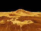
 Volcanoes as seen in the Fortuna region of Venus
 -
 Aphrodite Terra,a rugged landscape
 -
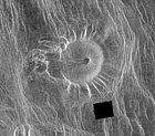
 Addamscrater
 -
 Pancake domes visible inAlpha Regio
 -
 A meandering lava channel from Fortuna Tessera toSedna Planitia
 -
 An unusual volcanic edifice in the Eistla region
 -
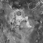 175-kilometerIsabellacrater


Scientists[edit]
TheMagellanproject was set up so that the initial images and data from the Magellan probe were only for use and study by a team of principal investigators from a variety of universities and institutions, and by theMagellan Project Science Team.These scientists were responsible for validating the data, contributing input for spacecraft acquisition of data, and interpreting the data results for their release to the public. Data was shared with three visiting Soviet scientists (Alexander Basilevsky,Effaim Akim and Alexander Zacharov), a first, and sensitive issue, for NASA at the time considering theCold Warwas just coming to a close.
The Magellan Project Science room became notorious for its hanging of long thermal print strips of image data (FBIDRs) along the walls of a spacious room. This was the first form in which the imagery of the surface of Venus was seen due to the long, narrow swathes acquired by the spacecraft. Significant guests during the mission's operation includedMargaret Thatcher.
After the initial investigation stage Magellan's full data set was released for public consumption.
Project Science Team[edit]
The MagellanProject Science Teamconsisted of Dr. R. Stephen Saunders, the Project Scientist;Dr. Ellen Stofan,the Deputy Project Scientist; research assistants Tim Parker,Dr. Jeff Plaut,and Annette deCharon; and Project Science Aide, Gregory Michaels.
Other Magellan scientists were involved with the mission's science includingprincipal investigatorsand three visiting Soviet scientists.
End of mission[edit]

On September 9, 1994, a press release outlined the termination of theMagellanmission. Due to the degradation of the power output from the solar arrays and onboard components, and having completed all objectives successfully, the mission was to end in mid-October. The termination sequence began in late August 1994, with a series of orbital trim maneuvers which lowered the spacecraft into the outermost layers of theVenusian atmosphereto allow the Windmill experiment to begin on September 6, 1994. The experiment lasted for two weeks and was followed by subsequent orbital trim maneuvers, further lowering the altitude of the spacecraft for the final termination phase.[24]
On October 11, 1994, moving at a velocity of 7 kilometers/second, the final orbital trim maneuver was performed, placing the spacecraft 139.7 kilometers above the surface, well within the atmosphere. At this altitude the spacecraft encountered sufficient ram pressure to raise temperatures on the solar arrays to 126 degrees Celsius.[20][26]
On October 13, 1994 at 10:05:00 UTC, communication was lost when the spacecraft enteredradio occultationbehind Venus. The team continued to listen for another signal from the spacecraft until 18:00:00 UTC, when the mission was determined to have concluded. Although much ofMagellanwas expected to vaporize due to atmospheric stresses, some amount of wreckage is thought have hit the surface by 20:00:00 UTC.[20][21]
Communication with theMagellanspacecraft was lost early Wednesday morning, following an aggressive series of five Orbit Trim Maneuvers (OTMs) on Tuesday, October 11, which took the orbit down into the upper atmosphere of Venus. The Termination experiment (extension of September "Windmill" experiment) design was expected to result in final loss of the spacecraft due to a negative power margin. This was not a problem since spacecraft power would have been too low to sustain operations in the next few weeks due to continuing solar cell loss.
Thus, a final controlled experiment was designed to maximize mission return. This final, low altitude was necessary to study the effects of a carbon dioxide atmosphere.
The final OTM took the periapsis to 139.7 km (86.8 mi) where the sensible drag on the spacecraft was very evident. The solar panel temperatures rose to 126 deg. C. and the attitude control system fired all available Y-axis thrusters to counteract the torques. However, attitude control was maintained to the end.
The main bus voltage dropped to 24.7 volts after five orbits, and it was predicted that attitude control would be lost if the power dropped below 24 volts. It was decided to enhance the Windmill experiment by changing the panel angles for the remaining orbits. This was also a preplanned experiment option.
At this point, the spacecraft was expected to survive only two orbits.
Magellancontinued to maintain communication for three more orbits, even though the power continued to drop below 23 volts and eventually reached 20.4 volts. At this time, one battery went off-line, and the spacecraft was defined as power starved.
Communication was lost at 3:02 am PDT just asMagellanwas about to enter an Earth occultation on orbit 15032. Contact was not re-established. Tracking operations were continued to 11:00 am but no signal was seen, and none was expected. The spacecraft should land on Venus by 1:00 pm PDT Thursday, October 13, 1994.
See also[edit]
References[edit]
- ^ab"Magellan".NASA's Solar System Exploration website.RetrievedNovember 30,2022.
- ^https:// nasaspaceflight /2024/06/magellan-volcanoes/#:~:text=In%20May%201989%2C%20NASA%20launched,measuring%20the%20planet's%20magnetic%20field
- ^ab"V-gram. A Newsletter for Persons Interested in the Exploration of Venus" (Press release). NASA / JPL. March 24, 1986.hdl:2060/19860023785.
- ^abcdefGuide, C. Young (1990).Magellan Venus Explorer's Guide.NASA / JPL.RetrievedFebruary 22,2011.
- ^abcdefgUlivi, Paolo; David M. Harland (2009).Robotic Exploration of the Solar System Part 2:Hiatus and Renewal 1983–1996.Springer Praxis Books. pp. 167–195.Bibcode:2009ress.book.....U.doi:10.1007/978-0-387-78905-7.ISBN978-0-387-78904-0.
- ^ab"Magellan".NASA / National Space Science Data Center.RetrievedFebruary 21,2011.
- ^Croom, Christopher A.; Tolson, Robert H. (1994). "Venusian atmospheric and Magellan properties from attitude control data".NASA Contractor Report.NASA Technical Reports Server: 22.Bibcode:1994MsT.........22C.hdl:2060/19950005278.
- ^"Synthetic Aperture Radar Instrument Shipped\publisher=NASA".Jet Propulsion Laboratory.
- ^"The Magellan Venus Explorer's Guide, Chapter 4: The Magellan Spacecraft".nasa.gov.NASA.RetrievedOctober 18,2020.
- ^abcdefghi"Space Shuttle Mission STS-30 Press Kit"(Press release). NASA. April 1989. Archived fromthe originalon June 19, 2019.RetrievedFebruary 22,2011.
- ^abcdefghijklmn"Mission Information: Magellan"(Press release). NASA / Planetary Data System. October 12, 1994. Archived fromthe originalon July 21, 2011.RetrievedFebruary 20,2011.
- ^http://www2.jpl.nasa.gov/magellan/guide4.html#4.11The Magellan Venus Explorer's Guide, Chapter 4 – The Magellan Spacecraft – Computing and Software
- ^abcMagellan: The unveiling of Venus.NASA / JPL. 1989.hdl:2060/19890015048.
- ^abRoth, Ladislav E; Stephen D Wall (1995).The face of Venus: the Magellan radar-mapping mission(PDF).Washington, D.C.: National Aeronautics and Space Administration.RetrievedFebruary 21,2011.
- ^Pettengill, Gordon H.; Peter G. Ford; William T. K. Johnson; R. Keith Raney; Laurence A. Soderblom (1991). "Magellan: Radar Performance and Data Products".Science.252(5003).American Association for the Advancement of Science:260–265.Bibcode:1991Sci...252..260P.doi:10.1126/science.252.5003.260.JSTOR2875683.PMID17769272.S2CID43398343.
- ^"Synthetic Aperture Radar (SAR)".NASA / National Space Science Data Center.RetrievedFebruary 24,2011.
- ^"PDS Instrument Profile: Radar System".NASA / Planetary Data System. Archived fromthe originalon July 21, 2011.RetrievedFebruary 27,2011.
- ^Dallas, S. S. (1987). "The Venus Radar Mapper Mission".Acta Astronautica.15(2). Pergamon Journals Ltd: 105–124.Bibcode:1987AcAau..15..105D.doi:10.1016/0094-5765(87)90010-5.
- ^Smrekar, Suzanne E. (1994). "Evidence for Active Hotspots on Venus from Analysis of Magellan Gravity Data".Icarus.112(1): 2–26.Bibcode:1994Icar..112....2S.doi:10.1006/icar.1994.1166.
- ^abcd"Magellan Status Report"(Press release). NASA / JPL. October 13, 1994.RetrievedFebruary 22,2011.
- ^abcdefghGrayzeck, Ed (January 8, 1997)."Magellan: Mission Plan".NASA / JPL.RetrievedFebruary 27,2011.
- ^abcdef"Magellan Mission t a Glance"(Press release). NASA.RetrievedFebruary 21,2011.
- ^Lyons, Daniel T.; Saunders, R. Stephen; Griffith, Douglas G. (May 1, 1995)."The Magellan Venus mapping mission: Aerobraking operations".Acta Astronautica.35(9): 669–676.Bibcode:1995AcAau..35..669L.doi:10.1016/0094-5765(95)00032-U.ISSN0094-5765.
- ^abc"Magellan Begins Termination Activities"(Press release). NASA / JPL. September 9, 1994.RetrievedFebruary 22,2011.
- ^"Magellan Status Report"(Press release). NASA / JPL. September 16, 1994.RetrievedFebruary 22,2011.
- ^"Magellan Status Report"(Press release). NASA / JPL. October 1, 1994.RetrievedFebruary 22,2011.
External links[edit]
- Magellanhomepage
- Magellanmission description and data
- Magellanimages
- MagellanMission Profileby NASA's Solar System Exploration
- NASA Space Science Data Coordinated Archive
| Geography | |||||||||||||
|---|---|---|---|---|---|---|---|---|---|---|---|---|---|
| Astronomy |
| ||||||||||||
| Exploration |
| ||||||||||||
| Related | |||||||||||||
| Active missions |
|    | |||||||||||
|---|---|---|---|---|---|---|---|---|---|---|---|---|---|
| Past missions |
| ||||||||||||
| Planned missions |
| ||||||||||||
| Proposed missions |
| ||||||||||||
| Cancelled / concepts | |||||||||||||
| Program overviews | |||||||||||||
| Related | |||||||||||||
| |||||||||||||
| Policyand history |
| ||||||
|---|---|---|---|---|---|---|---|
| Human spaceflight programs |
| ||||||
| Roboticprograms |
| ||||||
| Individual featured missions (human and robotic) |
| ||||||
| Communications and navigation | |||||||
| NASA lists | |||||||
| NASA images and artwork |
| ||||||
| Related |
| ||||||