
Makira
 Makira and nearby islands | |
 Location of Makira in Solomon Islands | |
| Geography | |
|---|---|
| Location | Solomon Islands |
| Coordinates | 10°33′04″S161°49′41″E/ 10.55111°S 161.82806°E |
| Archipelago | Solomon Islands (archipelago) |
| Area | 3,190 km2(1,230 sq mi) |
| Highest elevation | 4,101 ft (1250 m) |
| Highest point | Unnamed Point |
| Administration | |
| Province | Makira-Ulawa Province |
| Largest settlement | Kirakira |
| Demographics | |
| Population | 55,126 (2020) |
The island ofMakira(previously known asSan Cristóbal) is the largest island ofMakira-Ulawa ProvinceinSolomon Islands.It is third most populous of the Solomon Islands afterMalaitaandGuadalcanal,with a population of 55,126 as of 2020. The island is located east ofGuadalcanaland south ofMalaita.The largest and capital city isKirakira.
History
[edit]The first recorded sighting by Europeans of Makira was by the Spanish expedition ofÁlvaro de Mendañain June 1568. More precisely the sighting and also landing in San Cristobal was due to a local voyage that set out fromGuadalcanalin a small boat, in the accounts thebrigantineSantiago,commanded byAlférezHernando Enriquezand havingHernán Gallegoas pilot. They charted it asSan Cristóbal.[1][2]
Education
[edit]TheStuyvenberg Rural Training Centreis a ruralboardingcentre ofvocational educationbythe Society of Mary,located on the north coast of eastern Makira.[3]
Environment
[edit]A 182,550 ha tract of largely forested land encompassing the eastern part of the island has been identified byBirdLife Internationalas anImportant Bird Area(IBA) because it supports populations of severalthreatenedorendemicbird species. The site extends from the rocky cliffs of the coast to the island's central Bauro Highlands, including the catchments of the Warihito and Raro Rivers, reaching an altitude of 1,200 m, and consisting largely oftropical rainforest.The landscape is rugged, with steep-sided valleys, many streams and waterfalls, and small perched floodplains. Potential threats to the environment arelogging,invasive speciesand humanpopulation growth.[4]
Birds
[edit]Significant birds includeMelanesian scrubfowl,yellow-legged pigeons,crested cuckoo-doves,red-knobbedandchestnut-bellied imperial pigeons,white-headed fruit doves,Makira boobooks,pied goshawks,Sanford's sea eagles,San Cristobal dwarf kingfishers,Meek'sandduchess lorikeets,yellow-bibbed lories,green pygmy-parrots,Makira honeyeaters,sooty myzomelas,long-tailed trillers,dusky fantails,Makira flycatchers,white-collaredandMakira monarchs,island leaf-warblers,shade bush warblers,grey-throated white-eyes,Makira starlings,Makira thrushesandmottled flowerpeckers.TheMakira woodhen,or moorhen, has not been seen since 1953; thethick-billed ground dovehas not been recorded since 1927 and is presumed extinct.[4]
Other biota
[edit]Five species of restricted-rangebatshave been recorded, as well as a possibly new species of giant rat (Solomys). There are two species of endemic fig (Ficus).[4]
Notable people
[edit]- Doreen Kuper- former Honorary Consul to New Zealand
- John Saunana- novelist, poet, and politician
Gallery
[edit]-
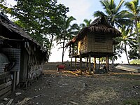 Some of the local houses next to the beach atKirakira
 -
 A Kirakira beach at sunset


References
[edit]- ^Sharp, AndrewThe discovery of the Pacific IslandsOxford, 1960, pp.46,47.
- ^Brand, Donald D.The Pacific Basin: A History of its Geographical ExplorationsThe American Geographical Society, New York, 1967, p.133.
- ^SOLOMON ISLANDS. Study to Support the Development of a National Skills Training Plan(Report). Washington: East Asia and Pacific Region. Human Development Sector Unit. The World Bank. March 2007. Report No. 39317-SB.
- ^abc"East Makira".BirdLife Data Zone.BirdLife International.Retrieved6 October2020.
External links
[edit] Media related toMakiraat Wikimedia Commons