
Malin Head

Malin Head(Irish:Cionn Mhálanna)[1]is themost northerly pointof mainlandIreland,located in thetownlandof Ardmalin[2]on theInishowenpeninsula inCounty Donegal.The head's northernmost point is called Dunalderagh at latitude 55.38ºN.[3]It is about 16 kilometres (10 mi) north of the village ofMalin.The island ofInishtrahullis further north, about 10 km (6 mi) northeast of the headland. Malin Head gives its name to the Malinsea area.There is a weather station on the head, which is one of22 such stationswhose reports are broadcast as part of theBBC Shipping Forecast.A tower built in 1805 is on Altnadarrow, also known locally as the Tower Hill.[4]
Ptolemy'sGeography(2nd century AD) described a point called Βορειον (Boreion,"the northern" ) which probably referred to Malin Head.[5]

Locality
[edit]To the northeastInistrahull Islandcan be seen. The firstlighthouseon the island was put into operation in 1813, and the light flashes every 30 seconds.
Below Altnadarrow to the east lies Ballyhillion beach, a unique raised beach system of international scientific importance.[6]The very distinct shorelines show the changing relationship between the sea and the land from the time the glaciers began to melt, some 15,000 years ago. At that timeCounty Donegalwas depressed by the weight of an immense ice sheet, so the level of the sea, relative to today's shore, was up to 80 feet higher than today.
Scenes fromStar Wars: The Last Jediwere filmed in Malin Head.[7]

Weather station
[edit]Weather reports commenced in Malin Head in 1885. In 1955 a new Meteorological station was built beside the coastguard station byMet Éireann.Hourly data points, which include sunshine, wind, rain etc, are recorded here.[8]
Climate
[edit]Malin Head has a temperateoceanic climate(Köppenclass Cfb). As a result of its exposed coastal location, high winds and storms are a notable presence for much of the year. Summers are typically mild bordering on cool, while winters have cool days and crisp nights.
| Climate data for Malin Head WMO ID:03980; coordinates55°22′19″N7°20′22″W/ 55.37182°N 7.33944°W;elevation: 22 m (72 ft); 1981–2010 normals, extremes 1885–present | |||||||||||||
|---|---|---|---|---|---|---|---|---|---|---|---|---|---|
| Month | Jan | Feb | Mar | Apr | May | Jun | Jul | Aug | Sep | Oct | Nov | Dec | Year |
| Record high °C (°F) | 14.4 (57.9) |
15.0 (59.0) |
19.0 (66.2) |
20.7 (69.3) |
25.1 (77.2) |
27.2 (81.0) |
27.0 (80.6) |
27.1 (80.8) |
28.9 (84.0) |
22.8 (73.0) |
17.6 (63.7) |
16.8 (62.2) |
28.9 (84.0) |
| Mean daily maximum °C (°F) | 8.1 (46.6) |
8.1 (46.6) |
9.3 (48.7) |
10.8 (51.4) |
13.1 (55.6) |
15.1 (59.2) |
16.8 (62.2) |
17.0 (62.6) |
15.6 (60.1) |
13.0 (55.4) |
10.4 (50.7) |
8.6 (47.5) |
12.2 (54.0) |
| Daily mean °C (°F) | 5.9 (42.6) |
5.8 (42.4) |
6.9 (44.4) |
8.3 (46.9) |
10.5 (50.9) |
12.7 (54.9) |
14.5 (58.1) |
14.7 (58.5) |
13.3 (55.9) |
10.8 (51.4) |
8.2 (46.8) |
6.4 (43.5) |
9.8 (49.6) |
| Mean daily minimum °C (°F) | 3.6 (38.5) |
3.5 (38.3) |
4.4 (39.9) |
5.8 (42.4) |
7.8 (46.0) |
10.3 (50.5) |
12.1 (53.8) |
12.3 (54.1) |
10.9 (51.6) |
8.5 (47.3) |
6.1 (43.0) |
4.2 (39.6) |
7.5 (45.5) |
| Record low °C (°F) | −6.2 (20.8) |
−6.7 (19.9) |
−5.0 (23.0) |
−3.9 (25.0) |
−0.6 (30.9) |
2.6 (36.7) |
5.6 (42.1) |
4.8 (40.6) |
2.0 (35.6) |
0.0 (32.0) |
−2.6 (27.3) |
−5.5 (22.1) |
−6.7 (19.9) |
| Averageprecipitationmm (inches) | 117.4 (4.62) |
84.8 (3.34) |
85.9 (3.38) |
63.1 (2.48) |
56.9 (2.24) |
69.1 (2.72) |
76.8 (3.02) |
93.2 (3.67) |
91.8 (3.61) |
118.4 (4.66) |
104.5 (4.11) |
114.2 (4.50) |
1,076 (42.36) |
| Average precipitation days(≥ 1 mm) | 18 | 13 | 15 | 12 | 11 | 11 | 14 | 14 | 14 | 17 | 17 | 16 | 172 |
| Average snowy days | 5.1 | 5.2 | 3.4 | 1.6 | 0.1 | 0.0 | 0.0 | 0.0 | 0.0 | 0.0 | 1.1 | 3.8 | 20.4 |
| Averagerelative humidity(%)(at 15:00LST) | 80.8 | 77.0 | 77.1 | 75.7 | 75.7 | 78.7 | 80.6 | 79.8 | 77.5 | 77.6 | 79.7 | 81.3 | 78.5 |
| Mean monthlysunshine hours | 37.2 | 65.0 | 93.0 | 153.0 | 201.5 | 165.0 | 142.6 | 136.4 | 111.0 | 80.6 | 45.0 | 34.1 | 1,264.4 |
| Source 1:Met Éireann[9][10][11] | |||||||||||||
| Source 2:[12] | |||||||||||||
Wartime use
[edit]
A military watchtower was built on Altnadarrow in 1805, during theNapoleonic Wars.Around 1902, a signal station used by the Marconi Company was built close to the old Napoleonic watchtower. Both of these buildings still stand.
DuringThe Emergency(World War II), theGovernment of Irelandallowed theBritish Governmentto site tworadio direction finderson Malin Head. Thistop-secretoperation was mentioned inThe Cranborne Report.The RDF equipment was used by Allied naval and air forces to monitorU-boatand aerial activity in theNorth Atlantic.A detailed history of radio at Malin Head,Marconi Wireless Radio Station: Malin Head from 1902was published in 2014.[13]
To the north of Altnadarrow and just before Dúnalderagh, a ground marker reading '80 EIRE' can be seen in large letters that were formed from placing stones together to form the letters. This was to signify to overflying planes that they were crossing Irish territory and that Ireland was neutral.[14]
Ornithology
[edit]Malin Head is an ideal vantage point from which to view the autumnal movements of seabirds such asgannets,shearwaters,skuas,auksand others, on their southward migration flights. Rarities have included Black-browed Albatross, Feas Petrel and many other rare seabirds have been recorded here. This is also a good vantage point for viewing Basking sharks and the resident pod of Bottle-nosed Dolphins.
55°23′N7°22′W/ 55.383°N 7.367°W
Gallery
[edit]-
 Cross at Malin Head
 -
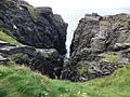 Hell's hole cavern.
 -
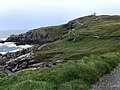 Malin head coastline looking towards the north.
 -
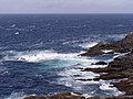 View of the rugged coast around the Head.
 -
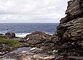 Low tide beneath the cliffs at Malin Head.


See also
[edit]References
[edit]- ^"Malin Head/Cionn Mhálanna".Placenames Database of Ireland.
- ^"Ardmalin/Ard Mhálanna".Placenames Database of Ireland.
- ^"Ireland Geographical Facts, Figures and Physical Extremities".Travel through the Ireland story...Retrieved15 September2007.
- ^Homer, Peter.A Brief History of Malin Head.Inishowen Maritime Museum & Planetarium. 2014.
- ^Durham, Anthony (8 February 2019)."Ireland"(PDF).romaneranames.uk.Retrieved8 November2021.
- ^Haggan, Irene.Malin Head(PDF).Lifford, County Donegal: Archives Service, Donegal County Council. p. 24.ISBN9780957440340.Retrieved8 November2021.
- ^"Star Wars in Ireland".ireland.Retrieved8 November2021.
- ^"Weather observing stations".met.ie.Retrieved17 January2019.
- ^"Malin Head 1981–2010 averages".Met Éireann.Retrieved27 May2015.
- ^"Absolute Maximum Air Temperatures for each Month at Selected Stations"(PDF).Met Éireann.Archived fromthe original(PDF)on 4 March 2016.Retrieved27 May2015.
- ^"Absolute Minimum Air Temperatures for each Month at Selected Stations"(PDF).Met Éireann.Archived fromthe original(PDF)on 29 January 2017.Retrieved27 May2015.
- ^Sorcha Pollak, Tim O'Brien (26 May 2017)."Ireland set for another scorcher as heatwave continues".Irish Times.Retrieved26 May2017.
- ^Homer, Peter and O'Connor, Finbar,Marconi Wireless Radio Station: Malin Head from 1902,2014.
- ^"A sign of history restored in Malin Head".Derry Journal.27 October 2015.Retrieved8 November2021– via NewsBank.
External links
[edit]- Historic mapping of the area(Ordnance Survey Ireland{ Choose "Base history and mapping" then "Historic 25-inch mapping 1888-1913" and enter55.3719929, -7.3392604to see the site of the watch tower.
- Location of weather station(OpenStreetMap)