Mazirot
Appearance
Mazirot | |
|---|---|
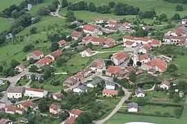
 A general view of Mazirot | |
| Coordinates:48°19′24″N6°08′51″E/ 48.3233°N 6.1475°E | |
| Country | France |
| Region | Grand Est |
| Department | Vosges |
| Arrondissement | Épinal |
| Canton | Mirecourt |
| Intercommunality | CC Mirecourt Dompaire |
| Government | |
| • Mayor(2020–2026) | Dominique Maillard[1] |
| Area 1 | 6.55 km2(2.53 sq mi) |
| Population (2021)[2] | 234 |
| • Density | 36/km2(93/sq mi) |
| Time zone | UTC+01:00(CET) |
| • Summer (DST) | UTC+02:00(CEST) |
| INSEE/Postal code | 88295/88500 |
| Elevation | 255–390 m (837–1,280 ft) (avg. 263 m or 863 ft) |
| 1French Land Register data, which excludes lakes, ponds, glaciers > 1 km2(0.386 sq mi or 247 acres) and river estuaries. | |
Mazirot(French pronunciation:[maziʁo]) is acommunein theVosgesdepartmentinGrand Estin northeasternFrance.
Inhabitants are called Mazuriens.
Geography
[edit]Mazirot is positioned betweenÉpinalandNeufchâteau,a couple of kilometres to the north-east ofMirecourtin the valley of the RiverMadonwhich itself at one point provides the frontier with the commune ofPoussayto the west.
The drive down towardsMirecourtoffers a superb panorama of that town. Meanwhile, on its western side, the entrance to Mazirot is marked by the residence of the local landlord. From here a bridge spanning the Madon leads to the slopes on the river's right bank where the village has grown up.
See also
[edit]References
[edit]- ^"Répertoire national des élus: les maires"(in French). data.gouv.fr, Plateforme ouverte des données publiques françaises. 13 September 2022.
- ^"Populations légales 2021"(in French).The National Institute of Statistics and Economic Studies.28 December 2023.
Wikimedia Commons has media related toMazirot.


