
Mecsek
This articleneeds additional citations forverification.(December 2009) |
| Mecsek | |
|---|---|
 The view from Máré Castle, nearMagyaregregy. | |
| Location | BaranyaandTolnacounties,Hungary |
| Territory | 500 km2 |
| Highest point | Zengő,682 m (2238 ft) |
| Terrain | Lower mountains |

Mecsek(Hungarian:[ˈmɛt͡ʃɛk];Croatian:Meček;Serbian:Mečekor Мечек;German:Metscheck) is a mountain range in southernHungary.It is situated in theBaranyaregion, in the north of the city ofPécs.
Etymology
[edit]The Hungarian toponym "Mecsek" derives from the sobriquet version of the name Mihály (Michael). Originally applied only to the hills adjacent toPécs,the name Mecsek was first mentioned in 16th century.[1]
Geography
[edit]The mountains cover an area of approximately 500 km2.The highest peak in the mountain range isZengő(literally translates to 'resonant'), which has an elevation of 682 metres (2,238 feet). The Mecsek Hills consist of plateau-like block mountains of a broken, folded structure. Its basis is crystalline rock of Variscan origin surmounted by Triassic and Jurassic limestone and dolomite and Tertiary formations that form the main block. The mountains are divided by a structural fault running NW to SE. The eastern part consists mainly of high ridges of sedimentary rock. The west has extensive limestone plateaux and areas dominated by sandstones of the Permian-Triassic period. There are important karst phenomena to be found on the limestone plateaux.[2]Mecsek is rich in minerals (includinguranium) compared to other territories ofHungary.The climate is mixed and represents elements of themediterraneanandcontinental climate.The territory is home to 20-30 plant species which are unknown in other parts of theCarpathian Basin.
Highest peaks
[edit]| Peak | Elevation (m) | Location |
|---|---|---|
| Zengő | 682 | Eastern Mecsek |
| Tubes | 611 | Western Mecsek |
| Hármas-hegy | 604 | Eastern Mecsek |
| Jakab-hegy | 602 | Western Mecsek |
| Dobogó | 594 | Eastern Mecsek |
| Borzas-tető | 591 | Eastern Mecsek |
| Szószék | 586 | Eastern Mecsek |
| Kis-Tubes | 577 | Western Mecsek |
| Somlyó | 572 | Eastern Mecsek |
| Szamár-hegy | 564 | Eastern Mecsek |
| Dögkút-tető | 556 | Eastern Mecsek |
| Hárs-tető | 545 | Eastern Mecsek |
| Csalán-hegy | 536 | Eastern Mecsek |
| Misina | 535 | Western Mecsek |
Political and cultural history
[edit]Due to their relative small size and medium height, the hills of Mecsek were always politically and economically connected with the neighboring lowlands ofBaranyaandTolna,serving primarily as a source of wood. The forested hills also offered substantial protection against the possible enemies.

The first significant political centre of the region was formed on the top ofJakab-hegyduring theIron Agewhich was later captured and developed into anoppidumby theCeltsin the 2nd century BC.[3]After the Roman conquest ofPannoniathe settlement's population, like in the similar cases ofBibracteorEntremontwas probably forced to move to the southern slopes of the Mecsek, where Sopianae, the predecessor ofPécsemerged.
Throughout theHungarianMiddle Agesthe valleys of the Mecsek became more densely populated, providing raw materials for the thriving episcopal city of Pécs. The castles ofSzászvár,Márévár and Kantavár were built in the era as residencies of nobles or the Church. TheOrder of Saint Paul the First Hermitpartially stemmed from the hermit communities of the Mecsek, whom the Bishop of Pécs founded a monastery at Jakab-hegy in 1225.[4]The significantPécsvárad Abbeyalso controlled substantial areas in the region.
Due to theOttoman occupation of Hungaryand the following wars, raids and over-taxation the population growth stagnated, however the everyday and religious life of the locals didn't change much.[5]The region was protected by its remoteness. After theTreaty of Karlowitz,the local nobles invited German settlers to the region. The territories east of Mecsek became a part of the German ethnic island commonly referred to asSwabian Turkey.

Significant amounts of black coal were discovered in the 19th century, the strategic resource greatly advanced the industrialization of the region. Mines were opened inPécs,SzászvárandKomlówhich were all subsequently connected to the Hungarian economy with railways. In the aftermath ofWorld War Iand the collapse ofAustria-Hungary,theKingdom of Serbs, Croats and Slovenesoccupied the region, but theTreaty of Trianoneventually left the area in the possession of Hungary.
A huge part of the German-speaking population of the area was expelled from Hungary afterWorld War II,although many German communities lingered. The socialist Hungary further developed the coal mines of Pécs and Komló. Uranium was also discovered and mined nearKővágószőlősfrom the 1950s. The Mecsek Hills were the scene of pitched battles during the Hungarian Revolution in November 1956 between Hungarian units dubbed "the Mecsek Invisibles" and the invading Soviet forces.
After the fall of communism in Hungary, the economically unsustainable mines were closed. The Mecsek now serves mostly as a recreational area with moderate forestry activities.[6]
Parts
[edit]Mecsek is divided to two parts:
Settlements
[edit]Gallery
[edit]-
 AroundJakab-hegy
 -
 Mecseknádasd- Castle from above
 -
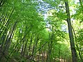 Forest nearÓbánya
 -
-
 Hills at Mecseknádasd


See also
[edit]References
[edit]- ^"Nincs rejtély a Mecsek nevének eredetében".
- ^Pierre Jolivet, Jorge Santiago-Blay, Michael Schmitt, Research of chrysomelidae, BRILL, 2009 p. 236[1]
- ^Péter Gyenizse; Péter Vass (1998)."A természeti környezet szerepe a Nyugat-Mecsek településeinek kialakulásában és fejlödésében".Földrajzi értesitö.47(2): 131–148.
- ^Buzás Gergely: A Jakab-hegyi pálos kolostor, Várak, Kastélyok, Templomok, III/4. 2007. augusztus, 8-11.
- ^Zsolt Gallina, Magyarszék régmúltja, 2001, p. 56
- ^Nyilvanos Vedesfoldrajz.ttk.pte.hu[dead link]
External links
[edit]| West-Hungarian Borderland |  | |
|---|---|---|
| Little Hungarian Plain | ||
| Transdanubia | ||
| Transdanubian Mountains | ||
| Transdanubian Hills | ||
| North Hungarian Mountains | ||
| Great Hungarian Plain | ||
46°06′N18°05′E/ 46.100°N 18.083°E