
Miyako-jima
Native name: Miyako-jima(Cung cổ đảo) | |
|---|---|
 Aerial view of Miyako Island from northwest | |
 Miyako Island Location of Miyako within Okinawa Prefecture  Miyako Island Location of Miyako within Japan  Miyako Island Location of Miyako Islands within the East China Sea | |
| Geography | |
| Location | Okinawa Prefecture |
| Coordinates | 24°46′N125°19′E/ 24.767°N 125.317°E |
| Archipelago | Miyako Islands |
| Adjacent to | East China Sea |
| Area | 158.87 km2(61.34 sq mi)[1] |
| Highest elevation | 114.8 m (376.6 ft) |
| Highest point | Nakao(ナカオ lĩnh) |
| Administration | |
| Prefecture | Okinawa Prefecture |
| Demographics | |
| Population | 45,625 (2015 national census)[1] |
| Pop. density | 275.4/km2(713.3/sq mi) |
| Ethnic groups | Ryukyuan,Japanese |
Miyako Island(Cung cổ đảo,Miyako-jima,Miyako:Myaaku(ミャーク);Okinawan:Naaku(ナーク))is the largest and the most populous island among theMiyako IslandsofOkinawa Prefecture,Japan.Miyako Island is administered as part of theCity of Miyakojima,which includes not only Miyako Island, but also five other populated islands.[2]
Geography
[edit]Miyako-jima lies approximately 300 kilometres (186 mi) southwest ofOkinawa Island.[2]With an area of 158.70 square kilometres (61.27 sq mi), Miyako is the fourth-largest island in Okinawa Prefecture.[3]The island is triangular in shape and is composed of limestone.[2]Miyako-jima is subject to drought and is frequently struck by typhoons.[2]

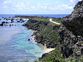
Miyako-jima is well known for its beauty, particularly theEastern Cape(Đông bình an danh giáp,Higashi-hennazaki),anationally designatedPlace of Scenic Beautyat the southeasternmost point of Miyako-jima. It is considered by many as one of the most beautiful spots inJapan.Other notable locations include Yonaha Maehama beach, Sunayama beach, Painagama Beach and the sights onIrabu-jima.There are three islands nearby which are connected by bridges to Miyako-jima, Irabujima (as of early 2015),Ikema Island(Trì gian đảo,Ikema-jima),andKurima Island(Tới gian đảo,Kurima-jima).[citation needed]
Ikema Bridge connects Miyako Island andIkema Island.It is 1,425 metres (4,675 ft)-long and was completed in February 1992.[4]Yonaha Maehama beach can be viewed from the opposite side on Kurima Island. TheMiyako language,one of severalRyukyuan languagesspoken there to some degree.[citation needed]
Climate
[edit]Miyako-jima has atropical rainforest climate(Afaccording to theKöppen climate classification), because all twelve months have a mean temperature of at least 18 °C (64 °F).
| Climate data for Miyakojima (1991−2020 normals, extremes 1937−present) | |||||||||||||
|---|---|---|---|---|---|---|---|---|---|---|---|---|---|
| Month | Jan | Feb | Mar | Apr | May | Jun | Jul | Aug | Sep | Oct | Nov | Dec | Year |
| Record high °C (°F) | 27.0 (80.6) |
27.6 (81.7) |
28.6 (83.5) |
30.7 (87.3) |
33.3 (91.9) |
35.1 (95.2) |
35.3 (95.5) |
34.2 (93.6) |
34.2 (93.6) |
32.5 (90.5) |
30.9 (87.6) |
28.8 (83.8) |
35.3 (95.5) |
| Mean daily maximum °C (°F) | 20.6 (69.1) |
21.1 (70.0) |
22.8 (73.0) |
25.1 (77.2) |
27.7 (81.9) |
30.3 (86.5) |
31.7 (89.1) |
31.3 (88.3) |
30.1 (86.2) |
27.8 (82.0) |
25.3 (77.5) |
22.2 (72.0) |
26.4 (79.5) |
| Daily mean °C (°F) | 18.3 (64.9) |
18.6 (65.5) |
20.1 (68.2) |
22.5 (72.5) |
25.0 (77.0) |
27.7 (81.9) |
28.9 (84.0) |
28.6 (83.5) |
27.6 (81.7) |
25.5 (77.9) |
23.1 (73.6) |
20.0 (68.0) |
23.8 (74.8) |
| Mean daily minimum °C (°F) | 16.3 (61.3) |
16.6 (61.9) |
17.9 (64.2) |
20.4 (68.7) |
23.0 (73.4) |
25.7 (78.3) |
26.8 (80.2) |
26.5 (79.7) |
25.6 (78.1) |
23.8 (74.8) |
21.3 (70.3) |
18.2 (64.8) |
21.9 (71.4) |
| Record low °C (°F) | 6.9 (44.4) |
7.3 (45.1) |
8.6 (47.5) |
11.4 (52.5) |
15.2 (59.4) |
17.4 (63.3) |
21.4 (70.5) |
21.2 (70.2) |
19.7 (67.5) |
17.2 (63.0) |
12.9 (55.2) |
9.6 (49.3) |
6.9 (44.4) |
| Averageprecipitationmm (inches) | 138.8 (5.46) |
119.8 (4.72) |
138.7 (5.46) |
148.7 (5.85) |
222.3 (8.75) |
194.7 (7.67) |
151.6 (5.97) |
257.4 (10.13) |
259.3 (10.21) |
157.9 (6.22) |
139.8 (5.50) |
147.2 (5.80) |
2,076 (81.73) |
| Average snowfall cm (inches) | 0 (0) |
0 (0) |
0 (0) |
0 (0) |
0 (0) |
0 (0) |
0 (0) |
0 (0) |
0 (0) |
0 (0) |
0 (0) |
0 (0) |
0 (0) |
| Average precipitation days(≥ 0.5 mm) | 14.3 | 12.0 | 12.4 | 11.3 | 11.7 | 11.0 | 10.6 | 14.0 | 13.2 | 11.2 | 12.5 | 13.9 | 148.2 |
| Averagerelative humidity(%) | 72 | 74 | 76 | 79 | 82 | 84 | 80 | 81 | 79 | 75 | 74 | 71 | 77 |
| Mean monthlysunshine hours | 85.5 | 90.3 | 116.0 | 122.9 | 149.3 | 191.9 | 241.0 | 210.9 | 179.3 | 151.9 | 112.3 | 92.7 | 1,743.9 |
| Source: Japan Meteorological Agency[5] | |||||||||||||
-
 Yonaha Maehama beach in Miyako-jima
 -
 Sunayama beach in Miyako-jima
 -
 Yonaha Maehama Beach view from Kurima Island in Miyakojima, Okinawa Prefecture, Japan.
 -
 Eastern Cape (Higashi-hennazaki) of Miyako Island
 -
 Ikema bridge connectsIkema Islandwith Miyako Island. It is 1,425 metres (4,675 ft)-long.


Culture
[edit]InMiyako Island,Miruku-potoke (the local name for theMaitreya Buddha) is traditionally believed to be an ugly god who arrives from China to create humans, animals, and crops. The handsome god Saku-potoke (the historicalShakyamuni Buddha,founder of Buddhism) then challenges him to a flower contest and steals the flower while the other sleeps. Miruku-potoke is thus defeated and forced to return to China, which is why China is a prosperous country while Miyako is not. Nearly identical creation myths arefound in Korea.[6]
Miyako is home to a unique festival calledPaantu(パーントゥ), which occurs in the ninth month of the cultural (lunar) calendar. Three men dressed in grass, leaves and mud walk around town smearing the mud on houses, cars and people. They carry sticks in one hand and an expressionless mask in the other. Legend holds that those who have been muddied by the Pantu will have a year of protection and good fortune. Owners of new homes will also invite Pantu to give a muddy 'blessing' to their homes.[citation needed]
Miyako has its own version ofsoba.Otōriis a custom of drinkingawamori,a distilled beverage native to Okinawa, Japan. It is performed by people sitting (usually around a table). One offers a toast, drinks from a small glass, and then offers some to each person at the table making a round, and usually going to the right. When the toaster makes their way back to their spot, the person who passed the otori before pours them another glass. They then announce "tsunagimasu" and drink their second glass. After a brief interval, it is then the turn of the next person to pass the otori, which continues until the celebration is ended.[citation needed]
Economy
[edit]Miyako is home tosugarcanecultivation, and producesbrown sugar.[2]Miyako jōfuis a locally produced hand-woven textile made fromramiefiber. It was formerly known asSatsuma jōfu.The textile traces its production to theTensho period,1573–92.[3][7][8]
A large tourism boom in Miyako, starting with locals and Taiwanese visitors in the early 2010s, has been steadily growing with the annual number of tourists reaching over 1 million in both 2018 and 2019.[9]The city has been struggling to cope with cruise megaships from mainland China– currently, the central port in Hirara can only handle ships as large as 50,000 tons but port officials hope to service ships as large as 200,000 tons.[10]The effects of this growing tourist industry may change the character of the island as its population is small and rural.[citation needed]
Defense
[edit]TheMiyako Straithas strategic significance. Chinese warships' passage through the straits is monitored by Japanese forces.[11]
In late April 2015, it was confirmed that the JapaneseMinistry of Defensewas in advanced planning regarding the permanent deployment of aGSDFsecurity unitto Miyakojima, to begin sometime infiscal year2016. This is part of ongoing efforts to improve the defenses of theNansei Islands.A GSDF security unit is abattalionsized force, of up to 500 personnel, whose role on Miyakojima will include providing the initial response to large-scale disasters in the area as well as acting as arapid response forceto counterattacks on remote islands within its area of responsibility.[12][13]
The Miyakojima security unit's exact composition is unclear as of April 2015, though given its known taskings, it is likely that theTOEwill include both theKomatsu LAVandsoft skinnedvehicles withall terrain capability.[citation needed]
Consideration is also currently being given to deploying GSDF units equipped withanti-aircraftandanti-ship missilesto the island.[12][13]
Tokyo has currently earmarked ¥21.2 billion yen ($205 million USD) in FY2021 to build newJapan Coast Guardpatrol boats and helicopters for the region, with plans to assign 22 ships of over 1,000 tons in the region by 2024. Miyako-jima's Coast Guard station is home to 9Shimoji-classsmall patrol vessels and aTokara-classmedium patrol vessel.[14]
Positioned in between the larger commercial ports of Ishigaki and Naha, Coast Guard facilities on Miyako's neighbor islands can provide 3Tsugarus,aKunigami,and aHaterumaclass patrol vessel based at the 11th Regional Coast Guard Headquarters inNahaand 11Kunigami-class patrol vesselsand 2Hateruma-class patrol vesselshomeportedatIshigakishould the need arise. Along with facilities for housing up to 600 crew, Ishigaki is now JCG's largest base, surpassing even that of Yokohama.[15]
Points of interest
[edit]- Miyakojima City Tropical Plant Garden
- Japan Airlinesmaintains a ticketing office on Miyako Island. It is only for domestic flights.[16]
- Miyakojima 100 km (62 mi) Ultramarathon.[17]
- Higashi-hennazakiEastern Cape of Miyako Island
Transportation
[edit]Airlines
[edit]Lanes
[edit]- Port of Hirara
- Port of Shimairi - ForŌgami-jima
Buses
[edit]- Miyako Kyoei Bus
- Yachiyo Bus
- Kyowa Bus
- Chuo Kotsu - ForShimojijima AirportinShimoji-jima
Trains
[edit]- The only railway on this island is operated in Shigira Resort, and conformed as aChairlift,which connects the westernmost with the southernmost points of railway in Japan.
- Stations:Shigira-ue- the westernmost railway station in Japan.Shigira-shita- the southernmost railway station in Japan.
See also
[edit]References
[edit]- ^ab"Remote island related materials ( ly đảo quan hệ tư liêu )"(PDF).Archived(PDF)from the original on 15 February 2020.Retrieved15 February2020.
- ^abcde"Miyakojima".Encyclopedia of Japan.Tokyo: Shogakukan. 2012.OCLC56431036.Archived fromthe originalon 25 August 2007.Retrieved18 December2012.
- ^ab"Cung cổ đảo"[Miyako-jima].Dijitaru Daijisen(in Japanese). Tokyo: Shogakukan. 2012.OCLC56431036.Archived fromthe originalon 25 August 2007.Retrieved14 December2012.
- ^"Ikema Ohashi",Trì gian ねっと,2018. Retrieved on 13 January 2018.
- ^Khí tượng sảnh / năm thường trị ( năm ・ nguyệt ごと の trị ).Japan Meteorological Agency.Retrieved19 May2021.
- ^Waida, Manabu (1991)."The Flower Contest between Two Divine Rivals. A Study in Central and East Asian Mythology".Anthropos.86(1/3): 89–90.ISSN0257-9774.JSTOR40462392.Retrieved10 June2020.
- ^"Cung cổ thượng bố"[Miyako jōfu].Dijitaru Daijisen(in Japanese). Tokyo: Shogakukan. 2012.OCLC56431036.Archived fromthe originalon 25 August 2007.Retrieved14 December2012.
- ^"Cung cổ thượng bố"[Miyako jōfu].Nihon Daihyakka Zensho (Nipponika)(in Japanese). Tokyo: Shogakukan. 2012.OCLC153301537.Archived fromthe originalon 25 August 2007.Retrieved14 December2012.
- ^"Nhập vực quan quang khách số について| hành chính tình báo | cung cổ đảo thị".city.miyakojima.lg.jp.Retrieved11 January2021.
- ^"Cruise liner influx overwhelming Miyakojima's economy".9 December 2016.
- ^"Chinese aircraft carrier sails near Okinawa islands".Japan Times.18 December 2021.
- ^ab"GSDF unit to deploy on Miyakojima".The Yomiuri Shimbun.27 April 2015.Retrieved27 April2015.
- ^ab"GSDF may permanently station hundreds of troops on Okinawan island".The Asahi Shimbun.27 April 2015.Retrieved29 April2015.
- ^Saitō, Katsuhisa (26 April 2021)."The Senkaku Confrontation: Japan's Coast Guard Faces Chinese" Patrol Ships "".Nippon Communications Foundation.Retrieved14 June2021.
- ^Kanaya, Shohei (23 December 2020)."Japan to bulk up Senkaku patrols as more Chinese ships enter area".Nikkei, Inc.Retrieved27 June2021.
- ^"JAL Group Offices Information."Japan Airlines.Retrieved on 22 July 2011. "MIYAKO Only Domestic Ticketing Available Address 223 Nishizato Hirara Miyako City, 906-0012"Map
- ^Cung cổ đảo 100kmワイドーマラソン <1 nguyệt >Retrieved 20 September 2015(in Japanese)
External links
[edit]- Miyakojima Website (Japanese)
- Pantu in Japanese
- WLCM.net,Miyako Folklore English translation by Mark Wisniewski
- WLMC.net,Miyako Natural Science English translation by Mark Wisniewski
| Core city | ||
|---|---|---|
| Cities | ||
| Districts | ||
| International | |
|---|---|
| National | |