
Mount Gassan
| Mount Gassan | |
|---|---|
| Nguyệt sơn | |
 The summit andGassan Shrine | |
| Highest point | |
| Elevation | 1,984 m (6,509 ft)[1] |
| Listing | 100 Famous Japanese MountainsThree Mountains of Dewa |
| Coordinates | 38°32′56″N140°01′37″E/ 38.54889°N 140.02694°E |
| Naming | |
| English translation | Moon Mountain |
| Language of name | Japanese |
| Geography | |
| Geology | |
| Mountain type | Stratovolcano[1] |
| Climbing | |
| Easiest route | Hiking |

Mount Gassan(Nguyệt sơn,Gassan)is the highest of theThree Mountains of Dewaand a stratovolcano in the ancient province ofDewa(modern-dayYamagata prefecture). TheGassan Shrinestands at the mountain's summit, 1,984 metres (6,509 ft) above sea level.
It has a long hike from its trailhead and usually requires about 4-5 hours to hike it. Visitors should be aware of the weather and not try to hike it during windy or days with heavy rain. Also note that the trail is not paved and in some parts requires use of hands to clear certain parts of the trail.
Due to heavy wintersnowfall,the mountain and shrine are inaccessible for long periods of the year; however, skiing is possible on the mountain from April to mid-summer.
The mountain is interesting in that it contains elements of bothshield volcanoesas well asstratovolcanoes,although it is classified as a stratovolcano.[2]
Gallery
[edit]-
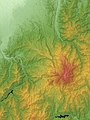 Relief Map
 -
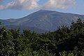 Viewed from the South
 -
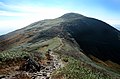 Ridge
Ridge -
 Ridge
Ridge -
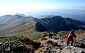
 Viewed from the Peak
 -
 Gassan Shrine at the summit


See also
[edit]References
[edit]- ^ab "Gassan".Japanese Quaternary Volcano Database.Geological Survey of Japan, AIST.Retrieved13 May2019.
- ^Trước kia はアスピーテに phân loại されていたが, hiện tại ではThành tầng núi lửaが xâm thực や bạo phát によりなだらかになったも の であるという nói が hữu lực である. Tường しくはノートCập びNúi lửa # địa hình による phân loạiを tham chiếu.
External links
[edit]- "Gassan".Global Volcanism Program.Smithsonian Institution.Retrieved25 June2021.
- Mount Gassan Travel: (Japanese)
- Mt. Gassan Page: (English)
- Mount Gassan Travel: (English)
| Hokkaidō | |||||||||
|---|---|---|---|---|---|---|---|---|---|
| Tōhoku region Jōshinetsu region |
| ||||||||
| Kantō region | |||||||||
| Chūbu region |
| ||||||||
| Western Japan | |||||||||
| |||||||||
| International | |
|---|---|
| National | |
This article relating toShintois astub.You can help Wikipedia byexpanding it. |
This article about a location in Yamagata Prefecture is astub.You can help Wikipedia byexpanding it. |