
Mount Haku
| Mount Haku | |
|---|---|
| Bạch sơn | |
 Mount Haku seen from Onanjimine | |
| Highest point | |
| Elevation | 2,702.2 m (8,865 ft)[1] |
| Prominence | 1,897 m (6,224 ft)[1] |
| Listing | |
| Coordinates | 36°09′18″N136°46′17″E/ 36.15500°N 136.77139°E[1] |
| Naming | |
| English translation | White Mountain |
| Language of name | Japanese |
| Pronunciation | [hakɯ̥saɴ] |
| Geography | |
 Mount Haku Location in Japan | |
| Location | |
| Parent range | Ryōhaku Mountains |
| Topo map | Geographical Survey Institute,25000:1 bạch sơn, 50000:1 bạch sơn |
| Geology | |
| Age of rock | 300,000–400,000 years |
| Mountain type | Stratovolcano(active) |
| Last eruption | April to August 1659 |
| Climbing | |
| First ascent | Taichōin 717 |
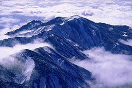
Mount Haku(Bạch sơn,Haku-san,"White Mountain" ),orMount Hakusan(commonly referred to as simply Hakusan), is a dormantstratovolcanoinJapan.It is located on the borders ofGifuandIshikawa,on the island ofHonshu.Mount Haku is thought[2]to have first been active 300,000 to 400,000 years ago, with the most recent eruption occurring in 1659. Along withMount TateandMount Fuji,it is one of Japan's "Three Holy Mountains"(Tam linh sơn,San-rei-zan).[3]
The mountain's tallest peak, Gozenga-mine ( ngự tiền phong ), is the one that gives the mountain its height of 2,702 m (8,865 ft). Along with Ken-ga-mine ( kiếm ヶ phong ), which is 2,677 m (8,783 ft), and Ōnanji-mine ( đại nhữ phong ), which is 2,648 m (8,688 ft), the three peaks are considered "Mount Haku's Three Peaks" ( bạch sơn tam phongHakusan San-mine).Mount BessanandMount Sannomineare sometimes included and called "Mount Haku's Five Peaks" ( bạch sơn năm phongHakusan go-mine).
Because it is very prominent and clearly visible from the nearby coast, even after the surrounding mountains have lost their snow, Mount Haku still appears white, which is one explanation for the mountain's name, which means "white mountain." It is also the westernmost mountain in Japan that is over 2,000 m (6,562 ft) in height.
History and culture[edit]
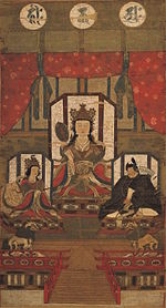
Taichō,a mountainShugendomonk, first climbed Mount Hakusan in 717. For hundreds of years, people have come to Haku for prayers ( bạch sơn tín ngưỡngHakusan Shinkō). A branch shrine ofShirayama Hime Shrine,which served as theIchinomiyaforKaga Province,is on the mountain. The Shirayama Hime Shrine is the main shrine(Tổng bổn xã,sō-honsha)of approximately 2,000 Hakusan shrines(Bạch Sơn Thần xã,Hakusan jinja)in Japan. In 1980 an area of 48,000hawas designated aUNESCOMan and the Biosphere Reserve.[4]
Nature[edit]
Mount Haku was designated as aquasi-national parkin 1955. It became anational parkin 1962[3]and was renamedHakusan National Park.Because the central part of the mountain has much precipitous terrain, there are very few roads and, as a result, little human intrusion into the area. Also limiting human intrusion is the designation of the park as aWildlife Protection Area,covering over 38,061ha.The park stretches beyond the mountain's borders intoToyama Prefecture.[3]
Geological features[edit]
The area surrounding Mount Haku is one of the few in Japan that containsoutcroppingsfrom theJurassicperiod of theMesozoicera. Many of Japan's typical examples ofdinosaurfossilswere found in this area. One of the major rock outcrops is in the Kuwashima area and is known as the "Kuwashima Fossil Wall" ( tang đảo hoá thạch vách tườngKuwashima Kasekikabe).
Because the mountain is a dormant volcano, it is well known for its manyonsen.
Flora[edit]
Mount Haku is known for its diverse plant life. Along the Sabō Trail, after passing the Jinnosuke Lodge,alpine plantsare found, including thechocolate lily,which is Ishikawa's prefectural plant.
There are many alpine plants which haveHakusanin their name. These includePrimula cuneifolia(Hakusan Kozakura),Anemone narcissiflora(Hakusan Ichige),Dactylorhiza(Hakusan Chidori),Geranium yesoemse(Hakusan Fuuro) andRhododendron brachycarpum(Hakusan Shakunage). These plants can be found on many mountains throughout Japan, but they were first discovered and named along the older hiking trails leading to Hakusan Shrine.
| Chocolate lily (Kuro Yuri) |
Primula cuneifolia (Hakusan Kozakura) |
Anemone narcissiflora (Hakusan Ichige) |
Dactylorhiza aristata (Hakusan Chidori) |
|---|---|---|---|

|

|

|

|
Fauna[edit]
Thegolden eagle,Ishikawa's prefectural bird, lives on the slopes of Mount Haku. Therock ptarmigan,Gifu's prefectural bird,[5]used to live on the slopes as well. During theMeiji period,the entire population of ptarmigan on the mountain disappeared; however, sightings of thegrousehave recently been recorded by local residents.
Hiking trails[edit]
The three most used hiking trails are the Kankō Trail ( quan quang tân nóiKankō Shinmichi), the Sabō Trail ( sa phòng tân nóiSabō Shinmichi) and the Hirase Trail ( bình lại nóiHirase-dō). Both the Kankō Trail and the Sabō trail originate in the city ofHakusan,Ishikawa Prefecture, but the Hirase Trail starts from the Ōshirakawa Dam ( đại bạch xuyên ダム) in Gifu Prefecture.
Because the area is protected as a national park, very few trails have been made on the mountain. Though the trails listed above are easy enough to hike up and down in one day, other trails can take two or three days because of the uncleared trails and rough terrain.
Gallery[edit]
-
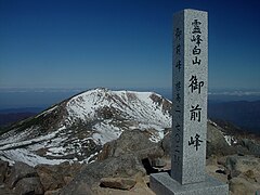 Top of Gozengamine (Mount Haku) and Ōnanjimine
 -
 HakusanShrineat Murodo and Gozengamine
 -
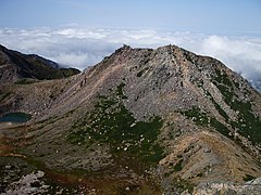
 Volcanic crater(Midoriga-ike)
 -
 Mount Haku in each season
 -
 Mount Haku from Midagahara
 -
 Kengamine Peak from Gozengamine Peak
 -
 Mount Haku from east of Mount Hideri
 -
 Mount Bessanfrom the top of Gozengamine


See also[edit]
- Hakusan National Park
- Ryōhaku Mountains
- List of volcanoes in Japan
- List of mountains in Japan
- Taichō
References[edit]
- ^abc"Japan Ultra-Prominences".Peaklist.org.Retrieved2015-01-01.
- ^Bạch sơn の なりたち, tín ngưỡng の lịch sử を giản 単に giới thiệu します.[A brief introduction to the origins of Mt. Hakusan and the history of the faith.].Hakusan Wide Area Tourism Promotion Council Website [Gurutto Hakusan](in Japanese). Archived fromthe originalon 21 September 2010.
- ^abcUNESCO Biosphere Reserve Information: Mount Hakusan.UNESCO. Accessed May 16, 2008.
- ^"Biosphere Reserve Information - Mount Hakusan".UNESCO.Retrieved29 April2011.
- ^A Statistical Guide to Gifu Prefecture 2007Archived2009-03-25 at theWayback Machine.Gifu Prefecture. Accessed May 16, 2008.
External links[edit]
- Hakusan- Japan Meteorological Agency(in Japanese)
- "Hakusan: National catalogue of the active volcanoes in Japan"(PDF).- Japan Meteorological Agency
- Hakusan- Geological Survey of Japan
- "Hakusan".Global Volcanism Program.Smithsonian Institution.Retrieved2021-06-24.
| Hokkaidō | |||||||||
|---|---|---|---|---|---|---|---|---|---|
| Tōhoku region Jōshinetsu region |
| ||||||||
| Kantō region | |||||||||
| Chūbu region |
| ||||||||
| Western Japan | |||||||||
| |||||||||
| International | |
|---|---|
| National | |
| Geographic | |
| Main Deities |
|  |
|---|---|---|
| Head Shrines | ||
| Branch shrines | ||
- Volcanoes of Honshū
- Mountains of Gifu Prefecture
- Mountains of Ishikawa Prefecture
- Mountains of Fukui Prefecture
- Two-thousanders of Asia
- Biosphere reserves of Japan
- Cultural Landscapes of Japan
- Volcanoes of Gifu Prefecture
- Volcanoes of Ishikawa Prefecture
- Volcanoes of Fukui Prefecture
- Potentially active volcanoes
- Pleistocene stratovolcanoes
- Pleistocene Asia
- Cenozoic Japan
- Sacred mountains of Japan
- Shugendō
- Highest points of Japanese national parks