
Mount Scenery
| Mount Scenery | |
|---|---|
 Sabawith Mount Scenery's peak in the clouds | |
| Highest point | |
| Elevation | 887 m (2,910 ft) |
| Prominence | 887 m (2,910 ft) |
| Listing | Country high point |
| Coordinates | 17°38′06″N63°14′21″W/ 17.63500°N 63.23917°W |
| Geography | |
 Mount Scenery location in the Lesser Antilles  Mount Scenery Mount Scenery (Lesser Antilles) | |
| Location | Saba,Caribbean Netherlands |
| Geology | |
| Mountain type | Stratovolcanowithlava dome |
| Volcanic arc | Lesser Antilles Volcanic Arc |
| Last eruption | 1640 |
Mount Sceneryis adormant volcanoin theCaribbean Netherlands.Itslava domeforms the summit of theSabaislandstratovolcano.At an elevation of 887 m (2,910 ft),[1]it is the highest point in both theKingdom of the Netherlands,and, since thedissolution of the Netherlands Antilleson 10 October 2010, the highest point in theNetherlandsproper.
The Saba volcano is potentially dangerous. It is currently classified as "dormant", which means it is an active volcano that is not erupting now, but could erupt in the future.[2]The last eruption was in or around the year 1640[1]which included explosions andpyroclastic flows.The most recent major eruption was at least 5,000 years ago.[3]According to the U.S.Global Volcanism Program,Saba's volcano is the northernmost active volcano in the Caribbean.[1]
On 2 September 2019, Mount Scenery Nature Park was elevated to the status of national park.[4]It has a hiking trail to its summit, which is one of Saba's biggest tourist attractions. Along the way up the mountain are the multiple climate zones of Saba, including acloud forestat the summit.[5][6]
History
[edit]The formation of Mount Scenery began about 500,000 years ago, when thesubaerialpart of Saba began forming.[7]About 100,000 years ago, another phase of volcanic activity created the hills that surroundThe Bottom.[7]It was likely during this time that Mount Scenery'slava domesummit formed.[8]The last major eruption happened about 5,000 years ago, during theHoloceneera. The volcano was plugged by a massivebasalt rock,which is why there is no typicalvolcanic craterat Mount Scenery's summit.[7]
Volcanic activity on Saba occurred up to the mid-17th century, just beforeEuropean settlement on the island.[7]Some of this activity may have occurred whileAmerindianswere living on the island, as it is believed that Amerindians inhabited the island (at least periodically) for approximately 2,500 years before Europeans arrived.[7]


During the early years of European settlement, Mount Scenery (known locally as "The Mountain" through the mid-20th century) was an important location for farming,[9]and through the late 19th and early 20th century, the majority of Saban families were dependent upon "farming The Mountain" or fishing.[10][6]Common foodstuffs farmed includedbananas,white potatoes,sweet potatoes,tannias,cabbage,pumpkins,andonions.[6]Farmers from the village ofWindwardsidefarmed an area of The Mountain called "Big Rendez-Vous", and farmers from the village ofSt. Johnsfarmed an area called "Little Rendez-Vous".[10]Today, most of the farmland on Mount Scenery is gone; although ruins of old farmland are visible on some of Saba's hiking trails.[11]
In the late 1960s, a stone stairway was built from Windwardside to the summit of Mount Scenery, consisting of 1,064 steps.[12][13][14]The stairway was built by hand, step by step, by local Sabans.[13]Today the stairway is known as the Mount Scenery Trail, and is a popular hiking trail.[15][16][17]
In 2018, Mount Scenery Nature Park was established.[18][19]The park covers an area of approximately 3.42 square kilometres (1.32 sq mi), which is about 26% of Saba's total area.[19]The park supportseco-tourism,maintains thetrail system,protectsbiodiversity,and preserves historical structures.[19]In 2019, the park was elevated to the status of national park, and is now called Mount Scenery National Park.[18]
Volcanic monitoring
[edit]Scientific monitoring of Mount Scenery's volcanic activity began in the 1970s. From 1978 to 1983, theLamont–Doherty Geological Observatorymonitored Saba'sseismicactivity.[7][20]Between 1992 and 2004, theSeismic Research Center in Trinidadoperated aseismometeron Mount Scenery's summit.
In 2006, theRoyal Netherlands Meteorological Institute(KNMI) began monitoring seismic activity related to Mount Scenery.[20]As of 2018, the KNMI had four seismic monitoring stations on Saba.[20]In 2022, the KNMI installed four cost-effectiveGNSSunits Saba, one of which is located at the top of Mount Scenery. The units aresolar-powered,and were installed as part of a pilot study to assess the suitability of cost-effective GNSS use for monitoring volcanic activity.[21][22]
Hiking
[edit]
Mount Scenery Trail
[edit]The Mount Scenery Trail is Saba's most popular hiking trail.[15][16][17]The trail is a strenuousout-and-backtrail, which goes up 1064 steps to Mt. Scenery's summit and back.[23]It takes about 90 minutes each way.[24]
The maintrailheadfor Mt. Scenery Trail is located on the road just outsideWindwardside,across from the Trail Shop.[25]There are two alternative accesses to the trail: one from the end of the Mountain Road, which reduces the hike by about 25 minutes;[23]and one from the Bud's Mountain Trail, which joins the Mt. Scenery trail at the highest shelter.[23]At the top of the trail, there are three different viewpoints of the island.[26]
The lower portion of the trail goes throughrainforestandsecondary rainforest.[27]Here hikers can seetree ferns,Elephant Ears (Taro), wild plantains (Heliconia), Mountain Palm (Euterpe precatoria), and "Mountain Manna" (Begonia retusa).[27][28]The upper 50 metres (160 ft) of the trail is acloud forestcalled the Elfin Forest.[5][28]Here hikers can seeMountain Mahogany,[29][5]as well asorchids,liverworts,mosses,ferns,and otherepiphytes.[28][5]
The Elfin Trail
[edit]The Elfin Trail is Saba's newest hiking trail, established in 2018.[30]The trail begins on theSandy Cruz Trail,and ends when it intersects with the Mount Scenery Trail.[31]The hike takes about 1 hour one-way.[31]
The trail follows the old paths used by farmers of earlier generations.[30]Hikers of the trail will go through three ecosystems:woodlands,rainforest,cloud forest.[30]Hikers can see Elephant Ears (Taro),Mountain Fuchsia,Maxillaria Orchids,largeBanana trees,and other flora.[31]The trail also provides views of Old Booby Hill,Cove Bay,andthe airport.[31]
Communications technology
[edit]
In 1972, BritishCable & Wirelessbegan construction of amicrowave relay stationat the top of Mount Scenery.[12][32]The purpose of the microwave relay was to link the islands ofAntiguaandTortollavia Saba.[12]Though no longer in operation, the relay station and tower still sit at the top of Mount Scenery today.[13]
JRCC Curaçao(theDutch Caribbean Coast GuardJoint Rescue Coordination Center at Curaçao),[33]has one of its emergency monitoring stations located on Mount Scenery.[34]The station, "DSC Station Mt. Scenery",[34]is aDigital Selective Calling(DSC) station, meaning that it has "equipment that allows mariners to instantly send or receive automatically formatted distress alerts to vessels and coast stations in the area."[35]DSC Station Mt. Scenery provides 24-hour monitoring with a range of 70 nautical miles (130 km; 81 mi).[34][36]
On the lower slopes of Mount Scenery in the village ofSt. Johns,theSt. John's Lighthousewas constructed. The navigational aid is a 15 metres (49 ft) high tower mounted to a 1-story white concrete base.[37]Its light emits two white flashes every 10 seconds.[37]
Gallery
[edit]-
 Mount Scenery in the clouds
 -
 One of the Mount Scenery trailheads
 -
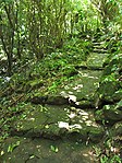 Mount Scenery Trail steps
 -
 View from Mount Scenery withWindwardsidein the front
 -
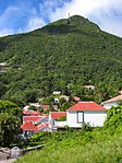 The peak as seen from Windwardside
 -
 The peak as seen from LowerHell's Gate


See also
[edit]- List of volcanoes in the Netherlands
- Vaalserberg- the highest point in the Netherlands in Europe
References
[edit]- ^abc"Saba".Global Volcanism Program.Smithsonian Institution.Retrieved30 August2020.
- ^"Active, dormant, and extinct: Clarifying confusing classifications | U.S. Geological Survey".usgs.gov.Retrieved2024-02-08.
- ^"About Saba".Saba Tourism.2018-06-21.Retrieved2024-02-07.
- ^"National park status for Mount Scenery Nature Park - Saba News".saba-news.Archived fromthe originalon 2019-09-07.
- ^abcd"Hiking: The Summit of Mt. Scenery".Saba Tourism.2022-03-10.Retrieved2024-02-07.
- ^abcCrane, Julia G. (1971).Educated to Emigrate: The Social Organization of Saba.Round the World Publishing.ISBN978-90-232-0702-3.
- ^abcdefRoobol, M. John (2004).Volcanology of Saba and St. Eustatius, Northern Lesser Antilles: Textbd.Koninklijke Nederlandse Akademie van Wetenschappen.
- ^"Saba".Global Volcanism Program.Smithsonian Institution.Retrieved30 August2020.
- ^Price, A. Grenfell (1934)."White Settlement in Saba Island, Dutch West Indies".Geographical Review.24(1): 42–60.Bibcode:1934GeoRv..24...42P.doi:10.2307/209493.ISSN0016-7428.JSTOR209493.
- ^ab"The Mountain".The Saba Islander.2019-08-28.Retrieved2024-02-08.
- ^"Hiking | Saba Tourism".2022-03-10.Retrieved2024-02-08.
- ^abcHartog, Johannes (1975).History of Saba.Netherlands Antilles: Saba Artisan Foundation.
- ^abcGreaves-Gabbadon, Sarah (2015-08-28)."Hiking Saba's Mount Scenery".Caribbean Journal.Retrieved2024-02-09.
- ^"The Chronological History of Saba".The Saba Islander.2021-02-06.Retrieved2024-02-10.
- ^ab"Hiking on Saba | Sea Saba Dive Center".seasaba.Retrieved2024-01-15.
- ^abGreaves-Gabbadon, Sarah (March 27, 2013)."This 5-square-mile Island Has a 'Disappearing Beach' — and It's Called the 'Unspoiled Queen of the Caribbean'".Travel + Leisure.
- ^abWerner, Laurie."Ultimate Caribbean Seclusion: The Under The Radar, Newly Reopened Island Of Saba".Forbes.Retrieved2024-01-15.
- ^ab"National park status for Mount Scenery Nature Park".BES Reporter.Sep 4, 2019.
- ^abc"Mount Scenery National Park".Saba Conservation Foundation.Retrieved2024-02-08.
- ^abcDe Zeeuw-van Dalfsen, Elske; Sleeman, Reinoud (2018)."A Permanent, Real-Time Monitoring Network for the Volcanoes Mount Scenery and The Quill in the Caribbean Netherlands".Geosciences.8(9): 320.Bibcode:2018Geosc...8..320D.doi:10.3390/geosciences8090320.ISSN2076-3263.
- ^de Zeeuw-van Dalfsen, Elske (2023).Volcano Monitoring Updates Saba and St. Eustatius 2017 - 2023(PDF)(Report).Royal Netherlands Meteorological Institute.
- ^"Seismic and Volcano Monitoring Team on Saba".Saba News.2023-11-08.Retrieved2024-02-10.
- ^abc"Plan your Hike".Saba Conservation Foundation.Retrieved2024-02-07.
- ^"Mt. Scenery | Saba Tourism".2022-03-14.Retrieved2024-01-15.
- ^"The Trail Shop | Saba Tourism".2018-06-22.Retrieved2024-01-15.
- ^"Hiking: Mt. Scenery".Saba Tourism.2022-03-10.Retrieved2024-02-07.
- ^ab"Hiking: Lower Slopes".Saba Tourism.2022-03-10.Retrieved2024-02-07.
- ^abc"Hiking Trails: Flora and Fauna".sabapark.org.Saba Conservation Foundation.Retrieved2024-02-07.
- ^"Species Action Plan: Mountain mahogany"(PDF).Dutch Caribbean Biodiversity Database.2020.
- ^abcStaff, Caribbean Journal (2018-08-20)."A New Hiking Trail in Saba".Caribbean Journal.Retrieved2024-02-08.
- ^abcd"Plan your Hike".Saba Conservation Foundation.Retrieved2024-02-08.
- ^MacRae, D.R.; De Meyer, K. (July 2018).Mount Scenery Nature Park Management Plan(PDF)(Report).
- ^"The Dutch Caribbean Coast Guard (DCCG)".sintmaartengov.org.Retrieved2024-02-10.
- ^abc"Chapter 4: Distress, Emergency, and Safety Traffic".Radio Navigational Aids(PDF).Vol. 117. Springfield, VA:National Geospatial-Intelligence Agency.2014. p. 81.
- ^"Chapter 3: Radio Navigational Warnings".Radio Navigational Aids(PDF).Vol. 117. Springfield, VA:National Geospatial-Intelligence Agency.2014. p. 3.
- ^Master Plan of Shore-Based Facilities for the Global Maritime Distress and Safety System(PDF)(Report).International Maritime Organization.30 July 2018.
- ^ab"Lighthouses of Saba and Sint Eustatius".ibiblio.org.Retrieved2024-01-24.
| Populated places | |||
|---|---|---|---|
| Other locations | |||
| Transport | |||
| Education | |||
| Heraldry | |||
| Culture | |||