
Mount Washiba
| Mount Washiba | |
|---|---|
| Thứu vũ nhạc | |
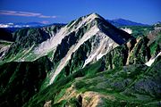
 Mount Washiba seen from Mount Mitsumatarenge | |
| Highest point | |
| Elevation | 2,924 m (9,593 ft)[1] |
| Listing | List of mountains in Japan 100 Famous Japanese Mountains |
| Coordinates | 36°25′35″N137°36′10″E/ 36.42639°N 137.60278°E |
| Naming | |
| English translation | Eagle wing Mountain |
| Language of name | Japanese |
| Geography | |
 Mount Washiba Location in Japan | |
| Location | Toyama Prefecture,Nagano Prefecture,Japan |
| Parent range | Hida Mountains |
| Geology | |
| Mountain type | Stratovolcanoes,shield volcanoes,lava domes |
| Last eruption | 12,000 years ago |
Mount Washiba(Thứu vũ nhạc,Washiba-dake)is a peak and complex ofvolcanoesin theHida Mountainsrange of theJapanese Alpsat 2924m, located inNagano PrefectureandToyama Prefecture,centralHonshu,Japan.It is listed in100 Famous Japanese Mountains.[2]
Geography
[edit]Mount Washiba is the29th-tallest mountain in Japan.
Gallery
[edit]-
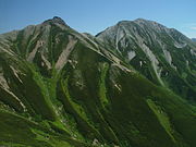
 Mount Washiba seen from Suisho Mountain Villa
 -
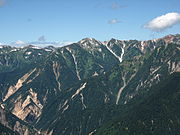
 Mount Washiba seen from Mount Jii
 -
 Mount Washiba seen from Tsubakuro Mountain Villa
 -
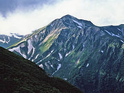
 Mount Washiba seen from Mount daitenjo
 -
 Mount Washiba seen from Sugoroku Mountain Villa


References
[edit]- ^"Nhật Bản の chủ な núi cao độ cao ( phú sơn huyện の sơn )".Quốc thổ địa lý viện.Retrieved2010-01-05.
- ^『 Nhật Bản trăm tên sơn 』Thâm điền lâu di( ),Mặt trời mới mọc tin tức xã,1982 năm,ISBN4-02-260871-4,pp. 202-205
See also
[edit]| Hokkaidō | |||||||||
|---|---|---|---|---|---|---|---|---|---|
| Tōhoku region Jōshinetsu region |
| ||||||||
| Kantō region | |||||||||
| Chūbu region |
| ||||||||
| Western Japan | |||||||||
| |||||||||