Nallıhan
Nallıhan | |
|---|---|
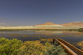
 Nallıhan Bird Paradise Sanctuary | |
 Map showing Nallıhan District in Ankara Province | |
| Coordinates:40°11′01″N31°21′02″E/ 40.18361°N 31.35056°E | |
| Country | Turkey |
| Province | Ankara |
| Government | |
| • Mayor | Ertunç Güngör (CHP) |
| Area | 2,079 km2(803 sq mi) |
| Elevation | 625 m (2,051 ft) |
| Population (2022)[1] | 26,553 |
| • Density | 13/km2(33/sq mi) |
| Time zone | UTC+3(TRT) |
| Postal code | 06920 |
| Area code | 0312 |
| Website | www |
Nallıhanis a municipality anddistrictofAnkara Province,Turkey.[2]Its area is 2,079 km2,[3]and its population is 26,553 (2022).[1]It is 157 km from the city ofAnkara.Its elevation is 625 m.
Nallıhan is one of many towns that claim to be the burial place ofTaptuk Emre,who lived in the 12-13th century, and was the teacher of the folk poet and dervishYunus Emre.NallıhanDavutoğlan Bird Paradiseattracts local and foreign tourists.[4]
Name
[edit]Nallıhan is named after acaravanseraion the ancientSilk Roadto the Orient next to the riverNallı.There has been a settlement here for thousands of years.
Today
[edit]Silk farming,a tradition for centuries in Nallıhan, continues still in many homes.[5]Today, the town is known for itssilk needlework,[5]and local cuisine including stuffed vine-leaves,pilav,pumpkin dessert, gozleme (flat bread with cheese and potatoes filling), and many other types of more fine pastries such asbaklavawith locally grown walnut. The countryside is used for growing rice, wheat, barley, grapes, apples, tomatoes, and lavender. Almost everything grows in the fertile soils of Nalliah such as figs, olives, mulberry, pears, apple, persimmons, quince, hazelnut, pecans, squashes, beans, and melons.
Visitors can walk through the idyllic Ottoman villages (e.g. Akdere) and have local cuisine in the Ottoman era Caravan Palace.
Composition
[edit]

There are 84neighbourhoodsin Nallıhan District:[6]
- 100.Yıl
- Akdere
- Aksu
- Alanköy
- Aliağa
- Aliefe
- Alpağut
- Arkutça
- Aşağıbağdere
- Aşağıbağlıca
- Aşağıkavacık
- Atatürk
- Atça
- Aydoğmuş
- Belenalan
- Belenören
- Beyalan
- Beycik
- Beydili
- Bozyaka
- Çalıcaalan
- Çamalan
- Çayırhan
- Cendere
- Çiller
- Çive
- Çulhalar
- Danişment
- Davutoğlan
- Demirköy
- Dereköy
- Doğandere
- Döğmeci
- Eğri
- Emremsultan
- Epçeler
- Ericek
- Eymir
- Fatih
- Gökçeöz
- Güzelöz
- Hacıbey
- Hacıhasanlar
- Hıdırlar
- İslamalan
- Kabaca
- Kadıköy
- Karacasu
- Karahisar
- Karahisargölcük
- Karahisarkozlu
- Karaköy
- Kavakköy
- Kulu
- Kuruca
- Kuzucular
- Meyildere
- Meyilhacılar
- Nallıdere
- Nallıgölcük
- Nasuhpaşa
- Nebioğlu
- Ömerşeyhler
- Osmanköy
- Öşürler
- Ozan
- Sarıkaya
- Sarıyar
- Sobran
- Soğukkuyu
- Subaşı
- Tekirler
- Tekke
- Tepe
- Uluhan
- Uluköy
- Uzunöz
- Yakapınar
- Yazı
- Yenice
- Yeşilyurt
- Yukarıbağdere
- Yukarıbağlıca
- Yukarıkavacık
Climate
[edit]Nallıhan has acold semi-arid climate(Köppen:BSk),[7]with hot, dry summers, and chilly, damp, occasionally snowy winters.[8]
| Climate data for Nallıhan (1991–2020) | |||||||||||||
|---|---|---|---|---|---|---|---|---|---|---|---|---|---|
| Month | Jan | Feb | Mar | Apr | May | Jun | Jul | Aug | Sep | Oct | Nov | Dec | Year |
| Mean daily maximum °C (°F) | 5.3 (41.5) |
8.4 (47.1) |
13.2 (55.8) |
18.6 (65.5) |
24.3 (75.7) |
28.6 (83.5) |
32.2 (90.0) |
32.5 (90.5) |
28.0 (82.4) |
21.3 (70.3) |
13.3 (55.9) |
7.0 (44.6) |
19.4 (66.9) |
| Daily mean °C (°F) | 1.3 (34.3) |
3.1 (37.6) |
6.9 (44.4) |
11.6 (52.9) |
16.7 (62.1) |
20.7 (69.3) |
24.0 (75.2) |
24.3 (75.7) |
19.9 (67.8) |
14.2 (57.6) |
7.4 (45.3) |
2.9 (37.2) |
12.8 (55.0) |
| Mean daily minimum °C (°F) | −2.3 (27.9) |
−1.3 (29.7) |
1.5 (34.7) |
5.2 (41.4) |
9.5 (49.1) |
13.2 (55.8) |
16.0 (60.8) |
16.3 (61.3) |
12.1 (53.8) |
7.7 (45.9) |
2.3 (36.1) |
−0.6 (30.9) |
6.7 (44.1) |
| Averageprecipitationmm (inches) | 42.49 (1.67) |
34.95 (1.38) |
36.41 (1.43) |
36.82 (1.45) |
32.84 (1.29) |
33.11 (1.30) |
14.92 (0.59) |
10.09 (0.40) |
13.9 (0.55) |
29.64 (1.17) |
25.82 (1.02) |
42.69 (1.68) |
353.68 (13.92) |
| Average precipitation days(≥ 1.0 mm) | 7.3 | 6.5 | 6.6 | 5.9 | 6.6 | 5.0 | 2.5 | 2.2 | 2.8 | 5.0 | 4.9 | 7.1 | 62.4 |
| Averagerelative humidity(%) | 76.5 | 71.5 | 66.2 | 61.7 | 60.5 | 59.1 | 54.7 | 55.1 | 57.4 | 65.1 | 71.3 | 77.7 | 64.6 |
| Source:NOAA[9] | |||||||||||||
Places of interest
[edit]- Juliopolis- archaelogical site from theRomanandByzantineeras.[10]
- Nallıhan Kuş Cenneti - Sarıyar reservoir is teeming with bird-life. It is a natural habitat for several endangered bird species in Turkey.
- Kocahan - Ottoman vizier Nasuh Pasha stopped by this place in 1599 and made it built. It is in a rectangular shape and has cafes and shops in its 46 rooms.[11]
- Ilıca/Uyuzsuyu waterfall - The waterfall that reside in the road toGöynük,is the only waterfall in the borders of Turkey's capital, Ankara. It got its name "Uyuzsuyu" because there is a belief that its water cures skin diseases.[12]
- TheMount Sarıçalı National Park(Turkish:Sarıçalı Dağı Milli Parkı) is located next toÇulhalarvillage in the northeast and 25 km (16 mi) northwest of Nallıhan.[13]
See also
[edit]References
[edit]- ^ab"Address-based population registration system (ADNKS) results dated 31 December 2022, Favorite Reports"(XLS).TÜİK.Retrieved22 May2023.
- ^Büyükşehir İlçe Belediyesi,Turkey Civil Administration Departments Inventory. Retrieved 8 June 2023.
- ^"İl ve İlçe Yüz ölçümleri".General Directorate of Mapping.Retrieved22 May2023.
- ^Selahattin Sönmez (10 June 2016)."Photographers flock to Nallıhan Bird Paradise".Hurriyet Daily News.
- ^ab"Nallıhan'ın ipek oyası".Hürriyet(in Turkish). 11 December 2017.Retrieved21 April2024.
- ^Mahalle,Turkey Civil Administration Departments Inventory. Retrieved 22 May 2023.
- ^"Table 1 Overview of the Köppen-Geiger climate classes including the defining criteria".Nature: Scientific Data.
- ^"Kar Örtülü Gün Sayısı"(PDF).MGM.
- ^"World Meteorological Organization Climate Normals for 1991-2020 — Nallıhan".National Oceanic and Atmospheric Administration.RetrievedJanuary 16,2024.
- ^"Juliopolis"(in Turkish). Nallıhan Kaymakamlığı.Retrieved21 April2024.
- ^"(Turkish) Official website of the district," Historical heritages "".
- ^"(Turkish)Official website of the district," cultural heritages. "".
- ^"Sarıçalı Dağı Milli Park Olarak İlan Edildi"(in Turkish). Tarım ve Orman Bakanlığı 9. Bölge Müdürlüğü. 28 October 2021.Archivedfrom the original on 10 April 2024.Retrieved10 April2024.
External links
[edit]- Nallıhan website(in Turkish)
- District governor's official website(in Turkish)
- Governorship of Nallıhan, Turkey."Geographical information on Nallıhan district of Ankara"(in Turkish). Archived fromthe originalon 2008-03-03.
- District municipality's official website(in Turkish)
- A local information website(in Turkish)


