
Namhkam, Shan State
Namkham
နမ့်ခမ်းမြို့ | |
|---|---|
Town | |
 | |
 Namkham Location in Myanmar (Burma) | |
| Coordinates:23°50′00″N97°41′00″E/ 23.83333°N 97.68333°E | |
| Country | |
| Division | |
| District | Mu Se District |
| Township | Namhkam Township |
| Control | |
| Area | |
| • Total | 4.52 sq mi (11.71 km2) |
| Elevation | 2,489 ft (759 m) |
| Population (2019)[1] | 33,382 |
| • Ethnicities | ShanPalaung |
| • Religions | Buddhism |
| Time zone | UTC+6.30(MMT) |
Namhkam(Burmese:နမ့်ခမ်းမြို့;Shan:ၼမ်ႉၶမ်း;Tai Nuea:ᥘᥛᥳ ᥑᥛᥰ), also spelledNam Khamis the principal town ofNamhkam Townshipin northernShan State,Myanmar,situated on the southern bank of theShweli Rivernear the border withYunnan Province,China.
History
[edit]The region surrounding Namhkam originally belonged toChina,but from 1894 to 1897, theBritish colonial administration in Burmabuilt a road between thisfrontier townandBhamoby theAyeyarwady RiverinKachin Statefor a distance of 56 miles (90 km). The road was intended to be used by Chinesemuleteersfor the benefit ofborder trade.[2]
During theSecond World War,theAlliesbuilt theLedo Road,stretching fromLedoinAssam,IndiatoKunming,China, across northern Burma. By the end of 1944, the road stretched 439 miles (707 km) to Namhkam, linking up with the oldBurma Roadat Bhamo.[3][4]
In 2005, theShan State Army - Southattempted to fill a power vacuum in Namhkam left by the 1989ceasefireagreement between theircounterparts in the northand theBurmese military,but their attempt was promptly thwarted.[5][6]
The governments of Myanmar and China have been working to resolve a border dispute in the area of Namhkam andMusesince 2014.[7]
On 6 November 2023, the Namkham police station was captured byTa'ang National Liberation Army(TNLA) fighters, bringing the city under the limited control of theBrotherhood Allianceduring the ongoingcivil war.[8]Anti-junta forces took full control of the town and surrounding township on 18 December 2023.[9][10]
Education
[edit]As of 2017, there are two high schools, three middle schools, 100 primary schools and one monastic school in Namhkam.[11]
Agriculture
[edit]Cultivation of theopium poppyin the area duringBritish rulecaused considerabledeforestation,noted in 1920 east of a line fromLashioto Namhkam.[12]A 2005 survey by theShan State Peace Councilrecorded 1,800drug addictsin Namhkam alone.Community-runrehabilitationcenters were set up to tackle the rising problem of addiction. The first of these facilities were constructed in 1998, but were declared illegal and forced to close down in 2000 byauthorities.[13]Buddhist monksandteachersin Namhkam are also involved in the amelioration of theHIV/AIDSissue amongstdrug users.[14]
Hsinshweli high yieldhybrid ricecultivation has been promoted in recent years by authorities in the region.[15]The results were disaterous for Shan farmers and left many of them in destitute.[16]
Development
[edit]Myanmar and China signed a contract in August 2003 for the construction of thehydroelectricShweli I Damon theShweli Rivernear Namhkam, aiming to supply electricity toKyaukme,Hsipaw,LashioandNamtu.[17]It was completed in 2009 and has a 600 MW installed capacity.[18]
Notable people
[edit]Burmese AmericanDr.Gordon Seagrave,famously known as the "Burma Surgeon", ran theAmericanmissionaryhospitaloverlooking Namhkam.[4][19]He was believed to have hadmilitary intelligenceduties as well as medical ones,[19]and he later wrote articles on his experience in Namhkam.[20]
Gallery
[edit]-
 Buddhist Pagoda in Namhkan
 -
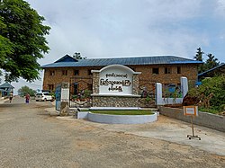 Hospital in Namhkan
 -
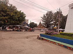
 Road in Namhkan


References
[edit]- ^Myanmar Information Management Unit (2019).Namhkan Myone Daethasaingyarachatlatmyaနမ့်ခမ်းမြို့နယ် ဒေသဆိုင်ရာအချက်လက်များ[Namkham Township Regional Information](PDF)(Report). MIMU.Retrieved8 November2023.
- ^Nisbet, John (1901).Burma Under British Rule and Before.Adamant Media Corporation, 2005. pp. 36–40.ISBN978-1-4021-5293-1.Retrieved2009-03-03.
- ^Carl Warren Weidenburner."The Ledo Road- MILEPOSTS".University of Oklahoma Press.Archived fromthe originalon 2007-12-20.Retrieved2009-03-02.
- ^abWin Nyunt Lwin."Historic road links wilderness and culture".Myanmar TimesOctober 4–10, 2004. Archived fromthe originalon 2008-10-06.Retrieved2009-03-04.
- ^"Curfew for northern township follows rout".S.H.A.N. 2005-12-29. Archived fromthe originalon 2009-02-11.Retrieved2009-03-04.
- ^"The big chase".S.H.A.N. 2006-01-03. Archived fromthe originalon 2009-02-11.Retrieved2009-03-04.
- ^Nyein, Nyein (1 August 2014)."Burma Working With China on Border Dispute in Shan State, FM Says".The Irrawaddy.Retrieved12 August2018.
- ^Now, Myanmar (2023-11-06)."နမ့်ခမ်းတစ်မြို့လုံးနီးပါး TNLA ထိန်းချုပ်".Myanmar Now.Retrieved2023-11-06.
- ^https://twitter /Myanmar_Now_Eng/status/1737453983201992880[bare URL]
- ^"TNLA Declares Complete Control over Namhkam Township, Including Military Council's Sakhanthit Hill Base".
- ^"Shan Herald Agency for News (S.H.A.N.)".Shanland.org. Archived fromthe originalon 29 November 2014.Retrieved17 November2014.
- ^"Replacing Opium in Kokang and Wa Special Regions, Shan State, Myanmar"(PDF).UNODC.2003. p. 6.Retrieved2009-03-02.
- ^"Community-run rehab centers in the north".Shan Herald Agency for News(S.H.A.N.). Archived fromthe originalon 2009-02-11.Retrieved2009-03-04.
- ^TheSanghaMetta Project (November 2000)."HIV/AIDS education and training in Yunnan, China and the Shan State, Burma".buddhanet.net.Retrieved2009-03-04.
- ^"Lt-Gen Aung Htwe inspects harvesting, cultivation tasks in Namhkham".New Light of Myanmar.June 12, 2004. Archived fromthe originalon September 3, 2005.Retrieved2009-03-02.
- ^"Burma: Seedlings of evil".grain.org(in Spanish).Retrieved2021-12-24.
- ^"Shweli Hydel Power Project".Ministry of Foreign Affairs. September 1, 2003. Archived fromthe originalon January 15, 2006.Retrieved2009-03-03.
- ^"Myanmar to implement some six hydropower projects".People's Dailyonline, April 21, 2007.Retrieved2009-03-03.
- ^ab"World War II Timeline:Chinese struggles to provide medical care".HowStuffWorks. 11 September 2007.Retrieved2009-03-02.
- ^"SEAGRAVE GS".Ncbi.nlm.nih.gov.Retrieved17 November2014.
External links
[edit]- Satellite mapGeoNames
- Taipei American Chamber of Commerce; Topics Magazine, Analysis, November 2012.Myanmar: Southeast Asia's Last Frontier for Investment,BY DAVID DUBYNE
- Oilseedcrops.org; Editor Article, Transit routes from western China through Myanmar.Myanmar: the Missing Link from Western China to India’s N.E. States
23°50′00″N97°41′00″E/ 23.83333°N 97.68333°E

