
Nathia Gali
Nathoka Gali
نتھوکا گلی | |
|---|---|
 Nathia Gali'sSt. Matthew's Church, which was built duringBritish colonial rule,photographed in 2014 | |
 Nathia Gali  Nathia Gali | |
| Coordinates:34°04′N73°23′E/ 34.067°N 73.383°E | |
| Country | |
| Province | |
| District | Abbottabad District |
| Tehsil | Abbottabad Tehsil |
| Government | |
| •Nazim | Sardar Fayyaz Khan Dahir[1] |
| •Naib Nazim | Sardar Zaheed |
| •V.C. Naib Nazim | Wali Ur Rehman Khan |
| Elevation | 2,410 m (7,910 ft) |
| Time zone | UTC+5:00(Pakistan Standard Time) |


Nathia GaliorNathiagali(Urdu:نتھیا گلی) is ahill stationandmountain resorttown located in theAbbottabad DistrictofKhyber Pakhtunkhwa,Pakistan.It is located at the centre of theGalyatrange, where several hill stations are situated. Nathia Gali is known for its scenery,hikingtrails and weather,[citation needed]which is much cooler than the rest of the Galyat range due to it being at a higheraltitude.It is situated approximately 32 kilometres (20 mi) away from bothMurreeandAbbottabad.[2][3]
History
[edit]DuringBritish rule,Nathia Gali, then part of Abbottabad tehsil of Hazara District, served as the summer headquarters of the Chief Commissioner of the (then)Peshawardivision of thePunjab.[4]The town, along withDunga Galiconstituted anotified areaunder the Punjab Municipalities Act, 1891. The income in 1903-04 was Rs. 3,000, chiefly derived from a house tax, while expenditure was Rs. 1,900.
Climate
[edit]Theweatherof Nathia Gali remains cool, pleasant andfoggyinsummers(1 May to 31 August). During themonsoonseason (1 July to 16 September),rainis expected almost every day. Cool winds start to lower temperatures inautumn.Winters(1 November to 28 February) are cold and chilly. In December and January, heavysnowfallmay occur. The weather remains cool throughout thespring.In Nathia Gali, the most comfortable weather is during the summer season.[5]Frequent rainfall occurs here annually. Annual rainfall ranges between 1,650 millimetres (65 in) and 1,850 millimetres (73 in). In the winter, temperatures can drop to below −10 °C (14 °F), and in summer it rise to highs over 30 °C (86 °F).
Transportation
[edit]The town is connected toAbbottabadandMurreeby the Nathia Gali road. Public transport runs daily fromAbbottabadandRawalpindito Nathia Gali.
Between December and January, heavy snowfall is possible in the area and the road leading to Nathia Gali may occasionally be blocked by heavy snow.
Tourism
[edit]
Nathia Gali also serves as the administrative centre of the Nathia GaliUnion Council.It is located in theAbbottabad District,inKhyber Pakhtunkhwa.At an elevation of 2,410 metres (7,910 ft), it is a populartouristresort in the summer months. It is forested withpine,cedar,oak,walnutand also otherbroad-leaved trees.
During the summer, Nathia Gali is relatively popular amongst tourists, but due to its limited area and availability of property, it is not thronged by as many people as the hill-station Murree, which is only an hour away, even though it has more recreation. Nathiagali is known for its trek that leads toThandianithat passes throughDagri Naka.[6]
Ayubia National Parkis also one of the spots here that tourists and nature lovers often visit.
The Nathia GaliBazaarhas a variety of local handicrafts and products available. From traditional shawls, scarves, and embroidered fabrics to intricate woodwork and handmade jewelry, this bazaar is a treasure trove for souvenir hunters.[7]
Scenery
[edit]
The natural scenery is highly attractive. Nathia Gali is famous for its lush, green meadows and deep forests of oak, cedar and pine. In winter, snowfall adds to the scene. Nathia Gali has achurch,St. Matthew's, a remnant from theBritish periodand made entirely of wood. It is situated at the edge of themountainwith a nice panorama towardsKashmir. Nathia Gali has a smallbazaar.MukshpuriandMiranjaniare two nearby high peaks. On a clear day,Nanga Parbatcan be seen in the distance.
Wildlife
[edit]Nathia Gali is home to various species of birds, insects, butterflies and other animals such asrhesus monkeys.TheWorld Wildlife Fundhas an office in the Galyat and has assisted in the breeding and reintroduction of the species of the near-extinct common hillleopardin the forests of the Ayubia National Park, right by Dunga Gali and Nathia Gali. This area was thought to be a perfect habitat for them but according to local reports they frequently came out of the forest after cattle of the local villagers and were occasionally shot. Packs of pi-dogs, which were previously considered to be a nighttime menace, can no longer be seen anywhere in the Galyat; it is thought that most have been killed by leopards.
In the summer of 2006, several women were found dead in the deep valleys of Galyat with wounds from attacks. A large leopard was caught and eventually shot. His body has been stuffed and kept in the Dunga Gali Wildlife Museum, where he has been named the 'Ghost of Galyat'. However, despite their reputation, these leopards are rarely spotted.
Subdivisions
[edit]
The Union Council of Nathia Gali is divided into the following areas: Bagan, Donga Gali, Jhansa, Keri Sarafali, Keri Raiki, Lassan, Malach, Nathiagali Pasala, and Badhair. Badhair is the central part of the Nathiagali Union Council.[1]
Ethnic groups
[edit]The main tribe of Nathia Gali are theKarlal,and a minority of Dhunds (who now call themselves 'Dhund-Abbasis').[8]The locals are a kin to the people of other parts ofGalyatand speakHindko.Until well into the 1960s, most of these tribes and clans were mostly living rather basic and primitive lives, due to lack of educational and employment opportunities.[9]Most of them had to seek jobs and education down in the plains and cities such asRawalpindi,Lahore,Peshawarand even as far away asKarachi.However, in more recent times, with economic development, many of them are either employed locally in the tourism industry or in various jobs and businesses in the Abbottabad area. It is monitored by GDA.[citation needed][clarification needed]
Gallery
[edit]-
-

-

-
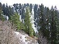
 Pipeline Track, Ayubia National Park
 -
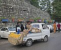 Mango street vendor at the Main Bazar


See also
[edit]References
[edit]- ^abNathia Gali Union Council
- ^Nathia Gali - Imperial Gazetteer of India, v. 18, p. 415
- ^NathiagaliArchived2012-08-28 at theWayback Machine,Publisher: Tourism Development Corporation of Punjab (TDCP). Retrieved 27 October 2012
- ^These areas later became part of the thenNorth West Frontier Provincefrom 1901 onwards
- ^Nathiagali weather forecast,Publisher: nathiagali. Retrieved 10 November 2012.
- ^"Attractions".Archived fromthe originalon 2015-01-02.Retrieved2015-01-02.
- ^"Shops & Hotels in Nathia Gali".Stay in Khaira Gali.2023-09-14.Retrieved2024-01-09.
- ^Hazara Gazetteer 1921; They are akin to the people of Murree area nearby, in Punjab, a continuation of the Galyat range
- ^Hazara Divisional Report, 1991-1992,Pub. Govt. of NWFP, 1993, pp. 45-46
External links
[edit]- Places to Visit in Abbottabad
- Miranjani Trek by Shaikh Muhammad Ali
- The Pipe Line Trek by Shaikh Muhammad Ali
- Mokshpuri Trek by Shaikh Muhammad Ali
- http:// nathiagali
 Murreetravel guide from Wikivoyage
- Nathiagali Pictures
- Governor's House
- Sarhad Tourism Corporation, Government of Khyber Pakhtunkhwa, Pakistan
- http:// nathiagali /?page_id=16
- Hotels in Nathiagali (reservation)
- Hotel in Nathiagali (book your corporate event)
- FAQ about Nathiagali (Question Answers about Nathiagali)
34°04′05″N73°23′32″E/ 34.06806°N 73.39222°E
| International | |
|---|---|
| National | |
| Geographic | |