
Neillsville, Wisconsin
Neillsville, Wisconsin | |
|---|---|
 City hall | |
 Location of Neillsville in Clark County, Wisconsin. | |
| Coordinates:44°33′40″N90°35′45″W/ 44.56111°N 90.59583°W | |
| Country | United States |
| State | Wisconsin |
| County | Clark |
| Area | |
| • Total | 2.85 sq mi (7.37 km2) |
| • Land | 2.75 sq mi (7.11 km2) |
| • Water | 0.10 sq mi (0.26 km2) |
| Elevation | 1,037 ft (316 m) |
| Population | |
| • Total | 2,384 |
| • Density | 877.60/sq mi (338.89/km2) |
| Time zone | UTC-6(Central (CST)) |
| • Summer (DST) | UTC-5(CDT) |
| ZIP Code | 54456 |
| Area code(s) | 715 & 534 |
| FIPS code | 55-55800[4] |
| GNISfeature ID | 1570146[2] |
| Website | www |
Neillsvilleis a city andcounty seatofClark County, Wisconsin,United States. The population was 2,384 at the2020 census.[6]
History
[edit]
TheOjibwawere the earliest known residents of the Neillsville area.[7]
The first settlers of European descent in the area wereJames O'Neilland his party, who arrived around 1845, looking for a location to build asawmillalong theBlack River.The city was named in honor of O'Neill, as was O'Neill Creek, which runs through the center of the city and drains into the Black River.
In 1854, O’Neill's Mill, as Neillsville was originally called, was selected as the county seat ofClark County.[8]
Neillsville wasplattedon April 14, 1855, andincorporatedin April 1882.[9]
AWinnebagoIndian boarding schoolwas operated by theEvangelical and Reformed Churchon the west side of Neillsville from 1921 to 1957.[10][11]
Neillsville is where noted architectWilliam L. Steeledied. Poor health had forced Steele to retire from architecture in late 1946, leaving his eldest son William L. Steele Jr. and partner Josiah D. Sandham in charge of the practice. Steele had come to Neillsville to live with one of his daughters, Sallie (Mrs. Thomas S. Noble Jr.), and died at her house on March 4, 1949.[12][13]
Geography
[edit]Neillsville is located at44°33′40″N90°35′45″W/ 44.56111°N 90.59583°W(44.560996, -90.595746).[14]
According to theUnited States Census Bureau,the city has a total area of 2.87 square miles (7.43 km2), of which, 2.77 square miles (7.17 km2) is land and 0.10 square miles (0.26 km2) is water.[15]
The city lies onUS Highway 10andState Trunk Highway 73.

Climate
[edit]| Climate data for Neillsville 3ESE, Wisconsin (1991–2020 normals, extremes 1893–present) | |||||||||||||
|---|---|---|---|---|---|---|---|---|---|---|---|---|---|
| Month | Jan | Feb | Mar | Apr | May | Jun | Jul | Aug | Sep | Oct | Nov | Dec | Year |
| Record high °F (°C) | 57 (14) |
62 (17) |
83 (28) |
91 (33) |
105 (41) |
104 (40) |
106 (41) |
103 (39) |
98 (37) |
92 (33) |
81 (27) |
64 (18) |
106 (41) |
| Mean daily maximum °F (°C) | 23.5 (−4.7) |
28.7 (−1.8) |
41.0 (5.0) |
55.4 (13.0) |
67.8 (19.9) |
76.6 (24.8) |
80.4 (26.9) |
78.2 (25.7) |
70.8 (21.6) |
57.7 (14.3) |
41.9 (5.5) |
28.9 (−1.7) |
54.2 (12.3) |
| Daily mean °F (°C) | 14.4 (−9.8) |
18.4 (−7.6) |
30.4 (−0.9) |
43.6 (6.4) |
55.7 (13.2) |
65.2 (18.4) |
69.0 (20.6) |
66.9 (19.4) |
59.1 (15.1) |
46.8 (8.2) |
33.1 (0.6) |
20.8 (−6.2) |
43.6 (6.4) |
| Mean daily minimum °F (°C) | 5.4 (−14.8) |
8.2 (−13.2) |
19.8 (−6.8) |
31.9 (−0.1) |
43.7 (6.5) |
53.9 (12.2) |
57.6 (14.2) |
55.6 (13.1) |
47.3 (8.5) |
36.0 (2.2) |
24.4 (−4.2) |
12.7 (−10.7) |
33.0 (0.6) |
| Record low °F (°C) | −48 (−44) |
−46 (−43) |
−39 (−39) |
2 (−17) |
15 (−9) |
22 (−6) |
34 (1) |
31 (−1) |
14 (−10) |
4 (−16) |
−16 (−27) |
−36 (−38) |
−48 (−44) |
| Averageprecipitationinches (mm) | 1.11 (28) |
1.08 (27) |
1.74 (44) |
3.26 (83) |
4.45 (113) |
5.34 (136) |
3.85 (98) |
4.36 (111) |
4.01 (102) |
3.08 (78) |
1.80 (46) |
1.44 (37) |
35.52 (902) |
| Average snowfall inches (cm) | 9.1 (23) |
9.4 (24) |
7.7 (20) |
2.7 (6.9) |
0.0 (0.0) |
0.0 (0.0) |
0.0 (0.0) |
0.0 (0.0) |
0.0 (0.0) |
0.4 (1.0) |
3.4 (8.6) |
10.9 (28) |
43.6 (111) |
| Average precipitation days(≥ 0.01 in) | 7.4 | 6.3 | 7.8 | 10.6 | 12.3 | 12.5 | 10.0 | 10.4 | 10.1 | 9.3 | 6.9 | 7.9 | 111.5 |
| Average snowy days(≥ 0.1 in) | 5.8 | 5.0 | 3.3 | 1.5 | 0.0 | 0.0 | 0.0 | 0.0 | 0.0 | 0.3 | 2.0 | 5.6 | 23.5 |
| Source:NOAA[16][17] | |||||||||||||
Demographics
[edit]| Census | Pop. | Note | %± |
|---|---|---|---|
| 1880 | 1,050 | — | |
| 1890 | 1,936 | 84.4% | |
| 1900 | 2,104 | 8.7% | |
| 1910 | 1,957 | −7.0% | |
| 1920 | 2,160 | 10.4% | |
| 1930 | 2,118 | −1.9% | |
| 1940 | 2,562 | 21.0% | |
| 1950 | 2,663 | 3.9% | |
| 1960 | 2,728 | 2.4% | |
| 1970 | 2,750 | 0.8% | |
| 1980 | 2,780 | 1.1% | |
| 1990 | 2,680 | −3.6% | |
| 2000 | 2,731 | 1.9% | |
| 2010 | 2,463 | −9.8% | |
| 2020 | 2,384 | −3.2% | |
| U.S. Decennial Census[18] | |||
2010 census
[edit]As of thecensus[3]of 2010, there were 2,463 people, 1,095 households, and 586 families living in the city. Thepopulation densitywas 889.2 inhabitants per square mile (343.3/km2). There were 1,230 housing units at an average density of 444.0 per square mile (171.4/km2). The racial makeup of the city was 96.2%White,0.4%African American,0.7%Native American,1.1%Asian,0.9% fromother races,and 0.7% from two or more races.HispanicorLatinoof any race were 2.3% of the population.
There were 1,095 households, of which 24.7% had children under the age of 18 living with them, 39.1% weremarried couplesliving together, 10.5% had a female householder with no husband present, 3.9% had a male householder with no wife present, and 46.5% were non-families. 42.3% of all households were made up of individuals, and 22.8% had someone living alone who was 65 years of age or older. The average household size was 2.13 and the average family size was 2.92.
The median age in the city was 43.6 years. 21.8% of residents were under the age of 18; 8.5% were between the ages of 18 and 24; 21.3% were from 25 to 44; 24.7% were from 45 to 64; and 23.7% were 65 years of age or older. The gender makeup of the city was 46.6% male and 53.4% female.
2000 census
[edit]As of thecensus[4]of 2000, there were 2,731 people, 1,130 households, and 653 families living in the city. Thepopulation densitywas 975.3 people per square mile (376.6/km2). There were 1,200 housing units at an average density of 428.5 per square mile (165.5/km2). The racial makeup of the city was 96.78%White,0.15%African American,1.10%Native American,1.24%Asian,0.04%Pacific Islander,0.26% fromother races,and 0.44% from two or more races.HispanicorLatinoof any race were 0.95% of the population.
There were 1,130 households, out of which 27.1% had children under the age of 18 living with them, 44.5% weremarried couplesliving together, 10.1% had a female householder with no husband present, and 42.2% were non-families. 38.1% of all households were made up of individuals, and 21.3% had someone living alone who was 65 years of age or older. The average household size was 2.24 and the average family size was 2.99.
In the city, the population was spread out, with 25.3% under the age of 18, 7.0% from 18 to 24, 24.2% from 25 to 44, 18.7% from 45 to 64, and 24.8% who were 65 years of age or older. The median age was 40 years. For every 100 females, there were 86.2 males. For every 100 females age 18 and over, there were 79.3 males.
The median income for a household in the city was $29,969, and the median income for a family was $41,076. Males had a median income of $30,523 versus $20,379 for females. Theper capita incomefor the city was $16,298. About 6.3% of families and 10.3% of the population were below thepoverty line,including 6.8% of those under age 18 and 8.9% of those age 65 or over.
Transportation
[edit]
Neillsville is served by theNeillsville Municipal Airport(KVIQ).
Education
[edit]
Neillsville has a public K-12 school system, consisting of Neillsville Elementary School, Neillsville Middle School, and Neillsville High School, whose mascot is the Neillsville Warriors. Neillsville is also home to St. John's Lutheran School, a private school for grades K-8 of theWisconsin Evangelical Lutheran Synod,[19]and the former home of St. Mary's School of Neillsville,[20]a Catholic school which closed in 1972.[21]
In addition, theChippewa Valley Technical Collegehas a regional center in Neillsville, which offersGED,associate's degree,andcontinuing educationclasses.
Points of interest
[edit]The High Groundis a veterans' memorial park located west of Neillsville. Originally a memorial to Vietnam War veterans, it now includes memorials to World War I, World War II, and Korean War veterans.
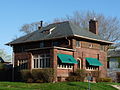
TheClark County Jail,now a museum, and theReed School,now a museum, are on theNational Register of Historic Places.
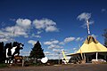
TheWisconsin Pavilionfrom the1964 New York World's Fairwas moved to Neillsville at the conclusion of the Fair. The building is now home to local radio stationWCCN/WCCN-FMand a gift shop. Chatty-Belle is a large cow statue located on the ground of the Wisconsin Pavilion. She has the distinction of being the World's Largest Talking Cow.[22]
-
 Wisconsin's 1964 World's Fair exhibit
 -
 Chatty Belle, the world's largest talking cow, part of Wisconsin's contribution to the 1964 World's Fair.
 -
 The oldClark County Jail,built in 1897, is now a historical museum.
 -
 Gazebo in downtown
 -

-

-

-

-
-
-


See also
[edit]References
[edit]- ^"2019 U.S. Gazetteer Files".United States Census Bureau.RetrievedAugust 7,2020.
- ^ab"US Board on Geographic Names".United States Geological Survey.October 25, 2007.RetrievedJanuary 31,2008.
- ^ab"U.S. Census website".United States Census Bureau.RetrievedNovember 18,2012.
- ^ab"U.S. Census website".United States Census Bureau.RetrievedJanuary 31,2008.
- ^"Population and Housing Unit Estimates".United States Census Bureau. May 24, 2020.RetrievedMay 27,2020.
- ^"Find a County".National Association of Counties.RetrievedJune 7,2011.
- ^Author unknown. "The Heart of WisconsinArchived2007-07-27 at theWayback Machine",1900 (estimated).
- ^MacBridge, R. J. "The History of Clark County".Thorp Courier,June 17, 1909.
- ^Clark County, WI Internet Library Project. "Pine Valley Township, Clark County, WisconsinArchived2008-01-05 at theWayback Machine".Retrieved on 2007-10-25.
- ^"Winnebago Indian Mission School".Wisconsin Historical Society.RetrievedSeptember 1,2023.
- ^"Interactive Digital Map of Indian Boarding Schools".The National Native American Boarding School Healing Coalition.RetrievedSeptember 1,2023.
- ^"Obit: Steele, William LaBarthe (1875 - 1949)".Clark County Press.Neillsville, Wisconsin. March 10, 1949.
- ^Withey, Henry F; Withey, Elsie Rathburn (1956).Biographical Dictionary of American Architects (Deceased).Los Angeles: New Age Publishing Co. p.569.
- ^"US Gazetteer files: 2010, 2000, and 1990".United States Census Bureau.February 12, 2011.RetrievedApril 23,2011.
- ^"US Gazetteer files 2010".United States Census Bureau.Archived fromthe originalon January 25, 2012.RetrievedNovember 18,2012.
- ^"NOWData - NOAA Online Weather Data".National Oceanic and Atmospheric Administration.RetrievedMarch 31,2024.
- ^"Summary of Monthly Normals 1991-2020".National Oceanic and Atmospheric Administration.RetrievedMarch 31,2024.
- ^"Census of Population and Housing".Census.gov.RetrievedJune 4,2015.
- ^"St. John's Neillsville".
- ^"Many Attend Music Festival Held at Loyal".The Marshfield News-Herald.Vol. 41, no. 14.Marshfield, Wisconsin.March 22, 1961. p. 10.RetrievedJanuary 2,2024– viaNewspapers.
- ^"School: Neillsville St. Mary's (Closing 1972)".usgennet.org.RetrievedJanuary 2,2024.
- ^"Neillsville Area Chamber of Commerce -- Neillsville, Wisconsin".neillsville.org.Archived fromthe originalon July 27, 2011.
External links
[edit]- City of Neillsville official website
- Neillsville Area Chamber of Commerce
- School District of Neillsville
- Historical & Architectural Tour Of Neillsville
- Sanborn fire insurance maps:1887189219031914
Municipalities and communities ofClark County, Wisconsin,United States | ||
|---|---|---|
| Cities |  | |
| Villages | ||
| Towns | ||
| CDPs | ||
| Unincorporated communities | ||
| Ghost towns | ||
| Indian reservation | ||
| Footnotes | ‡This populated place also has portions in an adjacent county or counties | |
| International | |
|---|---|
| National | |